Wadi Derna
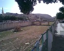
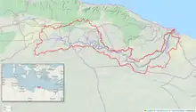
Wadi Derna is a river valley in Libya which leads down from the Jebel Akhdar mountains to the port city of Derna. Like many other wadis in North Africa, it is an intermittent riverbed that for much of its length contains water only when heavy rain occurs.[1] It is 75 kilometres (47 mi) long[2] and drains a drainage basin of 575 km2.
| Wadi Derna | |
|---|---|
 Wadi Derna, January 2010 | |
 Map showing watershed | |
| Physical characteristics | |
| Mouth | Mediterranean Sea |
• coordinates | 32°46′02″N 22°39′05″E |
| Basin features | |
| Cities | Derna |
| Waterfalls | Derna waterfalls |
Derna waterfalls
The Derna waterfalls are located in Wadi Derna[1] about 7 km (4.3 mi) to the south of Derna.[3]
2023 Derna catastrophe
In September 2023, against the backdrop of the civil war, the rainfall from the Storm Daniel led to the collapse of two dams across the river, the Derna dam and the Abu Mansour dam, causing catastrophic flooding in the city of Derna, which killed at least 4,000 people.[4][5][6] It was one of the deadliest dam failures in history.
References
- Mellen, Ruby; Karklis, Laris; Granados, Samuel; Ledur, Júlia; Stillman, Dan (12 September 2023). "Mapping why Libya's floods were so deadly". Washington Post. Retrieved 13 September 2023.
- C.B.M. McBurney; R.W. Hey (1955). "VII, Tufaceous deposits". Prehistory and Pleistocene Geology in Cyrenaican Libya. Cambridge University Press. ISBN 9780521056243. Retrieved 2023-09-14 – via books.google.co.uk.
- Alex Olorenshaw; Faisal Ali; Harvey Symons; Glenn Swann (2023-09-12). "Destruction in Derna: how floods ravaged Libyan port city". www.theguardian.com. Retrieved 2023-09-14.
- "Death toll hits 11,300 in Libyan city destroyed by floods". NBC News. 2023-09-14. Retrieved 2023-09-15.
- "Bodies wash ashore in Libya as devastated city races to count its dead". NBC News. 2023-09-13. Retrieved 2023-09-14.
- Akbarzai, Salih; Roth, Richard (17 September 2023). "UN revises previous high Libya death toll". CNN. Archived from the original on 18 September 2023. Retrieved 18 September 2023.