Vipava (river)
The Vipava (Italian: Vipacco; German: Wipbach or Wippach) is a river that flows through western Slovenia and north-eastern Italy. The river is 49 kilometres (30 mi) in length, of which 45 km in Slovenia.[1] After entering Italy it joins the Isonzo/Soča in the Municipality of Savogna d'Isonzo. This is a rare river with a delta source, formed by nine main springs.[3] The Battle of the Frigidus was fought near the river, which was named Frigidus ('cold') by the Romans. It has a pluvial-nival regime in its upper course and a pluvial regime in its lower course.[4]
| Vipava | |
|---|---|
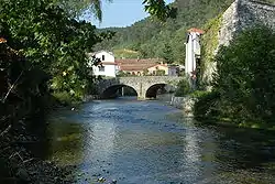
 The Vipava in Vipava, flowing under the Tabor Bridge | |
| Location | |
| Country | Italy, Slovenia |
| Physical characteristics | |
| Source | |
| • location | Vipava (in Slovenia) |
| • elevation | 110 m (360 ft) [1] |
| Mouth | |
• location | The Soča (in Italy) |
• coordinates | 45.8990°N 13.5533°E |
• elevation | 35 m (115 ft) [1] |
| Length | 49 km (30 mi) [1] |
| Basin size | 760 km2 (290 sq mi) |
| Discharge | |
| • average | 17.31 m3 (611 cu ft)[2] |
| Basin features | |
| Progression | Soča→ Adriatic Sea |
See also
References
- Rivers, longer than 25 km, and their catchment areas, Statistical Office of the Republic of Slovenia
- "Vipava" [Camis Project: Coherent Activities for the Management of the River Soča]. Projekt Camis - Usklajene aktivnosti za upravljanje reke Soče (in Slovenian and Italian). Soča Development Centre. Retrieved 8 February 2006.
- Omejc, Alenka (2009). Humar, Janko (ed.). "The Emerald Trail". RDO Smaragdna pot. COBISS 579912.
{{cite journal}}: Cite journal requires|journal=(help) - Brečko Grubar, Valentina; Kovačič, Gregor (2010). "Pokrajinskoekološka oznaka jadranskega povodja v Sloveniji s poudarkom na kakovosti vodnih virov" [Landscape Ecological Characterization of the Adriatic Sea Basin in Slovenia with an Emphasis on Water Resource Quality]. Annales. Series historia et sociologia (in Slovenian). 20 (1): 153–168.
External links
 Media related to Vipava (river) at Wikimedia Commons
- Condition of Vipava at Dolenje, Dornberk, Miren - graphs, in the following order, of water level, flow and temperature data for the past 30 days (taken in Dolenje, Dornberk and Miren by ARSO)
This article is issued from Wikipedia. The text is licensed under Creative Commons - Attribution - Sharealike. Additional terms may apply for the media files.
