Vilyuy Plateau
The Vilyuy Plateau (Russian: Вилюйское плато, romanized: Vilyuyskoye Plato) is a mountain plateau in Krasnoyarsk Krai and the Sakha Republic (Yakutia), Siberia, Russia. It is a part of the Central Siberian Plateau and it is made up mainly of the upper course section of the Vilyuy River.
| Vilyuy Plateau | |
|---|---|
| Вилюйское плато | |
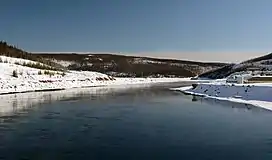
 View of the Vilyuy Reservoir | |
| Highest point | |
| Peak | Unnamed |
| Elevation | 962 m (3,156 ft) |
| Dimensions | |
| Length | 400 km (250 mi) |
| Width | 200 km (120 mi) |
| Geography | |
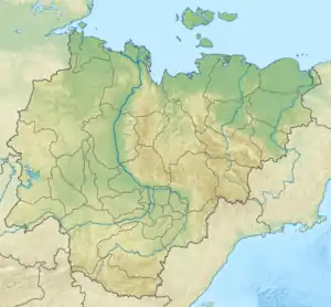
 Location in Yakutia, Russia | |
| Country | Russia |
| Federal subject | Krasnoyarsk Krai and Sakha Republic |
| Range coordinates | 66°30′N 109°45′E |
| Parent range | Central Siberian Plateau |
| Borders on | Irkutsk Oblast |
| Geology | |
| Age of rock | Lower Paleozoic and Precambrian |
| Type of rock | Trap rock, dolomite and Limestone |
Permafrost thickness up to 1,500 metres (4,900 ft), the largest in the world, was discovered under the Vilyuy Plateau.[1][2]
Geography
The Vilyuy Plateau is located both north and south of the Arctic Circle in northeastern Krasnoyarsk Krai and western Sakha Republic. To the southwest it borders Irkutsk Oblast.[3] To the north rises the Anabar Plateau, to the west the Syverma Plateau and to the northwest the Putorana Mountains. To the east the plateau descends gradually towards the broad Lena River valley and to the southeast it runs into the Central Yakutian Lowland, which leads to the Lena Plateau on the southern side. The average height of the Vilyuy Plateau surface is around 700 meters (2,300 ft) and the highest point is a 962 metres (3,156 ft) high unnamed summit.[4]
The major rivers having their source in the plateau are the Vilyuy, Markha, Olenyok, Ygyatta and Lakharchana, as well as the Akhtaranda —with the Alymdya and Olguydakh. Rivers Ulakhan-Botuobuya, Sen and Chirkuo flow across it.[3] There are also numerous lakes, including Suringda and the man-made Vilyuy Reservoir.[5]
Flora and climate
There is larch taiga on the mountain slopes, with thickets of prostrate alder and mountain tundra on the higher elevations. There are meadows in the river valleys.[4]
The climate prevailing in the Vilyuy Plateau is subarctic continental. The winters are some of the most severe in the Northern Hemisphere.[4]
References
- Vilyui plateau // Dictionary of modern geographical names / Rus. geo about . Mosk. center; Under the total. ed. Acad. V.M. Kotlyakova . Institute of Geography RAS . - Yekaterinburg: U-Factoria, 2006
- A review of the nature and geophysical studies of the thick permafrost in Siberia
- Google Earth
- Вилюйское плато Great Soviet Encyclopedia in 30 vols. / Ch. ed. A.M. Prokhorov . - 3rd ed. - M, 1969-1978.
- "P-49-50 Topographic Chart (in Russian)". Retrieved 24 March 2023.
External links
 Media related to Vilyuy Plateau at Wikimedia Commons
- Soil Cover of the North of Central Siberia
- Analyzing winter migration fidelity and movement of the wild Taimyr reindeer herd, Rangifer T. tarandus