Ukinrek Maars
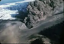
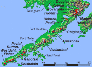
The Ukinrek Maars are two volcanic craters on the north side of the Aleutian Range in Alaska that were formed by a phreatomagmatic eruption in 1977. The maars are 1.5 km south of Becharof Lake and 12 km northwest of Peulik Volcano, on a low area of the range, bordering the Bering Sea. The western of the two is elliptical in shape and up to 170 m in diameter and 35 m deep. The other lies 600 m to the east and is circular and up to 300 m in diameter and 70 m deep. The east maar has a 49 m-high lava dome within its crater lake.[2]
| Ukinrek Maars | |
|---|---|
| Highest point | |
| Elevation | 299 ft (91 m) |
| Coordinates | 57°49′54″N 156°30′35″W[1] |
| Geography | |
| Location | Becharof National Wildlife Refuge, Alaska, on Alaska Peninsula |
| Parent range | Aleutian Range |
| Geology | |
| Mountain type | Maars |
| Last eruption | March–April 1977 |
The eruption occurred in March–April 1977 and lasted for ten days. There was no previous eruption. The magmatic material was olivine basalt from a mantle source. Pyroclastic surge from the eruptions traveled to the northwest.[1] The volume of lava erupted was 9×10⁵ m3 and the volume of tephra expelled was 2.6×10⁷ m3.[3]
The Quaternary age Gas Rocks dacite domes some three km to the northeast were the site of a phreatic eruption some 2300 years ago.[1]


References
- "Ukinrek Maars". Global Volcanism Program. Smithsonian Institution. Retrieved 2021-06-28.
- Miller, T.P., et al., 1998, Catalog of the historically active volcanoes of Alaska: U.S. Geological Survey Open-File Report 98-0582, 104 p
- "Ukinrek Maars: Eruptive History". Global Volcanism Program. Smithsonian Institution. Retrieved 2021-06-28.
External links
- Volcanoes of the Alaska Peninsula and Aleutian Islands-Selected Photographs
- Alaska Volcano Observatory