U.S. Route 60 in West Virginia
U.S. Route 60 (US 60) runs northwest to southeast across the central and southern portions of West Virginia. It runs from the Kentucky state line at Catlettsburg, Kentucky and Kenova. The road passes through Huntington, Charleston, and White Sulphur Springs. The route exits the state into Virginia concurrently with Interstate 64 east of White Sulphur Springs. Most of US 60's route through West Virginia is part of and even signed in several areas as the Midland Trail.
_at_Harts_Run_Road_(Greenbrier_County_Route_60-14)_in_White_Sulphur_Springs%252C_Greenbrier_County%252C_West_Virginia.jpg.webp)
View west along US 60 at CR 60/14 departing White Sulphur Springs
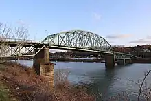
US 60 crossing the Kanawha River at the Patrick Street Bridge in Charleston
U.S. Route 60 | ||||
|---|---|---|---|---|
| Midland Trail | ||||
US 60 highlighted in red | ||||
| Route information | ||||
| Maintained by WVDOH | ||||
| Length | 177.8 mi[1] (286.1 km) | |||
| Existed | 1926–present | |||
| Major junctions | ||||
| West end | ||||
| ||||
| East end | ||||
| Location | ||||
| Country | United States | |||
| State | West Virginia | |||
| Counties | Wayne, Cabell, Putnam, Kanawha, Fayette, Greenbrier | |||
| Highway system | ||||
| ||||

Major intersections
| County | Location | mi[1] | km | Destinations | Notes |
|---|---|---|---|---|---|
| Big Sandy River | 0.000– 0.085 | 0.000– 0.137 | Continuation into Kentucky | ||
| Billy C. Clark Bridge | |||||
| Wayne | Kenova | 1.2 | 1.9 | Western terminus of WV 75; serves Tri-State Airport | |
| Cabell | Huntington | 6.5– 6.6 | 10.5– 10.6 | Interchange | |
| 8.5 | 13.7 | One-way street, inbound access only, at-grade intersection eastbound; entrance-only interchange westbound; west end of overlap with WV 527 | |||
| 8.6 | 13.8 | East end of overlap with WV 527; eastbound access only | |||
| 8.8 | 14.2 | Signed westbound only | |||
| 9.5 | 15.3 | Northern terminus of WV 10 at US 60 west | |||
| Westbound access only; southern terminus of WV 2 | |||||
| 11.6 | 18.7 | 5th Avenue east | |||
| Barboursville | 14.7– 15.1 | 23.7– 24.3 | I-64 exit 15 | ||
| 16.5 | 26.6 | Northern terminus of WV 10 Alt | |||
| 18.2 | 29.3 | Southern terminus of WV 193 | |||
| 20.2 | 32.5 | ||||
| | 20.8 | 33.5 | |||
| | 21.4 | 34.4 | |||
| Ona | 23.0 | 37.0 | |||
| Milton | 27.2 | 43.8 | |||
| 27.5 | 44.3 | ||||
| 28.0 | 45.1 | ||||
| Culloden | 29.3 | 47.2 | |||
| 31.0 | 49.9 | ||||
| Putnam | Hurricane | 32.9 | 52.9 | Southern terminus of WV 34 Bus | |
| 34.2 | 55.0 | West end of WV 34 overlap | |||
| 34.4– 34.6 | 55.4– 55.7 | East end of WV 34 overlap | |||
| | 38.8 | 62.4 | |||
| | 39.6 | 63.7 | |||
| | 41.3 | 66.5 | |||
| Kanawha | | 41.3 | 66.5 | ||
| Amandaville | 43.7 | 70.3 | Southern terminus of WV 817 | ||
| Coal River | 44.6– 44.7 | 71.8– 71.9 | Earl Henry Curnutte Bridge | ||
| St. Albans | 45.0 | 72.4 | Second Street (CR CR 6/16) | ||
| 45.1 | 72.6 | ||||
| 46.7 | 75.2 | Walnut Street (CR CR 160/7) | |||
| | 48.2 | 77.6 | |||
| South Charleston | 50.9 | 81.9 | Rock Lake Drive | ||
| 51.1– 51.2 | 82.2– 82.4 | Dunbar Toll Bridge / Maple Street | |||
| 52.1– 52.2 | 83.8– 84.0 | I-64 exit 54 | |||
| 52.3 | 84.2 | Northern terminus of WV 601 | |||
| 52.5 | 84.5 | I-64 exit 54 | |||
| 54.2 | 87.2 | ||||
| South Charleston–Charleston line | 55.0– 55.1 | 88.5– 88.7 | Northern terminus of WV 61 | ||
| Charleston | 55.1– 55.4 | 88.7– 89.2 | Patrick Street Bridge over Kanawha River | ||
| 55.5 | 89.3 | Kanawha Boulevard West | |||
| 55.6 | 89.5 | Fourth Avenue | |||
| 55.7 | 89.6 | Begin one-way segment | |||
| 55.8 | 89.8 | Eastern terminus of WV 25 | |||
| 55.9 | 90.0 | ||||
| 55.9 | 90.0 | End one-way segment | |||
| 57.0 | 91.7 | Begin one-way segment | |||
| 57.5 | 92.5 | ||||
| 58.3 | 93.8 | Dickinson Street | |||
| 58.6 | 94.3 | ||||
| 58.6 | 94.3 | End one-way segment | |||
| 59.6 | 95.9 | Southern terminus of WV 114 | |||
| 59.7 | 96.1 | Quarrier Street | |||
| 59.8 | 96.2 | Kanawha Boulevard East | |||
| | 61.8– 62.7 | 99.5– 100.9 | West end of I-64/I-77 overlap; no access from I-64 east/I-77 south to US 60 west or from US 60 east to I-64 west/I-77 north; I-64/I-77 exit 97 | ||
| | 62.9– 63.5 | 101.2– 102.2 | East end of I-64/I-77 overlap; I-64/I-77 exit 96 | ||
| | 63.8 | 102.7 | |||
| Malden | 64.3– 64.5 | 103.5– 103.8 | Interchange | ||
| | 72.8– 73.4 | 117.2– 118.1 | |||
| Cedar Grove | 76.8 | 123.6 | |||
| Smithers | 85.0– 85.3 | 136.8– 137.3 | Interchange | ||
| Fayette | Smithers | 85.7 | 137.9 | ||
| Gauley Bridge | 95.8 | 154.2 | Main Street (CR 16/5) | ||
| 95.9– 96.0 | 154.3– 154.5 | West end of WV 16 overlap; western terminus of WV 39 | |||
| Gauley Bridge | 96.0– 96.1 | 154.5– 154.7 | Sgt. Scott Angel Memorial Bridge over Gauley River | ||
| Chimney Corner | 100.7 | 162.1 | East end of WV 16 overlap | ||
| Hico | 111.5– 111.8 | 179.4– 179.9 | |||
| | 118.7 | 191.0 | West end of WV 41 overlap | ||
| | 121.2 | 195.1 | East end of WV 41 overlap | ||
| Greenbrier | Rainelle | 131.9 | 212.3 | West end of WV 20 overlap | |
| 132.6 | 213.4 | ||||
| Charmco | 136.4 | 219.5 | East end of WV 20 overlap | ||
| | 146.2 | 235.3 | |||
| | 146.4– 146.5 | 235.6– 235.8 | I-64 exit 156 | ||
| | 152.7 | 245.7 | Northern terminus of WV 12 | ||
| | 152.8 | 245.9 | |||
| Lewisburg | 163.3 | 262.8 | |||
| 163.8 | 263.6 | ||||
| Caldwell | 166.6 | 268.1 | Eastern terminus of WV 63; Rich Creek VA only signed westbound | ||
| White Sulphur Springs | 173.7 | 279.5 | Southern terminus of WV 92 | ||
| | 174.1– 175.0 | 280.2– 281.6 | West end of I-64 overlap; access only from US 60 east to I-64 east and from I-64 west to US 60 west; I-64 exit 181 | ||
| | 176.9 | 284.7 | Interchange; Eastbound exit and westbound entrance; northern terminus of WV 311; I-64 exit 183 | ||
| | 177.8 | 286.1 | Continuation into Virginia | ||
1.000 mi = 1.609 km; 1.000 km = 0.621 mi
| |||||
References
Template:Attached KML/U.S. Route 60 in West Virginia
KML is not from Wikidata
- Google (June 28, 2020). "Google Maps Directions" (Map). Google Maps. Google. Retrieved June 28, 2020.
This article is issued from Wikipedia. The text is licensed under Creative Commons - Attribution - Sharealike. Additional terms may apply for the media files.