Typhoon Kathy
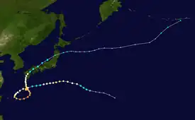
Typhoon Kathy, known in the Philippines as Typhoon Welpring, was the largest and longest-lived typhoon in 1964. As the fourteenth named storm of the season, it originated from an area of circulation southeast of Japan by August 11. The following day, the system strengthened into a tropical storm, gaining the name Kathy. Kathy reached typhoon strength on August 13, passing south of Tokyo, approaching the Ryukyu Islands. The typhoon's winds peaked at 165 km/h (103 mph) on August 14, before tapering as the storm curved west-southwest. For the next four days, Kathy and nearby Typhoon Marie began a Fujiwhara interaction, causing both storms to rotate around each other, which ended when Marie was pulled into Kathy's circulation. Between August 15 and August 16, Kathy weakened into a tropical storm, before strengthening back to typhoon status. The storm's west-southwest path brought the center across the Ryukyu Islands and near Okinawa on August 16 as Kathy began to execute a loop in its track. Two days later, Kathy's winds were estimated by the JTWC to be around 215 km/h (134 mph). The typhoon's track made a smaller loop on August 20, before heading northwards. On August 23, Kathy made landfall in Japan with winds of 130 km/h (81 mph) and weakened to a tropical storm. It then curved northeast. On August 25, Kathy transitioned into an extratropical cyclone and continued northeast, reaching the Bering Strait on September 1. Due to its lifetime and large size, the Joint Typhoon Warning Center issued warnings for 13+1⁄2 days, and the storm's circulation reached a radius of 1,370 kilometres (850 mi).[1]: 59
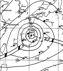
 Typhoon Kathy's surface analysis on August 20, 1964. | |
| Meteorological history | |
|---|---|
| Formed | August 10, 1964 |
| Dissipated | August 25, 1964 |
| Violent typhoon | |
| 10-minute sustained (JMA) | |
| Highest winds | 215 km/h (130 mph) |
| Lowest pressure | 948 hPa (mbar); 27.99 inHg |
| Category 4-equivalent super typhoon | |
| 1-minute sustained (SSHWS/JTWC) | |
| Highest winds | 240 km/h (150 mph) |
| Lowest pressure | 954 hPa (mbar); 28.17 inHg |
| Overall effects | |
| Fatalities | 75 |
| Damage | Unknown |
| Areas affected | Japan, Ryuku Islands |
Part of the 1964 Pacific typhoon season | |
Meteorological history

Tropical storm (39–73 mph, 63–118 km/h)
Category 1 (74–95 mph, 119–153 km/h)
Category 2 (96–110 mph, 154–177 km/h)
Category 3 (111–129 mph, 178–208 km/h)
Category 4 (130–156 mph, 209–251 km/h)
Category 5 (≥157 mph, ≥252 km/h)
Unknown
The interaction of a polar trough and easterly wave led to the genesis of an area of circulation southeast of Japan by August 11.[1]: 141 This system developed into a tropical storm, gaining the name Kathy the following day east of Iwo Jima based on ship observations.[2][3]: 76 Maintaining a west-northwestward heading, Kathy reached typhoon strength on August 13,[2] passing well south of Tokyo on approach towards the Ryukyu Islands.[4][5] The typhoon's winds peaked at 165 km/h (103 mph) on August 14 before tapering as the storm curved towards the west-southwest.[2][3]: 76 For the next four days, Kathy and nearby Typhoon Marie began a Fujiwhara interaction, causing both storms to rotate around one another, ending when Marie was absorbed into Kathy's circulation.[1]: 50 Between August 15–16, Kathy briefly fell to tropical storm intensity before regaining typhoon status southeast of Amami Ōshima.[2] During this period, an airplane investigating the storm identified multiple wind circulations at the center of Kathy and the storm's clouds were asymmetric.[6][1]: 146 The storm's west-southwest path brought the center across the Ryukyu Islands and near Okinawa on August 16 as Kathy began to execute a counterclockwise loop in its track. Two days later, Kathy's winds were estimated by the JTWC to be around 215 km/h (134 mph) near Minamidaitōjima. The typhoon's track made a smaller counterclockwise loop on August 20 before resuming north across the northern Ryukyu Islands. On August 23, Kathy made landfall on Kagoshima Prefecture with winds of 130 km/h (81 mph) and weakened to a tropical storm as it crossed the Seto Inland Sea and southern Honshu. It then curved to the northeast, briefly entering the Sea of Japan and crossing the Noto Peninsula before traversing northern Honshu and emerging into the northern Pacific.[2][3]: 76 On August 25, Kathy transitioned into an extratropical cyclone and continued northeast towards the Aleutian Islands before it was last in the Bering Strait on September 1.[2][3]: 76
Preparations and impact
According to the publication Climatological Data, Kathy caused at least 13 deaths and "numerous" injuries, with landslides and flooding being the principal cause of the casualties; as much as 700 mm (28 in) of rain was documented in the mountainous regions of Kyushu, though cities averaged 100 m (3,900 in) in rainfall accumulations.[7][3]: 76 United Press International reported as many as 24 fatalities and 8 missing persons associated with the typhoon,[8][9] with the Associated Press documenting 28 injuries.[10] Over 4,000 people were rendered homeless.[10] Kathy's effects flooded almost 1,700 homes and destroyed 8 others in Amami Ōshima; winds there reached 138 km/h (86 mph).[11][12] Sustained winds topped out at 126 km/h (78 mph) with a peak gust of 195 km/h (121 mph) on Yakushima.[13] As Kathy moved across southern and central Kyushu, damage was reported in Kagoshima, Kumamoto, Miyazaki, and Oita prefectures. Kathy's winds razed 44 houses and damaged 80 houses, with another 5,500 flooded by swollen rivers. Flooding broke through river embankments in 37 locations and washed away 18 bridges. Telecommunications and transportation services were disrupted with roads damaged in 400 locations.[14][9][15] There were at least 238 landslides caused by the typhoon, including one that derailed a passenger train in Oita Prefecture.[14][16] One landslide in Kagoshima killed 11 people.[17] Two thousand homes were flooded farther north in Fukushima Prefecture.[18] The extratropical remnants of Kathy brought gale-force winds over the Bering Sea.[3]: 76
See also
- Typhoon Kent (1992) – an intense typhoon that took a comparable track.
- Typhoon Rusa (2002) – the most powerful typhoon to strike South Korea in 43 years and took a nearly identical track.
- Typhoon Halola (2015) – a category 2 equivalent typhoon that affected similar areas.
- Typhoon Noru (2017) – a powerful typhoon that was the second-longest-lasting tropical cyclone of the Northwest Pacific Ocean on record and took a similar track.
- Typhoon Hinnamnor (2022) – a very large and strong tropical cyclone that took nearly identical track.
References
- Cassidy, Richard M., ed. (February 15, 1964). Annual Typhoon Report, 1964 (PDF) (Report). Annual Typhoon Report. Guam, Mariana Islands: Fleet Weather Central/Joint Typhoon Warning Center. Retrieved June 12, 2020.
- "1964 Super Typhoon KATHY (1964224N25161)". IBTrACS - International Best Track Archive for Climate Stewardship. Asheville, North Carolina: University of North Carolina–Asheville. 2018. Retrieved June 25, 2020.
- "Climatological Data: National Summary (Annual 1964)" (PDF). Climatological Data. Asheville, North Carolina: United States Weather Bureau. 15 (13). 1965. Archived from the original (PDF) on June 13, 2020. Retrieved June 12, 2020 – via National Centers for Environmental Information.
- "Typhoon By-Passes Tokyo". The Indianapolis News. Indianapolis, Indiana. United Press International. August 15, 1964. p. 1. Retrieved June 25, 2020 – via Newspapers.com.
- "Japan Area Has Strong Winds". Hawaii Tribune-Herald. Vol. 42, no. 226. Hilo, Hawaii. Associated Press. August 16, 1964. p. 1. Retrieved June 25, 2020 – via Newspapers.com.
- Fett, Robert W. (September 1968). "Some Unusual Aspects Concerning the Development and Structure of Typhoon Billie—July 1967" (PDF). Monthly Weather Review. American Meteorological Society. 96 (9): 637–648. Bibcode:1968MWRv...96..637F. doi:10.1175/1520-0493(1968)096<0637:SUACTD>2.0.CO;2. Retrieved June 25, 2020.
- "Typhoon Hits Japan". The Brandon Sun. No. 183. Brandon, Manitoba. Associated Press. August 24, 1964. p. 1. Retrieved June 26, 2020 – via Newspapers.com.
- "Typhoon Hits Jap Island". The Desert Sun. Vol. 38, no. 17. Palm Springs, California. United Press International. August 24, 1964. p. 2. Retrieved June 26, 2020 – via Newspapers.com.
- "Killer Typhoon Rakes Three Japan Islands". Honolulu Advertiser. No. 54497. Honolulu, Hawaii. United Press International. August 25, 1964. p. 7. Retrieved June 26, 2020 – via Newspapers.com.
- "Typhoon Now Tropical Storm". The Tampa Times. No. 172. Tampa, Florida. Associated Press. August 25, 1964. p. 6. Retrieved June 26, 2020 – via Newspapers.com.
- "Typhoon Kathy Hits Isle South of Japan". Sacramento Bee. Vol. 215, no. 34913. Sacramento, California. Associated Press. August 22, 1964. p. 1. Retrieved June 25, 2020 – via Newspapers.com.
- "95 m.p.h. Typhoon Races on Kysuhu". Oakland Tribune. Vol. 178, no. 236. Oakland, California. United Press International. August 23, 1964. p. 5. Retrieved June 26, 2020 – via Newspapers.com.
- Proceedings of the Japan National Committee for Theoretical and Applied Mechanics, Volumes 17–18. Japan National Committee for Theoretical and Applied Mechanics. 1973. p. 79.
- "Typhoon Kathy Hits Japan, Cause Extensive Damage". The Morning Call. No. 24160. Allentown, Pennsylvania. Associated Press. August 24, 1964. p. 21. Retrieved June 26, 2020 – via Newspapers.com.
- "Typhoon Heading for Tokyo". The Sydney Morning Herald. No. 39527. Sydney, Australia. August 25, 1964. p. 3. Retrieved June 26, 2020 – via Newspapers.com.
- "Typhoon Kathy Causes 7 Deaths In Japanese Island". Guam Daily News. Vol. 19, no. 206. Hagåtña, Guam. Associated Press. August 25, 1964. p. 1. Retrieved June 26, 2020 – via Newspapers.com.
- "Typhoon Rips Japan; 28 Dead in Wake". The Muncie Star. Vol. 88, no. 119. Muncie, Indiana. United Press International. August 25, 1964. p. 5. Retrieved June 26, 2020 – via Newspapers.com.
- "Typhoon Floods Thirsty Japan". The Daily Oklahoman. Vol. 73, no. 234. Oklahoma City, Oklahoma. Reuters. August 26, 1964. p. 2. Retrieved June 26, 2020 – via Newspapers.com.