Trou aux Cerfs
Trou aux Cerfs (also known as Murr's Volcano) is a dormant volcano with a well-defined cone and crater. It is 605 m (1,985 ft) high and located in Curepipe, Mauritius. The crater has been alternately described as 300[1] and 350 meters in diameter,[2] and is 80 meters deep.[2]
| Trou aux Cerfs | |
|---|---|
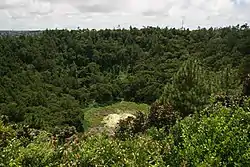 Crater of Trou aux Cerfs | |
| Highest point | |
| Elevation | 605 m (1,985 ft) |
| Coordinates | 20°18′54″S 57°30′18″E |
| Geography | |
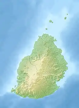 Trou aux Cerfs Location in Mauritius | |
| Location | Curepipe, Mauritius |
| Geology | |
| Mountain type | Dormant - Volcanic crater |
| Climbing | |
| Easiest route | Car/Walking |
The crater was formed less than 2 million years ago in the second phase of volcanic activity that created Mauritius.[3]
According to experts, the volcano is currently dormant but could become active at any time within the next thousand years.
The crater is only accessible down a steep embankment which is considered dangerous. Water and silt have clogged the crater, making it even less accessible.
References
Wikimedia Commons has media related to Trou aux Cerfs.
- "Trou aux Cerfs". Mauritius UK Connection. Retrieved 2007-03-17.
- "Trou aux Cerfs volcano". Government of Mauritius. Archived from the original on 2007-03-07. Retrieved 2007-03-17.
- Scheffel, Richard L.; Wernet, Susan J., eds. (1980). Natural Wonders of the World. United States of America: Reader's Digest Association, Inc. pp. 390. ISBN 0-89577-087-3.
This article is issued from Wikipedia. The text is licensed under Creative Commons - Attribution - Sharealike. Additional terms may apply for the media files.