List of tripoints of U.S. states
This is a list of all tripoints in which the boundaries of three (and only three) U.S. states converge at a single geographic point. Of the 62 such points, 35 are on dry land and 27 are in water.[1] Of the 27 points on water, 3 are in the Great Lakes and thus have no land nearby. A tripoint occurring in a populated area may also be informally described as a tri-state area.
Land
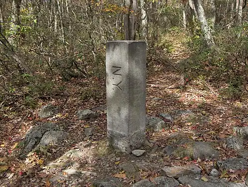 New York–Massachusetts–Connecticut tripoint marker
 Connecticut–Rhode Island–Massachusetts tripoint marker
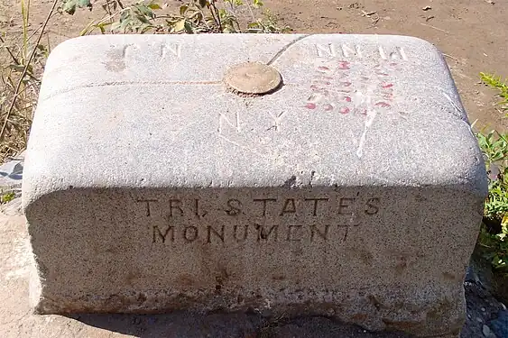
 Indiana–Michigan–Ohio tripoint marker
 Colorado–Kansas–Oklahoma tripoint marker (8 Mile Corner)
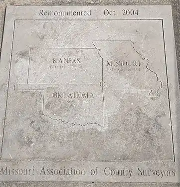 Kansas-Missouri-Oklahoma tripoint marker
| State 1 | State 2 | State 3 | Coordinates | Notes |
|---|---|---|---|---|
| Alabama | Florida | Georgia | 31°0′2″N 85°0′8″W | Marker on Chattahoochee riverbank is actually a few feet above and west of true tripoint at high-water line. |
| Alabama | Georgia | Tennessee | 34°59′5″N 85°36′19″W | Tri-State Corner. Marker on dry land at surface level and unmarked on lake in cavern directly below. Stolen in 2009 and returned two years later.[2][3] |
| Arizona | Nevada | Utah | 37°0′1″N 114°3′2″W | Marked with a red sandstone monument.[4] |
| Arkansas | Louisiana | Mississippi | 33°0′15″N 91°9′58″W | Probably unmarked on silt island in river sometimes connected to west bank by mud flat accreted by riprap. |
| Arkansas | Louisiana | Texas | 33°1′9″N 94°2′35″W | See Ark-La-Tex. Marker in process of being surrounded and absorbed by tree. |
| Arkansas | Missouri | Oklahoma | 36°29′58″N 94°37′5″W | Marked with a stone monument.[5] |
| Arkansas | Oklahoma | Texas | 33°38′16″N 94°29′9″W | Unmarked on seasonal silt island or in river bed, but Oklahoma–Texas state line as revised in 2000 is defective in not extending from vegetation line on south bank to pre-established tripoint. |
| California | Nevada | Oregon | 41°59′40″N 119°59′57″W | Marked with a cairn.[6] |
| Colorado | Kansas | Nebraska | 40°0′11″N 102°3′6″W | Marked with a brass disc.[7] |
| Colorado | Kansas | Oklahoma | 36°59′35″N 102°2′32″W | 8 Mile Corner. Marker is concealed in crypt beneath removable manhole cover. |
| Colorado | Nebraska | Wyoming | 41°0′5″N 104°3′12″W | Marked with a stone surrounded by a three-stone colored base.[8] |
| Colorado | New Mexico | Oklahoma | 37°0′0″N 103°0′8″W | Preston Monument |
| Colorado | Utah | Wyoming | 41°0′2″N 109°3′0″W | Marked.[9] |
| Connecticut | Massachusetts | New York | 42°2′59″N 73°29′14″W | See Brace Mountain or Mount Frissell. Marked with a stone inscribed with MASS-1898-NY and sometimes a "scratched-on" CONN.[10] |
| Connecticut | Massachusetts | Rhode Island | 42°0′29″N 71°47′57″W | See Thompson, Connecticut. Marked with a stone inscribed with MASS-CONN-RI.[11] |
| Delaware | Maryland | Pennsylvania | 39°43′20″N 75°47′19″W | See Delaware Wedge. Marked with a stone inscribed with M-M-P-P, as this was not the original intended tri-point.[12] |
| Georgia | North Carolina | Tennessee | 34°59′18″N 84°19′19″W | Marked.[13] |
| Idaho | Montana | Wyoming | 44°28′27″N 111°2′56″W | Located within Yellowstone National Park. Marked, although difficult to access.[14] |
| Idaho | Nevada | Oregon | 42°0′1″N 117°1′34″W | Marked with a three-sided stone inscribed with N-I-O on the respective faces.[15] |
| Idaho | Nevada | Utah | 41°59′37″N 114°2′30″W | Marked with a granite monument inscribed with the respective states' names.[16] |
| Idaho | Utah | Wyoming | 42°0′6″N 111°2′48″W | Marked with a stone.[17] |
| Indiana | Michigan | Ohio | 41°41′46″N 84°48′22″W | Brass marker with the shapes of the three states is located in a monument box beneath the surface of a rural road. Was set in 1999[18] and is referenced by a granite marker 20 feet to the east on the Michigan-Ohio line.[19] |
| Iowa | Minnesota | South Dakota | 43°30′1″N 96°27′12″W | True point is marked with a disc in the center of a T-shaped road intersection.[20] A witness monument nearby in the South Dakota corner acknowledges the tri-point being set in 1859. |
| Kansas | Missouri | Oklahoma | 36°59′56″N 94°37′5″W | Marked with a plaque on a seldom used dead-end road.[21] |
| Kentucky | Tennessee | Virginia | 36°36′3″N 83°40′32″W | Tri-State Peak[22] Located within Cumberland Gap National Historical Park. Marked. |
| Kentucky | Virginia | West Virginia | 37°32′17″N 81°58′5″W | Marked with a USCG marker on top of a two-foot high iron pipe at the river's high point.[23] |
| Maryland | Pennsylvania | West Virginia | 39°43′16″N 79°28′36″W | Marked with a pyramid-like stone.[24] |
| Massachusetts | New Hampshire | Vermont | 42°43′37″N 72°27′30″W | Marker is technically on dry land, but buried within river bed due to a dam's construction downstream.[25] |
| Massachusetts | New York | Vermont | 42°44′45″N 73°15′54″W | Marked with a stone.[26] |
| Montana | North Dakota | South Dakota | 45°56′43″N 104°2′44″W | Marked with a red granite stone.[27] |
| Montana | South Dakota | Wyoming | 44°59′51″N 104°3′28″W | Marked with a stone within a fence.[28] |
| Nebraska | South Dakota | Wyoming | 43°0′2″N 104°3′11″W | Marked with a stone within a fence.[29] |
| New Jersey | New York | Pennsylvania | 41°21′27″N 74°41′42″W | Marked by the Tri-States Monument in Port Jervis, New York, at the confluence of the Delaware and Neversink rivers.[30][31] |
| New Mexico | Oklahoma | Texas | 36°30′1″N 103°0′9″W | Texhomex Marker |
| North Carolina | Tennessee | Virginia | 36°35′17″N 81°40′39″W | North Carolina–Tennessee–Virginia Corners - Marked.[32] |
Water
See also
- Four Corners Monument – a quadripoint
References
- "Tri State Corners in the United States" (PDF). Jack Parsell.
- Wheatley, Thomas. "Camak Stone, border marker between Tennessee and Georgia, is missing". Creativeloafing.com. Retrieved May 7, 2017.
- Vardeman, Johnny. "Stolen stone returns home minus fanfare". Gainesville Times. Retrieved May 7, 2017.
- "Arizona–Nevada–Utah" (PDF). Bjbsoftware.com. Retrieved August 27, 2018.
- "Arkansas–Missouri–Oklahoma" (PDF). Bjbsoftware.com. Retrieved August 27, 2018.
- "Oregon–California–Nevada" (PDF). Bjbsoftware.com. Retrieved August 27, 2018.
- "Colorado–Nebraska–Kansas" (PDF). Bjbsoftware.com. Retrieved August 27, 2018.
- "Colorado–Nebraska–Wyoming" (PDF). Bjbsoftware.com. Retrieved August 27, 2018.
- "Colorado–Utah–Wyoming" (PDF). Bjbsoftware.com. Retrieved August 27, 2018.
- "Connecticut–Massachusetts–New York". Bjbsoftware.com. Retrieved August 27, 2018.
- "Connecticut–Massachusetts–Rhode Island". Bjbsoftware.com. Retrieved August 27, 2018.
- "Delaware–Maryland–Pennsylvania". Bjbsoftware.com. Archived from the original on March 19, 2002. Retrieved August 27, 2018.
- "Georgia–North Carolina–Tennessee" (PDF). Bjbsoftware.com. Retrieved August 27, 2018.
- "Idaho–Montana–Wyoming" (PDF). Bjbsoftware.com. Retrieved August 27, 2018.
- "Idaho–Nevada–Oregon" (PDF). Bjbsoftware.com. Retrieved August 27, 2018.
- "Idaho–Nevada–Utah" (PDF). Bjbsoftware.com. Retrieved August 27, 2018.
- "Idaho–Utah–Wyoming" (PDF). Bjbsoftware.com. Retrieved August 27, 2018.
- "Jack Parsell's description of the IN-MI-OH tripoint" (PDF). Bjbsoftware.com. Retrieved August 27, 2018.
- "Geocaching – The Official Global GPS Cache Hunt Site". Geocaching.com. Retrieved August 27, 2018.
- "Photo by Gregg A. Butler of the IA-MN-SD tripoint and its witness post" (JPG). Bjbsoftware.com. Retrieved August 27, 2018.
- "Kansas–Missouri–Oklahoma". Bjbsoftware.com. Retrieved August 27, 2018.
- "KY-TN-VA Tri-State Peak at Cumberland Gap National Historical Park". Nps.gov. Retrieved April 1, 2018.
- "Kentucky–Virginia–West Virginia" (PDF). Bjbsoftware.com. Retrieved August 27, 2018.
- "Maryland–Pennsylvania–West Virginia" (PDF). Bjbsoftware.com. Retrieved August 27, 2018.
- Eric Jones. New Hampshire Curiosities. Globe Pequot, 2006. p. 114-5
- "Massachusetts–New York–Vermont". Bjbsoftware.com. Retrieved August 27, 2018.
- "Montana–North Dakota–South Dakota" (PDF). Bjbsoftware.com. Retrieved August 27, 2018.
- "Montana–South Dakota–Wyoming" (PDF). Bjbsoftware.com. Retrieved August 27, 2018.
- "Nebraska–South Dakota–Wyoming" (PDF). Bjbsoftware.com. Retrieved August 27, 2018.
- "New York–Pennsylvania–New Jersey Tristate" (PDF). Bjbsoftware.com. Retrieved January 14, 2019.
- Graff, Bill (Summer 2006). "Sentinels at the Northern Border" (PDF). Unearthing New Jersey. New Jersey Geological Survey. 2 (2): 1–3.
Tri-States Monument ... this small granite slab serves as both the northern end of our boundary with Pennsylvania and the northwestern end with New York.
- "North Carolina–Tennessee–Virginia" (PDF). Bjbsoftware.com. Retrieved August 27, 2018.
- "Iowa–Minnesota–Wisconsin". Bjbsoftware.com. Retrieved August 27, 2018.
External links
Wikimedia Commons has media related to U.S. state tripoints.
- Tripoint Guide
- Clark, Patterson; Lu, Denise (September 17, 2015). "Cornering America's tri-points". The Washington Post. Retrieved October 5, 2016.
This article is issued from Wikipedia. The text is licensed under Creative Commons - Attribution - Sharealike. Additional terms may apply for the media files.