Top Points railway station
Top Points is a railway station on the Zig Zag Railway (heritage railway) in the Blue Mountains area of New South Wales.
Top Points | |||||||||||
|---|---|---|---|---|---|---|---|---|---|---|---|
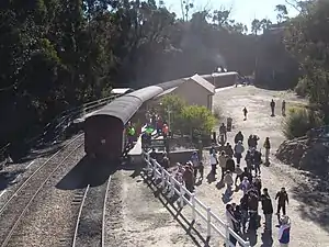 Northbound view in July 2006 | |||||||||||
| General information | |||||||||||
| Location | Lithgow | ||||||||||
| Elevation | 1,025 metres | ||||||||||
| Line(s) | Zig Zag Railway | ||||||||||
| Platforms | 2 side | ||||||||||
| Tracks | 2 | ||||||||||
| Construction | |||||||||||
| Structure type | Ground | ||||||||||
| Other information | |||||||||||
| Website | Top Points | ||||||||||
| History | |||||||||||
| Opened | 18 October 1975 | ||||||||||
| Services | |||||||||||
| |||||||||||
It is situated at the reversal point of the Middle and Top Roads of the Lithgow Zig Zag. When the Zig Zag Railway reopened in October 1975, Top Points was a terminal station on the line. It originally consisted of a platform on the western side with the eastern platform constructed after the line was extended to Clarence. The area behind the eastern platform was a carpark.
In 2002, the former Cooerwull station footbridge was added to join the two platforms.[1][2]
References
This article is issued from Wikipedia. The text is licensed under Creative Commons - Attribution - Sharealike. Additional terms may apply for the media files.