Tierra Caliente (Mexico)
Tierra Caliente (Spanish for Hot Land) is a cultural and geographical region in southern Mexico that comprises some low-elevation areas of the states of Michoacán, Guerrero and Mexico. As the name suggests, the region is characterized by a hot climate. The overall precipitation is also low - around 600 mm/year, but can be as low as 400 mm in some low-lying areas of Michoacán and Guerrero.
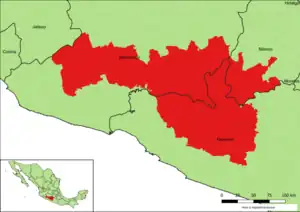
Map showing the Tierra Caliente region
Municipalities
Guerrero
| Name | Municipal seat | |||||||||||||
|---|---|---|---|---|---|---|---|---|---|---|---|---|---|---|
| Ajuchitlán del Progreso | Ajuchitlán | |||||||||||||
| Arcelia | Arcelia | |||||||||||||
| Coyuca de Catalán | Coyuca de Catalán | |||||||||||||
| Cutzamala de Pinzón | Cutzamala de Pinzón | |||||||||||||
| San Miguel Totolapan | San Miguel Totolapan | |||||||||||||
| Tlalchapa | Tlalchapa | |||||||||||||
| Tlapehuala | Tlapehuala | |||||||||||||
| Zirándaro | Zirándaro de los Chávez | |||||||||||||
| [[Cuidad Altamirano | (municipality) | Cuidad Altamirano Pungarabato
State of Mexico
SourcesReferences
|
This article is issued from Wikipedia. The text is licensed under Creative Commons - Attribution - Sharealike. Additional terms may apply for the media files.