Thakle
{{Infobox settlement
|name = Thakle
|other_name =
|native_name = थाक्ले
|nickname =
|settlement_type = [[Manebhanjyang Rural Municipality,ward No.6)]
|motto =
|image_skyline =
|image_caption =
|image_flag =
|image_seal =
|image_map =
|mapsize =
|map_caption =
|pushpin_map = Nepal
|pushpin_label_position = bottom
|pushpin_mapsize = 300
|pushpin_map_caption = Location in Nepal
|subdivision_type = Country
|subdivision_name = ![]() Nepal
|subdivision_type1 = Zone
|subdivision_name1 = Sagarmatha Zone
|subdivision_type2 = District
|subdivision_name2 = Okhaldhunga District
|government_footnotes =
|government_type =
|leader_title =
|leader_name =
|leader_title1 =
|leader_name1 =
|established_title =
|established_date =
|unit_pref =
|area_footnotes =
|area_total_km2 =
|area_total_sq_mi =
|population_as_of = 1991
|population_footnotes =
|population_note =
|population_total = 2336
|population_density_km2 = auto
|population_blank1_title = Ethnicities
|timezone = Nepal Time
|utc_offset = +5:45
|timezone_DST =
|utc_offset_DST =
|coordinates = 27.17°N 86.45°E
|elevation_footnotes =
|elevation_m =
|postal_code_type =
|postal_code =
|area_code =
|blank_name =
|blank_info =
|website =
|footnotes =
}}
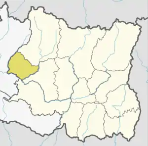
Thakle is a village development committee in Okhaldhunga District in the Sagarmatha Zone of mid-eastern Nepal. At the time of the 1991 Nepal census it had a population of 2336 living in 390 individual households.[1]
Nepal
|subdivision_type1 = Zone
|subdivision_name1 = Sagarmatha Zone
|subdivision_type2 = District
|subdivision_name2 = Okhaldhunga District
|government_footnotes =
|government_type =
|leader_title =
|leader_name =
|leader_title1 =
|leader_name1 =
|established_title =
|established_date =
|unit_pref =
|area_footnotes =
|area_total_km2 =
|area_total_sq_mi =
|population_as_of = 1991
|population_footnotes =
|population_note =
|population_total = 2336
|population_density_km2 = auto
|population_blank1_title = Ethnicities
|timezone = Nepal Time
|utc_offset = +5:45
|timezone_DST =
|utc_offset_DST =
|coordinates = 27.17°N 86.45°E
|elevation_footnotes =
|elevation_m =
|postal_code_type =
|postal_code =
|area_code =
|blank_name =
|blank_info =
|website =
|footnotes =
}}
Thakle is a village development committee in Okhaldhunga District in the Sagarmatha Zone of mid-eastern Nepal. At the time of the 1991 Nepal census it had a population of 2336 living in 390 individual households.[1]
References
- "Nepal Census 2001", Nepal's Village Development Committees, Digital Himalaya, retrieved 15 November 2009.