Taurion
The Taurion (French pronunciation: [toʁjɔ̃]; Occitan: Taurion), as it is known in Haute-Vienne, or Thaurion, as it is known in Creuse, is a 107.5 km long river in western France, tributary of the Vienne river.[1]
| Taurion | |
|---|---|
 | |
  | |
| Location | |
| Country | France |
| Physical characteristics | |
| Source | |
| • location | Limousin |
| • elevation | 785 m (2,575 ft) |
| Mouth | |
• location | Vienne |
• coordinates | 45°53′3″N 1°23′40″E |
• elevation | 232 m (761 ft) |
| Length | 107.5 km (66.8 mi) |
| Basin size | 1,030 km2 (400 sq mi) |
| Discharge | |
| • average | 18.9 m3/s (670 cu ft/s) at Saint-Priest-Taurion |
| Basin features | |
| Progression | Vienne→ Loire→ Atlantic Ocean |
Its source is at an altitude of 785 m on the Plateau de Millevaches, on the flanks of the Puy de Groscher, near Gentioux in the commune of Gentioux-Pigerolles, in the Creuse département.
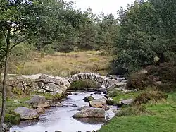
It passes under the bridge of Sénoueix, feeds the Lac de Lavaud-Gelade, and then crosses the Rigole du diable. It flows into the Vienne on the right bank at Saint-Priest-Taurion, at 232 m elevation. Hydro-electric dams are built along the river, (La Roche Talamy, l'Étroit, Saint-Marc, Chauvan).
The Taurion flows through the following départements and towns: