Tagil
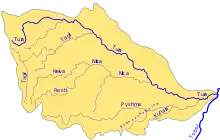
The Tagil (Russian: Тагил) is a river in Sverdlovsk Oblast, Russia. It is 414 kilometres (257 mi) long, with a drainage basin of 10,100 square kilometres (3,900 sq mi). The average discharge is 40 cubic metres per second (1,400 cu ft/s).[1] The river has its sources on the eastern slopes of the Ural Mountains, east of Verkhny Tagil. From there, the Tagil flows north towards Nizhny Tagil, and then in a northeasterly direction to its confluence with the Tura.
| Tagil | |
|---|---|
.JPG.webp) | |
 Tura basin | |
| Location | |
| Country | Russia |
| Physical characteristics | |
| Mouth | Tura |
• coordinates | 58.5297°N 62.4772°E |
| Length | 414 km (257 mi) |
| Basin size | 10,100 km2 (3,900 sq mi) |
| Basin features | |
| Progression | Tura→ Tobol→ Irtysh→ Ob→ Kara Sea |
The Salda is a southern tributary. A northern tributary, the Barancha, was probably used by Yermak Timofeyevich on his way to capture the Khanate of Sibir.
References
- "Река Тагил in the State Water Register of Russia". textual.ru (in Russian).
This article is issued from Wikipedia. The text is licensed under Creative Commons - Attribution - Sharealike. Additional terms may apply for the media files.