Taiz Governorate
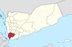
Taiz (Arabic: تَعِزّ, romanized: Taʿizz) is a governorate of Yemen. The governorate's capital is Taiz, which is the third-largest city in Yemen. Today it is among the most important commercial centres in Yemen, owing to its proximity to rich farmland in the nation and to the important Red Sea port of Mocha. It also has an international airport, Taiz International Airport, with numerous services within Yemen and to neighbouring countries.
Taiz
محافظة تَعِزّ | |
|---|---|
Governorate | |
_(cropped).jpg.webp) | |
 | |
| Coordinates: 13°34′N 44°01′E | |
| Country | |
| Region | Janad Region |
| Seat | Taiz |
| Government | |
| • Governor | Amin Ahmed Mahmoud[1] |
| Area | |
| • Total | 12,605 km2 (4,867 sq mi) |
| Population (2011)[2] | |
| • Total | 2,885,000 |
| • Density | 230/km2 (590/sq mi) |
Geography
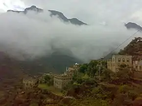
For such a small area, Taiz Governorate has an extraordinarily diverse geography. The western half of the governorate is part of the Tihamah coastal plain and has an exceedingly hot, humid and arid climate. The eastern half, however, is very mountainous, with the major peak being 3,070-metre-high Jabal Sabir, near Taiz city. These mountains trap the moisture created by an upper-level wind reversal between April and October, so that in the eastern half of the governorate annual rainfall increases from 200 millimetres (8 inches) in the foothills to probably more than 1,000 millimetres (40 inches) near Jebel Saber. Temperatures in the highlands remain high during the daytime, but at the highest elevations they can fall dramatically to -5 °C (23 °F) overnight.
Mountain ranges
The governorate has many mountains. Their height ranges between 1,000 and 3,200 metres. The most important mountains are Jabal Sabir, Jabal Habashi, Jabal Samaʿa, Jabal Qadas, Jabal As-Silw, the mountains of al-Wazi'iyah and the Mountains of Shar'ab and Maqbanah.[3][4]
Streams
There are many streams in Taiz governorate; known as wadi (Arabic: وادي), they are divided into perennial and temporary streams:[3]
Perennial streams
- Wadi Rasian, it is located in Mawza, Shara'b Ar Rawnah, al-Makha and Maqbanah.
- Wadi Warzan, it is located in Khadir and al-Mawasit.
- Wadi al-Dhabab, it is located in al-Mawasit and Hayfan.
- Wadi Ar-Ram, it is located in al-Mafalis region, Hayfan.
- Wadi al-Dhabab, it is located in Sabir al-Mawadim.
- Wadi al-Ashroh also known as Wadi al-Barakani, is located in al-Mawasit.
- Wadi al-Janah, is located in al-Wazi'iyah.
- Wadi al-Lahya, is located in Mawza.
Temporary streams
Are the steams that only run in wet seasons:[3]
| Districts | Temporary streams |
|---|---|
| Damnt Khadir | Wadi al-Shofiah |
| Mawaiah | Wadi al-Sudan, Wadi al-Gharman, Wadi al-Sawarih |
| As-Silw | Wadi Qoradah, Wadi al-Zubirah, Wadi al-Qatriah |
| Hayfan | Wadi al-Musali, Wadi Khawalah, Wadi Shawkah |
| Ash-Shamayatayn | Wadi Adim |
| Shar'ab Ar-Rawnah | Wadi Gaw'ah, Wadi al-Ma', Wadi Shamlah |
| Shar'ab As-Salam | Wadi al-fojeer, Wadi al-Habab, Wadi Hawsa', Wadi Nakhlah |
| Jabal Habashi | Wadi Hannah |
| al-Makha | Wadi Tanag, Wadi Kabir, Wadi Hathiah |
| At-Ta'iziyah | Wadi Haban |
| Sabir al-Mawadim | Wadi Sailat Hawas |
| Al-wazyiah | Wadi al-Makhshab, Wadi al-Mu'aqam, Wadi Hawlajah, Wadi Sumadah |
| Mawza | Wadi Janob, Wadi al-Gharafi, Wadi al-Majash, Wadi Hagharamah, Wadi al-Murra, Wadi Sha'bo |
Adjacent governorates
- Al Hudaydah Governorate (north)
- Ibb Governorate (north)
- Dhale Governorate (northeast)
- Lahij Governorate (southeast)
Districts

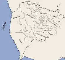
Taiz Governorate is divided into the following 23 districts. These districts are further divided into sub-districts, and then further subdivided into villages:
- Al Mukha District
- Al Ma'afer District
- Al Mawasit District
- Al Misrakh District
- Al Mudhaffar District
- Al Qahirah District
- Al Wazi'iyah District
- As Silw District
- Ash Shamayatayn District
- At Ta'iziyah District
- Dhubab District
- Dimnat Khadir District
- Hayfan District
- Jabal Habashy District
- Maqbanah District
- Mashra'a Wa Hadnan District
- Mawiyah District
- Mawza District
- Sabir Al Mawadim District
- Salh District
- Sama District
- Shara'b Ar Rawnah District
- Shara'b As Salam District
Economy
The agriculture of this governorate is diverse. In the Tihamah region, there is only irrigated agriculture, with cotton, sorghum and sesame the chief crops. Inland, whilst these crops are still significant, a much wider range of crops can be grown on rainfall and through water storage. Mangoes, papayas and bananas are the major crops of the western escarpment, and further up coffee and khat are grown. Although wine is prohibited in Yemen because of its alcohol content, grapes are still grown to produce raisins in some areas.
Wildlife
The governorate has many wild animals and birds. The most common wild animals in the governorate are hyaenas, foxes, tigers, lions, rock hyrax, african wild dog, rabbits, hedgehog, monkeys. The most common wild birds are vultures, falcons, partridges, owls, pigeons, hoopoes, bulbuls.[3]
Regions


- Shamir: (Arabic: شمير) also called "Shamir Maqbanah". It is a mountainous region part of Maqbanah district.
- Al-Hugariyyah: (Arabic: الحجرية) It is the largest region in Taiz governorate. It is sometimes mistakenly called al-Hujariah district. The region is part of As-Silw, al-Ma'afer, Hayfan, Sama', al-Mawasit, Jabal Habashy, Dimnat Khadir, and al-Wazi'iyah districts.
Islands
References
- "Yemeni president appoints five new ministers in cabinet reshuffle". 24 December 2017.
- "Statistical Yearbook 2011". Central Statistical Organisation. Retrieved 24 February 2013.
- "نبذة تعريفية عن محافظة تعز". NIC (National Information Center of Yemen) (in Arabic). Retrieved 2019-06-19.
- Scoville, Sheila A. (1979). Gazetteer of Arabia: a geographical and tribal history of the Arabian Peninsula. Akademische Druck- u. Verlagsanstalt. p. 173. ISBN 9783201016254.
External links
![]() Media related to Taiz Governorate at Wikimedia Commons
Media related to Taiz Governorate at Wikimedia Commons