Tō-no-Hetsuri
Bridge of Tō-no-Hetsuri
_14_Feb%252C_2015_-_panoramio.jpg.webp)
Bridge of Tō-no-Hetsuri in snow
.jpg.webp)
Cliff face of Tō-no-Hetsuri
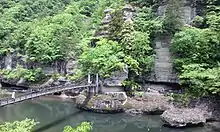
Tō-no-Hetsuri (塔のへつり, lit. "tower cliffs overlooking a river") is a 200 metre long natural cliff formation located in Ōkawa Hatori Prefectural Park in Shimogō in Fukushima, Japan.
History
The name Hetsuri comes from the local Aizu word for "cliff overlooking a river".[1]
The area was designated a natural monument in 1943 as a unique example of terrain formed during the Pleistocene epoch.[2] The cliff sides were carved out by the Agano River (known as the Ōkawa River in Fukushima Prefecture) over hundreds of years.
Today, the area is a popular sightseeing spot in Fukushima Prefecture.
Transportation
- Aizu Railway Aizu Line, Tō-no-Hetsuri Station - a 10 minutes walk from the station.
- Japan National Route 121
See also
References
- "To no Hetsuri". www.tif.ne.jp. Retrieved 2015-11-16.
- OYAGI, Norio (2003-07-01). "Examples of spread type landslides in Japan". Annual Report. 4: 133–153.
External links
Wikimedia Commons has media related to Tō-no-Hetsuri.
- Tō-no-Hetsuri, Shimogo-town Tourism Association (Japanese)
This article is issued from Wikipedia. The text is licensed under Creative Commons - Attribution - Sharealike. Additional terms may apply for the media files.