Sulzfluh
The Sulzfluh is a mountain in the Rätikon range of the Alps, located on the border between Austria and Switzerland. The closest locality is St. Antönien, on the southern side.
| Sulzfluh | |
|---|---|
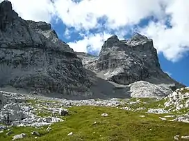
 Sulzfluh, from the northwest. | |
| Highest point | |
| Elevation | 2,817 m (9,242 ft) |
| Prominence | 475 m (1,558 ft)[1] |
| Parent peak | Drusenfluh |
| Isolation | 2.6 km (1.6 mi) |
| Listing | Alpine mountains 2500-2999 m |
| Coordinates | 47°0′45.4″N 9°50′21.7″E |
| Geography | |
 Sulzfluh Location in the Alps | |
| Location | Graubünden, Switzerland Vorarlberg, Austria |
| Parent range | Rätikon |
| Climbing | |
| First ascent | 1782 |
| Easiest route | Mountain path on eastern face |
It is well known by climbers and has a Via ferrata on the southern, Swiss face, in Graubünden. There are a total of six known caves into the limestone mountain, with lengths between 800 and 3000 or more yards, with all entrances on the Eastern side, in Switzerland.[2]
The eastern side has a mountain path of grade T4,[3] allowing non-climbers to reach the 2817 metre summit. This is part of a multi day walking route along the entire length of the Rätikon chain on the sunnier side, called "Prättigauer Höhenweg".[4]

Sulzfluh on the northern (Austrian) side.
References
- Retrieved from the Swisstopo topographic maps. The key col is the Drusator (2,342 m).
- Biological report about Cave bear in the caves. (german)
- (in English) Hiking in Switzerland, degree of difficulty
- (in English) Hiking Switzerland past Sulzfluh, Graubünden Archived 2014-08-18 at the Wayback Machine
This article is issued from Wikipedia. The text is licensed under Creative Commons - Attribution - Sharealike. Additional terms may apply for the media files.