Sullivan Square station
Sullivan Square station is a rapid transit station on the MBTA subway Orange Line, located adjacent to Sullivan Square in the Charlestown neighborhood of Boston, Massachusetts. It is a major transfer point for MBTA bus service, with 13 routes using a two-level busway. The station has two island platforms serving the two active Orange Line tracks plus an unused third track. The Haverhill Line and Newburyport/Rockport Line pass through the station on separate tracks but do not stop.
Sullivan Square | |||||||||||||||||||||
|---|---|---|---|---|---|---|---|---|---|---|---|---|---|---|---|---|---|---|---|---|---|
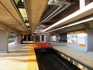 A northbound train at Sullivan Square station in July 2019 | |||||||||||||||||||||
| General information | |||||||||||||||||||||
| Location | Maffa Way and Cambridge Street Charlestown, Boston, Massachusetts | ||||||||||||||||||||
| Coordinates | 42.384031°N 71.07697°W | ||||||||||||||||||||
| Line(s) | Haymarket North Extension | ||||||||||||||||||||
| Platforms | 2 island platforms | ||||||||||||||||||||
| Tracks | 3 (Orange Line) 2 (commuter rail) | ||||||||||||||||||||
| Connections | |||||||||||||||||||||
| Construction | |||||||||||||||||||||
| Parking | 222 spaces ($6.00 fee) | ||||||||||||||||||||
| Bicycle facilities | 16 spaces | ||||||||||||||||||||
| Accessible | Yes | ||||||||||||||||||||
| History | |||||||||||||||||||||
| Opened | June 10, 1901 (elevated station) | ||||||||||||||||||||
| Rebuilt | April 7, 1975 (modern station)[1] | ||||||||||||||||||||
| Passengers | |||||||||||||||||||||
| FY2019 | 8,305 (weekday average boardings)[2] | ||||||||||||||||||||
| Services | |||||||||||||||||||||
| |||||||||||||||||||||
| |||||||||||||||||||||
| |||||||||||||||||||||
| Location | |||||||||||||||||||||
The Boston and Maine Railroad (B&M) opened through Sullivan Square in 1845, followed by the Eastern Railroad in 1854; both railroad had stations there. The B&M acquired the Eastern in 1885 and combined their stations as part of a grade crossing elimination project in 1900–01. That station served commuter trains until 1958. The Boston Elevated Railway opened its Sullivan Square station in June 1901 as the northern terminus of the Charlestown Elevated. The massive terminal served numerous streetcar lines as well as elevated trains.
The modern station opened in May 1975 as part of the Haymarket North Extension, which replaced the Charlestown Elevated; the old terminal was demolished the next year. Sullivan Square station was made accessible in the 1990s, and the busways were reconfigured in 2018–2019.
Station layout
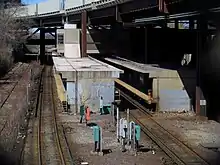
Sullivan Square station is located in an open cut under the Interstate 93 viaduct just west of the Sullivan Square traffic circle. The cut has seven tracks: two freight yard tracks (Yard 21, with the tracks called 3rd Iron and 4th Iron) on the west, three Orange Line rapid transit tracks in the center, and two tracks used by MBTA Commuter Rail Haverhill Line and Newburyport/Rockport Line trains on the east.[3][4][5] Only the west (southbound) and center (northbound) Orange Line tracks are used for revenue service; the unused east track, originally intended for express service, is only used for maintenance and testing. A pair of island platforms are located between the Orange Line tracks; the west platform serves trains in both directions, while the east platform serves only northbound trains.[4]
The platforms have a "utilitarian" concrete design similar to Community College station.[6]: 100 A mezzanine and fare lobby above the tracks is connected to the platforms with stairs, escalators, and elevators. The entrance is from the east side of the tracks, on the upper level of the two-level busway.[7][8] East of the busways is a surface parking lot.[8]
The busway has two lanes on the lower level and one on the upper level. A passageway leads from outside the station entrance under the upper busway to the lower busway.[8] Sullivan Square is a major MBTA bus terminal, serving routes 86, 89, 90, 91, 92, 93, 95, 101, 104, 105, 109, and CT2.[9]
| 3rd Iron | ← Freight use only → |
| 4th Iron | ← Freight use only → |
| Southbound (Track 1) | ← Orange Line toward Forest Hills (Community College) |
| Island platform | |
| Northbound (Track 2) | Orange Line toward Oak Grove (Assembly) → |
| Island platform | |
| Track 3 | No regular service |
| Commuter Rail (Track 2) | ← Haverhill Line, Newburyport/Rockport Line do not stop here → |
| Commuter Rail (Track 1) | ← , Haverhill Line, Newburyport/Rockport Line do not stop here → |
History
Railroad stations
The Boston and Maine Railroad (B&M) opened its new mainline just west of Sullivan Square on July 1, 1845. The parallel Grand Junction Railroad and Depot Company opened in 1849; passenger service on that line began on April 10, 1854 as the Eastern Railroad's entrance to Boston.[10]: 75 Both railroads opened stations at Sullivan Square, both variously known as Somerville and East Somerville, with the beginning of passenger service or soon after. (While the stations were in Charlestown, they primarily served nearby Somerville.[11][12] By 1875, the B&M station was located on the north side of Cambridge Street, with the Eastern station on the south side.[13][14] The B&M acquired the Eastern in 1885 and initially continued to use both stations.[15][10]: 75
The wide grade crossing of Cambridge Street was a perennial safety issue, with 677 trains crossing the street each day.[16] When electric streetcars were added on the street in 1895, they had to detour via neighborhood streets to use the Main Street (Broadway) bridge.[17] In October 1895, the Massachusetts Superior Court issued orders to eliminate remaining grade crossings in Charlestown.[18] Initial plans in 1896 called for Cambridge Street and Perkins Street to be cut at the tracks, with Brighton Street extended to Main Street, but this was unpopular with residents.[19]
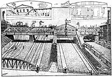
Construction began in mid-1900 on a more popular solution: Cambridge Street was raised onto a bridge over the tracks, Perkins Street was cut, with a footbridge in its place.[16][20] As part of the project, the B&M constructed a new East Somerville station to replace the older stations.[21] The station building was located over the tracks on the north side of Cambridge Street; two island platforms were reached by stairs from the station building and from the Perkins Street footbridge.[22][23] The station opened for suburban traffic by June 1901, while the Cambridge Street bridge was completed that July.[21]
The station building was closed in 1927 as short-distance passenger traffic declined, and was soon demolished. In February 1932, with just a few trains a day stopping, the railroad successfully petitioned the Public Utilities Commission to abandon the station entirely.[24][25] However, the station remained in use, served by a small number of trains on both the Eastern Division and Western Division.[26] On April 18, 1958, the Boston and Maine Railroad received permission from the Public Utilities Commission to drastically curtail its suburban commuter service, including abandoning branches, closing stations, and cutting trains. Among the approved cuts was the closure of all Eastern Division service south of Lynn, including the Saugus Branch plus mainline stations at East Somerville, Everett, Chelsea, and Forbes.[27] The Saugus Branch and mainline stations were closed on May 16, 1958.[10][28]
Elevated station
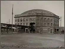
The first rapid transit station at Sullivan Square opened on June 10, 1901 as part of the Charlestown Elevated rapid transit line, a predecessor to the modern Orange Line. The original elevated station was considered a crown jewel of the "El", along with a similar station complex at Dudley Square in Roxbury. The steel-and-brick structure was designed by Alexander Wadsworth Longfellow Jr. along with the other original elevated stations.[29] It was a polygonal shape about 175 feet (53 m) square, with a glass trainshed spanning an open interior.[30] Sullivan Square and its station are named for James Sullivan, an early 19th-century Governor of Massachusetts and first president of the Middlesex Canal Company.
The station was designed as a major transfer point, with many streetcar lines that had formerly gone downtown truncated to Sullivan. Surface streetcars ran up a ramp to ten stub-end tracks at the level of the elevated stations, allowing cross-platform transfers with elevated trains; lines not terminating at Sullivan used a surface-level loop.[31]: 21 Lexington and Boston Street Railway cars from as far away as Lowell ran to Sullivan Square until May 4, 1912, when they were redirected to Harvard station.[32] The 1912-built upper-level streetcar loop was demolished and rebuilt beginning on October 13, 1946, to handle new trackless trolleys. Streetcar lines continued to serve the station until the Fellsway Line was converted to bus in December 1955.[33]
Over time, deferred maintenance on the Charlestown Elevated and Sullivan Square station took its toll. A large fire also caused significant damage to the station's upper level on November 1, 1967, and the rail bending shop nearby was destroyed by a fire on January 4, 1975.[34][35] The Charlestown Elevated closed on April 4, 1975.
By June 1975, some local officials and preservationists sought to preserve and renovate the old elevated station for commercial or recreational use.[36] The MBTA issued a $387,000 contract for demolition of the Charlestown Elevated on June 11, 1975, but the $76,000 demolition of Sullivan Square was placed on hold for 45 days for city and state agencies to propose reuse.[37] This deadline was later delayed to November.[38] The station was ultimately demolished beginning in March 1976.[39]
Modern station
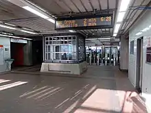
The Haymarket North Extension was constructed in the early 1970s along the Haverhill Line right-of-way, with a relocated new Sullivan Square station under the elevated I-93 expressway. The Haymarket North Extension opened as far as Sullivan Square on April 7, 1975. The new Sullivan station was the terminus of the extension for five months until Wellington opened on September 6, 1975.[1]
Sullivan station was not originally accessible. Construction of elevators at Sullivan and Wellington took place in 1991–92.[40][41][42] In 2002, as part of its public art program, the MBTA added panels with artworks by local schoolchildren at Sullivan Square and Malden Center.[43][44] The concrete walls of the station trench are frequently covered by large graffiti works.[45]
A 2018–2019 construction project, funded as part of environmental mitigation of the new Encore Boston Harbor casino, reconfigured Sullivan Square roadways and the station busways. The lower busway was divided into two lanes, and a new exit to Cambridge Street was added at the south end of the busways. Three short sections of bus-only turn lane on Beacham Street, Maffa Way, and Main Street were added for buses entering the station.[46][47] Repairs to the platforms and canopies were bid in 2018 and completed in 2021.[48][49] The entire Orange Line, including Sullivan Square station, was closed from August 19 to September 18, 2022, during maintenance work.[50]
Plans
Sullivan Square was a proposed stop on the Urban Ring – a circumferential bus rapid transit (BRT) line designed to connect the existing radial MBTA rail lines to reduce overcrowding in the downtown stations.[51] Under draft plans released in 2008, Urban Ring buses would have used the existing bus loop, and a new platform would be built to serve the Haverhill and Newburyport/Rockport commuter rail lines.[52] The project was cancelled in 2010[53]
A $10.5 million design contract for accessibility improvements at Arlington, North Station, and Sullivan Square was awarded in April 2020.[54][55] The MBTA planned to add three elevators to the station, including an elevator to the lower busway. The work would also include replacement of the existing elevators, and two footbridges to connect the new elevators.[55] Design reached 30% in 2021; by that time, the project scope had been reduced to remove the two new platform elevators and footbridges, leaving only the elevator replacements plus the new busway elevator.[56] Design work was expected to reach 75% completion in 2022, but this did not occur.[54][57]
A 2013 city study called for air rights development, including parking garages and retail plus possible commercial structures, over the station parking lot and busways.[58]
References
- Belcher, Jonathan. "Changes to Transit Service in the MBTA district" (PDF). Boston Street Railway Association.
- "A Guide to Ridership Data". MassDOT/MBTA Office of Performance Management and Innovation. June 22, 2020. p. 7.
- Held, Patrick R. (2010). "Massachusetts Bay Colony Railroad Track Charts" (PDF). Johns Hopkins Association for Computing Machinery. p. 9. Archived from the original (PDF) on October 8, 2013.
- "Ridership and Service Statistics" (PDF) (14th ed.). Massachusetts Bay Transportation Authority. 2014.
- "Figure II-4". Final Environmental Impact Statement: Red Line Extension – Harvard Square to Arlington Heights. Vol. 1. Urban Mass Transportation Administration. 1977 – via Internet Archive.
- Elder, Andrew; Fox, Jeremy C. (2013). Boston's Orange Line. Arcadia Publishing. ISBN 9781467120470.
- "Sullivan Square Busway and Parking Lot Reconstruction". Massachusetts Bay Transportation Authority. 2019.
- "Sullivan Square Traffic Improvements" (PDF). Massachusetts Bay Transportation Authority.
- "System Map". Massachusetts Bay Transportation Authority. Retrieved July 29, 2023.
- Humphrey, Thomas J.; Clark, Norton D. (1985). Boston's Commuter Rail: The First 150 Years. Boston Street Railway Association. p. 77. ISBN 9780685412947.
- Barrett, Richard C. (1996). Boston's Depots and Terminals. Railroad Research Publications. pp. 211, 213. ISBN 1884650031.
- Karr, Ronald Dale (2017). The Rail Lines of Southern New England (2 ed.). Branch Line Press. pp. 289, 313. ISBN 9780942147124.
- "Plate L: Part of Ward 22, Boston". Atlas of the county of Suffolk, Massachusetts. Vol. 6. G.M. Hopkins & Co. 1875. pp. 52, 53 – via Norman B. Leventhal Map Center.
- "Plate F: Part of Ward 4, Charlestown". Atlas of the city of Boston. Vol. 6. G.W. Bromley & Co. 1885 – via Norman B. Leventhal Map Center.
- "Plates 19–20". Atlas of the City of Boston. Vol. 10. G.W. Bromley & Co. 1892 – via Norman B. Leventhal Map Center.
- "Removing Grade Crossings". Boston Globe. June 7, 1900. p. 9 – via Newspapers.com.
- "Union Square Electrics". Boston Globe. August 9, 1895. p. 7 – via Newspapers.com.
- "They Must Go". Boston Globe. October 2, 1895. p. 7 – via Newspapers.com.
- "Not Pleased". Boston Globe. February 20, 1896. p. 5 – via Newspapers.com.
- "Needed Change at East Somerville". Boston Globe. July 30, 1900. p. 6 – via Newspapers.com.
- "Will Be Ready For Use Next Month". Boston Globe. June 14, 1901. p. 3 – via Newspapers.com.
- "Plate 19: Part of Ward 4, Charlestown". Atlas of the city of Boston: Charlestown. G.W. Bromley & Co. 1901 – via Norman B. Leventhal Map Center.
- "East Somerville station, Somerville Mass. looking towards Boston". Harry A. Frye Collection. Boston & Maine Railroad Historical Society. c. 1910.
- "B. & M. WANTS TO ABANDON STATIONS: One at East Somervile in List of Three". Daily Boston Globe. February 12, 1932. p. 20 – via Newspapers.com.

- "Authority to abandon East Somerville station". Daily Boston Globe. March 26, 1932. p. 2 – via Newspapers.com.

- Form 5: Haverhill–Lawrence–Boston (timetable), Boston and Maine Railroad, July 8, 1956
- "Drastic Service Cuts Approved on Five B.& M. Divisions". Daily Boston Globe. 19 April 1958. p. 11 – via Newspapers.com.

- "B.&M. Closes Saugus Branch, 3 Other Lines". Daily Boston Globe. May 17, 1958. p. 3 – via Newspapers.com.

- Floyd, Margaret Henderson (1994). Architecture After Richardson: Regionalism Before Modernism--Longfellow, Alden, and Harlow in Boston and Pittsburgh. University of Chicago Press. pp. 369, 370. ISBN 9780226254104.
- "The Sullivan Square Station, Boston". The Engineering Record. Vol. 43, no. 24. June 15, 1901. pp. 575–577 – via HathiTrust.
- Cudahy, Brian J. (1972). Change at Park Street Under: The Story of Boston's Subways. Brattleboro, Vermont, US: Stephen Greene Press. ISBN 0-8289-0173-2.
- "Change in Car Route". Boston Globe. May 3, 1912. p. 1 – via Newspapers.com.

- "This Time In History". Rollsign. Vol. 58, no. 9/10. Boston Street Railway Association. September–October 2021. p. 14. ISSN 0035-7898.
- "This Time in History". Rollsign. Vol. 54, no. 11/12. Boston Street Railway Association. November–December 2017. p. 15.
- "Blaze destroys MBTA rail shop at Sullivan Sq". Boston Globe. January 5, 1975. p. 22 – via Newspapers.com.
- Yudis, Anthony J. (June 1, 1975). "'Stay' sought for Sullivan station". Boston Globe. p. F1 – via Newspapers.com.
- "$387,000 pact OK'd to demolish 'el'". Boston Globe. June 11, 1975. p. 70 – via Newspapers.com.
- Carr, Robert B. (August 4, 1975). "End of 'El' begins tonight in Charlestown". Boston Globe. pp. 1, 6 – via Newspapers.com.
- "Charlestown El is almost entirely gone". Boston Globe. February 29, 1976. p. 7 – via Newspapers.com.
- Sanborn, George M. (1992). A Chronicle of the Boston Transit System. Massachusetts Bay Transportation Authority. Archived from the original on October 2, 2015 – via Massachusetts Institute of Technology.
- TranSystems and Planners Collaborative (August 24, 2007). "Evaluation of MBTA Paratransit and Accessible Fixed Route Transit Services: Final Report" (PDF). Massachusetts Bay Transportation Agency.
- MBTA : ACCESS; The Guide to Accessible Services and Facilities. Massachusetts Bay Transportation Authority. June 1992. p. 13 – via Internet Archive.
- Durso, Holly Bellocchio (June 2011). Subway Spaces as Public Places: Politics and Perceptions of Boston's T (MCP). Massachusetts Institute of Technology. p. 62. hdl:1721.1/66801.
- "On the Orange Line" (PDF). Massachusetts Bay Transportation Authority. pp. 6, 7.
- Cook, Greg (August 29, 2016). "The 50 Best Works Of Public Art In Greater Boston, Ranked". WBUR.
- "Sullivan Square Busway and Parking Lot Reconstruction". Massachusetts Bay Transportation Authority. 2019.
- Fort Point Associates, Inc. (July 15, 2015). "Impacts to MBTA Operations and Transit". Wynn Resort in Everett: Second Supplemental Final Environmental Impact Report (PDF). Wynn MA, LLC. pp. 2–28, 2–29, Figure 2-15.
- "S32CN02 Final Notice to Bidders" (PDF). Massachusetts Bay Transportation Authority. May 23, 2018.
- "Report from the General Manager" (PDF). Massachusetts Bay Transportation Authority. March 29, 2021. p. 18.
- "A Rider's Guide to Planning Ahead: Upcoming Orange & Green Line Service Suspensions" (PDF). Massachusetts Bay Transportation Authority. August 2022.
- "Urban Ring Phase 2 Fact Sheet" (PDF). January 2009. Archived from the original (PDF) on July 8, 2011.
- "The Urban Ring Phase 2: Revised Draft Environmental Impact Report/Statement" (PDF). Massachusetts Executive Office of Transportation. November 2008. Archived from the original (PDF) on May 14, 2017.
- Mullan, Jeffery B. (January 22, 2010). "Re: Urban Ring Phase 2, EOEEA #12565" (PDF). Massachusetts Executive Office of Energy and Environmental Affairs.
- Gillis, Arthur (March 2022). "Sullivan Square Station Accessibility Improvements: Recorded Project Overview – 30% Design" (PDF). Massachusetts Bay Transportation Authority.
- Schwarz, John (April 13, 2020). "MBTA Contract Nos. A90PS02, A90PS04, & A90PS05: Architectural and Engineering Services for Station and Accessibility Improvements" (PDF). Massachusetts Bay Transportation Authority.
- "System-Wide Accessibility Initiatives—December 2021" (PDF). Massachusetts Bay Transportation Authority Department of System-Wide Accessibility. December 2021. p. 10.
- "System-Wide Accessibility Initiatives—December 2022" (PDF). Massachusetts Bay Transportation Authority Department of System-Wide Accessibility. December 6, 2022. p. 9.
- "Sullivan Square Disposition Study". Boston Redevelopment Authority. December 2013. pp. 17, 18. Archived from the original on June 5, 2019.