Southern Levant
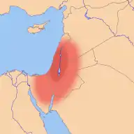
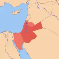
The Southern Levant is a geographical region encompassing the southern half of the Levant. It corresponds approximately to modern-day Israel, Palestine, and Jordan; some definitions also include southern Lebanon, southern Syria and/or the Sinai Peninsula. As a strictly geographical description, it is sometimes used by archaeologists and historians to avoid the religious and political connotations of other names for the area.

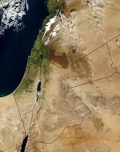
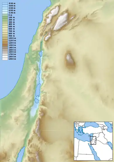
Like much of Southwestern Asia, the Southern Levant is an arid region consisting mostly of desert and dry steppe, with a thin strip of wetter, temperate climate along the Mediterranean coast. Geographically it is dominated by the Jordan Valley, a section of the Great Rift Valley bisecting the region from north to south, and containing the Sea of Galilee, the Jordan River and the Dead Sea – the lowest point on the earth's land surface.
The Southern Levant has a long history and is one of the areas of the world most intensively investigated by archaeologists. It is considered likely to be the first place that both early hominins and modern humans colonised outside of Africa. Consequently, it has a rich Stone Age archaeology, stretching back as early as 1.5 million years ago. With one of the earliest sites for urban settlements, it also corresponds to the western parts of the Fertile Crescent.
Terminology
The Southern Levant refers to the lower half of the Levant but there is some variance of geographical definition, with the widest definition including Israel, Palestine, Jordan, Lebanon, southern Syria and the Sinai Desert.[7] In the field of archaeology, the southern Levant is "the region formerly identified as Syria-Palestine and including Canaan."[9]
Many scholars studying the region's archaeology have adopted the term Levant (including northern and southern halves) as the "term of choice" due to it being a "wider, yet relevant, cultural corpus" that does not have the "political overtones" of Syria-Palestine.[9] A survey of North American dissertations shows the "overwhelming emphasis and scope of these works has been the southern Levant, an area formerly identified as Syria-Palestine including Canaan", but with most modern Ph.D. dissertations using the terms 'Israel' and 'Canaan'.[9]
The term "Southern Levant" has also been criticized as imprecise[10] and an awkward name.[11][12] The term Southern Levant has been described in academic discourse as a "at least a strictly geographical" description of the region, avoiding religious and political connotations of names such as "Canaan", "Holy Land", "Land of Israel", or "Palestine".[11]
Geography

The Southern Levant lies on the eastern coast of the Mediterranean Sea, in the world region known variously as the Near East, the Middle East or Western or Southwestern Asia. It is bordered to the east, southeast and southwest by the Syrian, Arabian and Sinai deserts, respectively.[3][5] Some definitions include parts of these deserts in the region.[1] The Litani River in southern Lebanon is commonly considered the dividing line between the Southern Levant and the Northern Levant (i.e. Syria),[1][2][5] or sometimes the Orontes River, also in Lebanon.[3]
For the most part, the climate of the Southern Levant is arid or semi-arid, however a narrow strip along the coast experiences a temperate, Mediterranean climate due to its proximity to the sea.[13] Average annual rainfall decreases sharply away from the coast, from over 1,000 millimetres (39 inches) per year in Galilee, to 200–400 millimetres (7.9–15.7 inches) in the Rift Valley, and less than 50 millimetres (2.0 inches) in the eastern deserts and the Negev.[14] Across the region, precipitation is both highly seasonal―most rain falls between October and May, and hardly any in the summer—and subject to large, unpredictable inter-annual variation.[13] Temperature is also highly variable, with cool winters and hot summers.
The Jordan River bisects much of the region into the Cisjordan and Transjordan. The Huleh basin feeds into the upper Jordan, which moves southward through a natural basalt barrier into the Sea of Galilee before dropping several hundred metres as it flows through the Jordan Valley. The Jordan River terminates at the Dead Sea, whose banks, at 400 metres (1,300 feet) below sea level, are the world's lowest point on dry land.[15]
Archaeological findings
The archaeology of the southern Levant is generally conceived as a series of phases or stages in human cultural and evolutionary development based, for the most part, on tool technology for early pre-historic, proto-historic and early historic periods. Later phases are generally associated with historical periods and are named accordingly.[16] While there is no single, accepted sequence that all archaeologists agree upon, the basic conventions indicate a number of Stone Ages, followed by a Copper/Stone Age, in turn followed by a Bronze Age. The names given to them, derived from the Greek, are also used widely for other regions. The different ages in turn are often divided up into sequential or sometimes parallel chrono-cultural facies, sometimes called “cultures” or “periods”. Sometimes their names are derived from European prehistory, at other times from local sites, often where they were first discovered.
Archaeologically, it is among the most extensively excavated regions in the world.[17]
Pre-history and Stone Age
The Southern Levant is amongst the oldest inhabited parts of Eurasia, being on one of three plausible routes by which early hominins could have dispersed out of Africa (along with the Bab al Mandab and the Strait of Gibraltar).[18] Homo erectus left Africa and became the first hominin species to colonise Europe and Asia approximately two million years ago, probably via the Southern Levant.[19][20] During this phase of the Pleistocene epoch the region was wetter and greener, allowing H. erectus to find places with fresh water as it followed other African animals that were dispersing out of Africa at the same time.[21] One such location was 'Ubeidiya, on the southern shore of the Sea of Galilee, where some of the oldest hominin remains in Eurasia have been discovered, dating to between 1.2 million and 1.5 million years ago.[22][23]
Several Stone Ages, when stone tools prevailed and make up the bulk of artifacts, are followed by periods when other technologies came into use. They lent their names to the different periods. The basic framework for the southern Levant is, as follows: Paleolithic or Old Stone Age is often divided up into phases called, from early-to-late: Lower Paleolithic, Middle Paleolithic and Upper Paleolithic. An Epipaleolithic (latest Paleolithic) period, also known as Mesolithic (transition to Neolithic) follows and is, in turn succeeded by a Neolithic (New Stone Age).
The following Chalcolithic period includes the first evidence of metallurgy with copper making its appearance. However, as stone technology remains prevalent, the name, Chalcolithic (Copper/Stone) age combines the two.
Bronze Age
Bronze is used for the following periods, but is actually a misnomer for a good part of that time. An Early Bronze Age is divided into three major phases, Early Bronze I, II and III, but copper and not bronze was the most common metal in use, while stone technology continued to contribute the bulk of tools. Early Bronze III is followed by another period, alternately named Early Bronze IV, Middle Bronze I, Intermediate Bronze or Early Bronze-Middle Bronze. In this period the name is apt; true bronze (a tin alloy of copper) makes its appearance in this time span.
The next period is generally known as Middle Bronze II and is generally broken down into two sub-periods, Middle Bronze IIa and Middle Bronze IIb. Some scholars acknowledge a Middle Bronze III. The next period is known as Late Bronze and is often sub-divided into Late Bronze I and II.
Iron Age
The introduction of iron, although relatively rare, especially in the earliest phases, caused the following phase to be named the Iron Age. It is variously sub-divided into Iron I, Iron II and sometimes Iron III, with subdivisions becoming increasingly popular as sequences become better known. Some archaeologists suggest that there in the transition from the Late Bronze Age to the Early Iron Age, the large cultural differences are explained by foreign invasion, that is, the introduction of new ethnicity. More recent evidence indicates that the large culture changes were not the result of a foreign invasion. Rather, the Iron Age people of the southern Levant were related to their Bronze Age predecessors.[24]
Later historical periods
The post-Iron Age is generally thought of as historical and accordingly names of periods reflect this. The very latest Iron Age phase is sometimes called "Assyrian" and the following period is universally known as the Persian period.
The 333 BCE conquest of the region by Alexander the Great is accepted as the beginning of the Hellenistic period. The Deuterocanonical book 2 Maccabees records: "Apollonius the son of Tharseas, who at that time was governor of Celesyria and Phenicia", Celesyria being the transliteration of Coele-Syria.[25] It is followed by the Roman period, with an Early and Late Roman sub-period. The 4th century is recognised as the beginning of the Byzantine period, that lasted until the Arab conquest of the region.
The following period is known as Early Arab and sub-periods by the names of reigning dynasties. The Crusader conquest of the region is known, appropriately as the Crusader period, which in part overlaps with Ayyubid rule, and it is followed by a Mamluk period after the conquering power. In 1516–17 the Ottoman Empire conquered the region and gave its name to the period that lasted until 1917–18, when the British conquered it in World War I.
See also
References
- Yakar, Jak (1998). "The socio-economic structure of prehistoric communities in the Southern Levant, c. 13000-8000 BP". Documenta Praehistorica. XXV.
The Levant, which extends from the southern flanks of the eastern Taurus in the north, down to the Sinai peninsula in the south, defines a territory c. 1,300 kilometres (810 miles) long and 350 kilometres (220 miles) wide. The Northern Levant includes the region encompassing the north-eastern Mediterranean littoral and the valleys of the Orontes, Middie Euphrates and Balikh in Syria. The region defined as the Southern Levant encompasses the territory crossed by the valleys of the Litani and Jordan, including the Mediterranean littoral extending from Lebanon to northern Sinai. Moreover, the Negev, the Sinai peninsula and Jordan are considered parts of this vast region.
- Peregrine, Peter N.; Ember, Melvin (2003). Encyclopedia of Prehistory: Volume 8: South and Southwest Asia. Springer Science & Business Media. p. 86. ISBN 9780306462627.
The southern Levant, as defined here, is delimited by the Litani River to the north, the Jordan Rift Valley to the East, the Gulf of Aqaba to the south, and the Mediterranean Sea and Sinai Desert to the west.
- Routledge, Bruce (2004). Moab in the Iron Age: Hegemony, Polity, Archaeology. University of Pennsylvania Press. p. 223. ISBN 978-0812238013.
The southern Levant refers to all of the territory south of the headwaters of the Orontes River and west of the Syrian Desert.
- Stone, Peter James (2012). 'Provincial' Perspectives: The Persian, Ptolemaic, and Seleucid Administrative Center at Tel Kedesh, Israel, in a Regional Context (PDF) (Thesis).
- Steiner, Margreet L.; Killebrew, Ann E. (2014). The Oxford Handbook of the Archaeology of the Levant: C. 8000–332 BCE. OUP Oxford. p. 35. ISBN 9780199212972.
The term Levant, as used here, covers an area that is often referred to in archaeological works by other terms most notably Syria-Palestine and North Syria. [...] The western coastline and the eastern deserts set the boundaries for the Levant and these natural barriers will therefore serve as brackets for the area under discussion. The general limits of the Levant as defined here begin at the Plain of 'Amuq in the north and extend south until the Wadi al-Arish along the northern coast of Sinai. The western coastline and the eastern deserts set the boundaries for the Levant [...] The Euphrates and the area around Jebel el-Bishrī mark the eastern boundary of the northern Levant, as does the Syrian Desert beyond the Anti-Lebanon range's eastern hinterland and Mount Hermon. This boundary continues south in the form of the highlands and eastern desert regions of Transjordan. Although the geographical boundaries described here are not absolute the Litani River will mark the division of the northern Levant from the southern Levant. Cyprus is not part of the Levant geographically but it is included on account of its proximity (and resulting cultural ties), as well as its geographical significance, size and natural resources.
- Rowan, Yorke M.; Golden, Jonathan (2009). "The Chalcolithic Period of the Southern Levant: A Synthetic Review". Journal of World Prehistory. 22 (1): 1–92. doi:10.1007/s10963-009-9016-4. ISSN 0892-7537. S2CID 161591161.
The focus of this discussion, the southern Levant, encompasses the southern sections of Lebanon and Syria, the Palestine Autonomous Authority, Israel, and Jordan.
- Levy, Thomas E.; Najjar, Mohammad; Higham, Thomas (2010). "Ancient texts and archaeology revisited – radiocarbon and Biblical dating in the southern Levant". Antiquity. 84 (325): 834–847. doi:10.1017/S0003598X00100250. ISSN 1745-1744. S2CID 162929945.
One of the world's 'hot spots' for this kind of historically-led archaeology is still the southern Levant – the region that includes Israel, the Palestinian territories, Jordan, Lebanon, southern Syria and the Sinai Desert.
- "CISA3 Archaeologists Develop 3-D Images of Artifacts for Digital Pottery Informatics Database". ucsdnews.ucsd.edu. Retrieved 2016-07-26.
In its initial format, the DPID will consist of data from the Iron Age (c. 1,200–500 BCE) ceramic database of the southern Levant, a region of the Middle East that now incorporates areas of Jordan, Israel, Palestine, Southern Lebanon, Syria and the Sinai Peninsula.
- Burke, Aaron A. (2016). "The Transformation of Biblical and Syro-Palestinian Archaeology". In Levy, Thomas Evan (ed.). Historical Biblical Archaeology and the Future: The New Pragmatism. Routledge. ISBN 9781134937530.
Much work continues to be done in these regions, and not surprisingly this work is now of great interest to those studying the southern Levant (i.e. the region formerly identified as Syria-Palestine and including Canaan) [...] Nevertheless, despite such a well-reasoned basis for the identification of Levantine archaeology, the adoption of this term by many scholars has been, for the most part, simply the result of individual attempts to consider a wider, yet relevant, cultural corpus than that which is suggested by the use of terms like Canaan, Israel, or even Syria-Palestine. Regardless of the manner in which the term has come into common use, for a couple of additional reasons it seems clear that the Levant will remain the term of choice. In the first place scholars have shown a penchant for the term Levant, despite the fact that the term 'Syria-Palestine' has been advocated since the late 1970s. This is evident from the fact that no journal or series today has adopted a title that includes 'Syria-Palestine'. However, the journal Levant has been published since 1969 and since 1990 Ägypten und Levante has also attracted a plethora of papers relating to the archaeology of this region. Furthermore, a search through any electronic database of titles reveals an overwhelming adoption of the term 'Levant' when compared to 'Syria-Palestine' for archaeological studies. Undoubtedly, this is mostly due to the fact that 'Syria-Palestine' is, correctly speaking, the title for a Roman administrative division of the Levant created by Hadrian (Millar 1993). The term 'Syria-Palestine' also carries political overtones that inadvertently evoke current efforts to establish a full-fledged Palestinian state. Scholars have recognised, therefore, that—for at least the time being—they can spare themselves further headaches by adopting the term Levant to identify this region.
- "Note éditoriale" [Editorial remarks]. Paléorient. 19 (1). 1993.
In gathering contributions for the present issue, it soon became apparent – and this is a generally valid point – that imprecise terminology is one of the major difficulties encountered in our research. An example is the term "Southern Levant" used as a substitute for the geographers' "Palestine". The use of this term hides the particularism of the regions on either side of the Jordan Valley just when the discoveries of the last decade have highlighted their specificity. The lack of precision traditional terminology (agriculture, herding, pastoralism, Neolithic, etc.) applied to the complex phenomena that we are studying constantly leads to misunderstandings.
- de Geus, C. H. J. (2003). Towns in Ancient Israel and in the Southern Levant. Palaestina Antiqua 10. Peeters Publishers. p. 6. ISBN 9789042912694.
At the beginning of this Introduction I have indicated how difficult it is to choose a general accepted name for the region this book deals with. In Europe we are used to the late Roman name 'Palestine,' and the designation 'Palestinian Archaeology' has a long history. According to Byzantine usage it included CisJordan and TransJordan and even Lebanon and Sinai. In modern times, however, the name 'Palestine' has exclusively become the political designation for a restricted area. Furthermore, in the period this book deals with a region called 'Palestine' did not yet exist. Also the ancient name 'Canaan' cannot be used as it refers to an older period in history. Designations as: 'The Land(s) of the Bible' or 'the Hold Land' evoke the suspicion of a theological bias. 'The Land of Israel' does not apply to the situation because it never included Lebanon or the greater part of modern Jordan. Therefore I have joined those who today advocate the designation 'Southern Levant.' Although I confess that it is an awkward name, it is at least strictly geographical.
- Arnold, Bill T. (2014). Introduction to the Old Testament. Cambridge: Cambridge University Press. p. 37. ISBN 9780521879651.
What we call the land of the Bible today has potential for misunderstanding. This small strip of land in the Southern Levant has been occupied by so many, fought over and carved up so many times, that it is hard to know just what to call it. The use of 'Israel' implies to some that all of it belongs today only to the Jews as legitimate descendants of OT Israel. Similarly, 'Palestine' has a longstanding usage, but may imply that all of it belongs to Palestinian Arabs exclusively. Both of these terms could be used strictly for geography. But because of the contemporary Israeli-Palestinian conflict, both terms also may introduce misunderstanding. And biblical scholars have no universal agreement on this topic. 'Syria-Palestine' is often used, as here, for geographical precision. But it is only the southern portion of Syria-Palestine that was occupied by ancient Israel, and it does not always communicate sufficiently. 'Canaan' is an ancient name, but it also is not exactly conterminous with the land occupied by ancient Israel. I have used 'Southern Levant' occasionally here but admit that this is a strange expression. l will most often refer simply to 'Israel,' by which I mean the territory of national Israel in the OT, but hope the reader will understand no modern political claims by this use.
- Ziv, Baruch; Dayan, Uri; Kushnir, Yohanan; Roth, Chaggi; Enzel, Yehouda (2006-01-01). "Regional and global atmospheric patterns governing rainfall in the southern Levant". International Journal of Climatology. 26 (1): 55–73. Bibcode:2006IJCli..26...55Z. doi:10.1002/joc.1238. ISSN 1097-0088.
- Ziv, Baruch; Saaroni, Hadas; Pargament, Roee; Harpaz, Tzvi; Alpert, Pinhas (2013-02-22). "Trends in rainfall regime over Israel, 1975–2010, and their relationship to large-scale variability". Regional Environmental Change. 14 (5): 1751–1764. doi:10.1007/s10113-013-0414-x. ISSN 1436-3798. S2CID 154422674.
- Orni, Efraim; Efrat, Elisha (1971). Geography of Israel (3rd ed.). American Heritage Press. ISBN 978-0070477018.
- Crassard, Rémy; Petraglia, Michael D.; Parker, Adrian G.; Parton, Ash; Roberts, Richard G.; Jacobs, Zenobia; Alsharekh, Abdullah; Al-Omari, Abdulaziz; Breeze, Paul; Drake, Nick A.; Groucutt, Huw S. (2013-07-19). "Beyond the Levant: First Evidence of a Pre-Pottery Neolithic Incursion into the Nefud Desert, Saudi Arabia". PLOS ONE. 8 (7): e68061. Bibcode:2013PLoSO...868061C. doi:10.1371/journal.pone.0068061. ISSN 1932-6203. PMC 3716651. PMID 23894294.
- Anfinset, Nils (2003). "A passion for cultural difference. Archaeology and ethnicity in the southern Levant". Norwegian Archaeological Review. 36 (1): 45–63. doi:10.1080/00293650307299. S2CID 143828715. Retrieved 2016-04-26.
- Fleagle, John G., Shea, John J., Grine, Frederick E., Baden, Andrea L., Leakey, Richard E., "Out of Africa I: The First Hominin Colonization of Eurasia", Springer 2010 pp 247–273.
- Abbate, Ernesto; Sagri, Mario (2012-07-26). "Early to Middle Pleistocene Homo dispersals from Africa to Eurasia: Geological, climatic and environmental constraints". Quaternary International. The genus Homo from Africa to Europe: evolution of terrestrial ecosystems and dispersal routes. 267: 3–19. Bibcode:2012QuInt.267....3A. doi:10.1016/j.quaint.2011.02.043.
- Rolland, Nicolas (2013-12-06). "The Early Pleistocene human dispersals in the Circum-Mediterranean Basin and initial peopling of Europe: Single or multiple pathways?". Quaternary International. Middle to Upper Palaeolithic biological and cultural shift in Eurasia II. 316: 59–72. Bibcode:2013QuInt.316...59R. doi:10.1016/j.quaint.2013.06.028.
- Carotenuto, F.; Tsikaridze, N.; Rook, L.; Lordkipanidze, D.; Longo, Laura; Condemi, Silvana; Raia, P. (2016-06-01). "Venturing out safely: The biogeography of Homo erectus dispersal out of Africa". Journal of Human Evolution. 95: 1–12. doi:10.1016/j.jhevol.2016.02.005. hdl:10220/41176. PMID 27260171.
- Chazan, Michael (2015-10-05). World Prehistory and Archaeology. Routledge. p. 82. ISBN 9781317347514.
- Martínez-Navarro, Bienvenido; Belmaker, Miriam; Bar-Yosef, Ofer (2009-05-01). "The large carnivores from 'Ubeidiya (early Pleistocene, Israel): biochronological and biogeographical implications". Journal of Human Evolution. 56 (5): 514–524. doi:10.1016/j.jhevol.2009.02.004. PMID 19427671.
- Ullinger, Jaime M.; Sheridan, Susan Guise; Hawkey, Diane E.; Turner, Christy G.; Cooley, Robert (2005-10-01). "Bioarchaeological analysis of cultural transition in the southern Levant using dental nonmetric traits". American Journal of Physical Anthropology. 128 (2): 466–476. doi:10.1002/ajpa.20074. ISSN 0002-9483. PMID 15895418.
- 2 Maccabees 3:8

