South Dakota Highway 130
South Dakota Highway 130 (SD 130) is a 7.111-mile (11.444 km)[1] state highway in Walworth County, South Dakota, United States, that connects the city of Selby with the town of Java.
Highway 130 | ||||
|---|---|---|---|---|
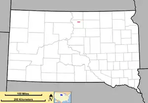 Route of SD 130 (in red) | ||||
| Route information | ||||
| Maintained by SDDOT | ||||
| Length | 7.111 mi[1] (11.444 km) | |||
| Existed | 1976–present | |||
| Major junctions | ||||
| West end | ||||
| East end | ||||
| Location | ||||
| Country | United States | |||
| State | South Dakota | |||
| Counties | Walworth | |||
| Highway system | ||||
| ||||
| ||||

Route description
SD 130 begins at an intersection with the concurrent highways U.S. Route 12 (US 12), US 83, and SD 20 in Selby. It travels in a due eastward direction, with the exception of a northward curve around some railroad tracks through open fields for its entire length, and comes to an end at SD 271 in Java. It utilizes a portion of 130th Street for its path.[2]
History
SD 130 was designated in 1976 as a redesignation of SD 103.
Major intersections
The entire route is in Walworth County. [2]
| Location[2] | mi[1] | km | Destinations | Notes | |
|---|---|---|---|---|---|
| Selby | 0.000 | 0.000 | Western terminus | ||
| Java | 7.111 | 11.444 | Eastern terminus | ||
| 1.000 mi = 1.609 km; 1.000 km = 0.621 mi | |||||
References
- "Pierre Region Highway Log" (PDF). dot.sd.gov (January 2019 ed.). South Dakota Department of Transportation. 27 Feb 2019. p. 91. Retrieved 4 Nov 2019.
- Google (4 Nov 2019). "SD 130, South Dakota" (Map). Google Maps. Google. Retrieved 4 Nov 2019.
External links
Wikimedia Commons has media related to South Dakota Highway 130.
Template:Attached KML/South Dakota Highway 130
KML is from Wikidata
This article is issued from Wikipedia. The text is licensed under Creative Commons - Attribution - Sharealike. Additional terms may apply for the media files.