South Carolina Highway 202
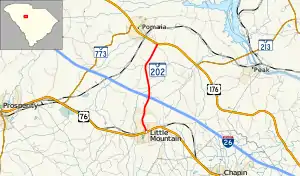
South Carolina Highway 202 (SC 202) is a 4.520-mile-long (7.274 km) state highway in the U.S. state of South Carolina. The highway connects Little Mountain and the Pomaria area. Though signed as an east-west highway, it runs in a south-to-north fashion.
South Carolina Highway 202 | ||||
|---|---|---|---|---|
 | ||||
| Route information | ||||
| Maintained by SCDOT | ||||
| Length | 4.520 mi[1] (7.274 km) | |||
| Major junctions | ||||
| West end | ||||
| East end | ||||
| Location | ||||
| Country | United States | |||
| State | South Carolina | |||
| Counties | Newberry | |||
| Highway system | ||||
| ||||
Route description
SC 202 begins at an intersection with U.S. Route 76 (US 76; Main Street) in Little Mountain, within Newberry, where the roadway continues as a local road in downtown Little Mountain. It travels to the north-northwest and leaves the city limits. The highway immediately curves to the north-northeast and has an interchange with Interstate 26 (I-26). It curves to the north and crosses over Rocky Creek. After one final north-northwest segment, the highway curves to the northeast and meets its western terminus, an intersection with US 176, at a point southeast of Pomaria.[2]
Major intersections
The entire route is in Newberry County.
| Location | mi[1] | km | Destinations | Notes | |
|---|---|---|---|---|---|
| Little Mountain | 0.000 | 0.000 | Western terminus | ||
| | 1.769– 1.780 | 2.847– 2.865 | I-26 exit 85 | ||
| | 4.520 | 7.274 | Eastern terminus | ||
| 1.000 mi = 1.609 km; 1.000 km = 0.621 mi | |||||
See also
References
- "Highway Logmile Report". South Carolina Department of Transportation. Retrieved December 26, 2020.
- Google (May 10, 2016). "South Carolina Highway 202" (Map). Google Maps. Google. Retrieved May 10, 2016.
External links
 Media related to South Carolina Highway 202 at Wikimedia Commons
- SC 202 at Virginia Highways' South Carolina Highways Annex
