South Carolina Highway 172
South Carolina Highway 172 (SC 172) is a nine-point-zero-zero-zero-mile-long (14.484 km) state highway in the U.S. state of South Carolina. The highway travels through rural areas of Orangeburg and Calhoun counties.
South Carolina Highway 172 | ||||
|---|---|---|---|---|
 | ||||
| Route information | ||||
| Maintained by SCDOT | ||||
| Length | 9.000 mi[1][2] (14.484 km) | |||
| Major junctions | ||||
| West end | ||||
| East end | ||||
| Location | ||||
| Country | United States | |||
| State | South Carolina | |||
| Counties | Orangeburg, Calhoun | |||
| Highway system | ||||
| ||||

Route description
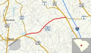
SC 172 begins at an intersection with U.S. Route 178 (US 178; North Road) east-northeast of North, within Orangeburg County. It travels to the north-northeast. Approximately 1,000 feet (300 m) later, it meets the eastern terminus of SC 692, with SC 172 heading to the east-northeast before it enters Calhoun County. It passes by the Do-Little Field airport just before it meets US 21 (Columbia Road). SC 172 continues another 0.09 miles (0.14 km) to end at SC 6 (Caw Caw Road).[3]
Major intersections
| County | Location | mi[1]</ref>[2] | km | Destinations | Notes |
|---|---|---|---|---|---|
| Orangeburg | | 0.000 | 0.000 | Western terminus | |
| | 0.230 | 0.370 | Eastern terminus of SC 692 | ||
| Calhoun | | 8.910 | 14.339 | ||
| | 9.000 | 14.484 | Eastern terminus | ||
| 1.000 mi = 1.609 km; 1.000 km = 0.621 mi | |||||
See also
References
- "Highway Logmile Report". South Carolina Department of Transportation. Retrieved December 25, 2020.
- "Highway Logmile Report". South Carolina Department of Transportation. Retrieved December 25, 2020.
- Google (May 20, 2018). "South Carolina Highway 172" (Map). Google Maps. Google. Retrieved May 20, 2018.
External links
Template:Attached KML/South Carolina Highway 172
KML is not from Wikidata
 Media related to South Carolina Highway 172 at Wikimedia Commons
- SC 172 at Virginia Highways' South Carolina Highways Annex
This article is issued from Wikipedia. The text is licensed under Creative Commons - Attribution - Sharealike. Additional terms may apply for the media files.