Seismic zone
In seismology, a seismic zone or seismic belt is an area of seismicity potentially sharing a common cause. It may also be a region on a map for which a common areal rate of seismicity is assumed for the purpose of calculating probabilistic ground motions. An obsolete definition is a region on a map in which a common level of seismic design is required.[1]
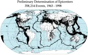
Earthquake epicenters 1963–98
A type of seismic zone is a Wadati–Benioff zone which corresponds with the down-going slab in a subduction zone.[2]
Examples
See also
References
![]() This article incorporates public domain material from websites or documents of the United States Geological Survey.
This article incorporates public domain material from websites or documents of the United States Geological Survey.
- "What is a seismic zone, or seismic hazard zone? Where can I find information on seismic zones 0, 1, 2, 3, or 4? What seismic zone is location X in?". United States Geological Survey. Retrieved 2018-05-31.
- "Benioff zone (seismic belt) – Britannica Online Encyclopedia". Britannica.com. Retrieved 2018-05-31.
This article is issued from Wikipedia. The text is licensed under Creative Commons - Attribution - Sharealike. Additional terms may apply for the media files.