Saint-Léon-le-Grand, Bas-Saint-Laurent, Quebec
Saint-Léon-le-Grand is a parish municipality in Quebec, Canada.
Saint-Léon-le-Grand | |
|---|---|
 | |
_Quebec_location_diagram.png.webp) Location within La Matapédia RCM. | |
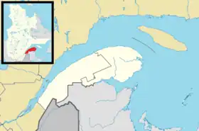 Saint-Léon-le-Grand Location in eastern Quebec. | |
| Coordinates: 48°23′N 67°30′W[1] | |
| Country | |
| Province | |
| Region | Bas-Saint-Laurent |
| RCM | La Matapédia |
| Settled | 1896 |
| Constituted | August 12, 1903 |
| Named for | Pope Leo I[1] |
| Government | |
| • Mayor | Steve Lamontagne |
| • Federal riding | Haute-Gaspésie—La Mitis—Matane—Matapédia |
| • Prov. riding | Matane-Matapédia |
| Area | |
| • Total | 128.50 km2 (49.61 sq mi) |
| • Land | 128.26 km2 (49.52 sq mi) |
| Population | |
| • Total | 968 |
| • Density | 7.5/km2 (19/sq mi) |
| • Pop 2016-2021 | |
| • Dwellings | 447 |
| Time zone | UTC−5 (EST) |
| • Summer (DST) | UTC−4 (EDT) |
| Postal code(s) | |
| Area code(s) | 418 and 581 |
| Highways | |
| Website | www.saintleon legrand.com |
Geography
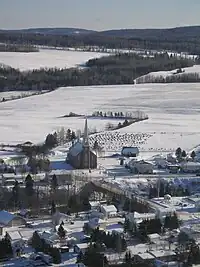
Saint-Léon-le-Grand is located on the southern slope of the St. Lawrence River, 430 km northeast of Quebec City and 110 km southeast of Rimouski. Important towns near Saint-Léon-le-Grand are Amqui at 12 km and Lac-au-Saumon at 16 km to the east. Causapscal at 27 km to the east as well as Sayabec at 33 km to the north. Saint-Léon-le-Grand is located on Route 195 halfway between Amqui and Saint-Zénon-du-Lac-Humqui. The territory of Saint-Léon-le-Grand covers an area of 127 km2. Most of this territory is mountainous and covered with forests.
The municipality of Saint-Léon-le-Grand is located in the regional county municipality (RCM) of La Matapédia in the administrative region of Bas-Saint-Laurent. The eponymous parish of Saint-Léon-le-Grand is located in the Roman Catholic Archdiocese of Rimouski and, more specifically, in the pastoral region of La Matapédia. Saint-Léon-le-Grand is part of the Gaspésie tourist region in the Matapédia Valley tourist sub-region.
Demographics
| Year | Pop. | ±% |
|---|---|---|
| 1911 | 2,310 | — |
| 1921 | 1,902 | −17.7% |
| 1931 | 1,494 | −21.5% |
| 1941 | 1,177 | −21.2% |
| 1951 | 2,068 | +75.7% |
| 1956 | 2,119 | +2.5% |
| 1961 | 2,139 | +0.9% |
| 1966 | 1,933 | −9.6% |
| 1971 | 1,570 | −18.8% |
| 1976 | 1,325 | −15.6% |
| 1981 | 1,335 | +0.8% |
| 1986 | 1,277 | −4.3% |
| 1991 | 1,150 | −9.9% |
| 1996 | 1,145 | −0.4% |
| 2001 | 1,144 | −0.1% |
| 2006 | 1,073 | −6.2% |
| 2011 | 970 | −9.6% |
| 2016 | 953 | −1.8% |
| 2021 | 968 | +1.6% |
In the 2021 Census of Population conducted by Statistics Canada, Saint-Léon-le-Grand had a population of 968 living in 420 of its 447 total private dwellings, a change of 1.6% from its 2016 population of 953. With a land area of 128.26 km2 (49.52 sq mi), it had a population density of 7.5/km2 (19.5/sq mi) in 2021.[5]
| 2021 | 2016 | 2011 | |
|---|---|---|---|
| Population | 968 (+1.6% from 2016) | 953 (-1.8% from 2011) | 970 (-9.6% from 2006) |
| Land area | 128.26 km2 (49.52 sq mi) | 128.47 km2 (49.60 sq mi) | 128.50 km2 (49.61 sq mi) |
| Population density | 7.5/km2 (19/sq mi) | 7.4/km2 (19/sq mi) | 7.5/km2 (19/sq mi) |
| Median age | 51.6 (M: 54.4, F: 48.8) | 51.3 (M: 51.8, F: 50.6) | 47.7 (M: 49.4, F: 46.3) |
| Private dwellings | 420 (total) | 440 (total) | 434 (total) |
| Median household income | $48,256 | $43,349 |
References
- "Reference number 57073 in Banque de noms de lieux du Québec". toponymie.gouv.qc.ca (in French). Commission de toponymie du Québec.
- "Saint-Léon-le-Grand". Répertoire des municipalités (in French). Ministère des Affaires municipales, des Régions et de l'Occupation du territoire. Retrieved 2012-01-30.
- "2021 Community Profiles". 2021 Canadian Census. Statistics Canada. February 4, 2022. Retrieved 2022-04-27.
- Statistics Canada: 1996, 2001, 2006, 2011, 2016, 2021 census
- "Population and dwelling counts: Canada, provinces and territories, and census subdivisions (municipalities), Quebec". Statistics Canada. February 9, 2022. Retrieved August 29, 2022.
- "2016 Community Profiles". 2016 Canadian Census. Statistics Canada. August 12, 2021. Retrieved 2022-11-01.
- "2011 Community Profiles". 2011 Canadian Census. Statistics Canada. March 21, 2019. Retrieved 2014-02-06.
- "2006 Community Profiles". 2006 Canadian Census. Statistics Canada. August 20, 2019.
- "2001 Community Profiles". 2001 Canadian Census. Statistics Canada. July 18, 2021.
Adjacent Municipal Subdivisions | ||||||||||||||||
|---|---|---|---|---|---|---|---|---|---|---|---|---|---|---|---|---|
| ||||||||||||||||
| Cities & Towns | |
|---|---|
| Municipalities | |
| Parishes | |
| Villages | |
| Unorganized territories | |
| |