Utah State Route 63
Utah State Route 63 (SR-63) is a state highway in the U.S. state of Utah. Just 2.63 miles (4.23 km) long, it serves as a connection between Utah State Route 12 (a scenic byway) and Bryce Canyon National Park.
State Route 63 | ||||
|---|---|---|---|---|
SR 63 highlighted in red | ||||
| Route information | ||||
| Maintained by UDOT | ||||
| Length | 2.630 mi[1] (4.233 km) | |||
| Existed | 1975[2]–present | |||
| Major junctions | ||||
| South end | North boundary of Bryce Canyon National Park | |||
| North end | ||||
| Location | ||||
| Country | United States | |||
| State | Utah | |||
| Highway system | ||||
| ||||
| ||||

Route description
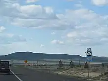
Starting from the northern edge of Bryce Canyon National Park, the route runs northward, passing a view area, and exiting Dixie National Forest within the first mile. It continues north until its terminus at the intersection with SR-12 less than two miles later.
History
Previous designation
This route number was originally in use from 1931 – 1971 as a route from Salina to Scipio. The route number was withdrawn when this route was transferred to SR-26, and subsequently designated as part of US-50.
Current designation
Utah State Route 12 originally had a short spur serving Bryce Canyon. This spur was split off into a distinct highway, SR-63, in 1975.[2]
Major intersections
The entire route is in Garfield County.
| Location | mi[1] | km | Destinations | Notes | |
|---|---|---|---|---|---|
| | 0.000 | 0.000 | North boundary of Bryce Canyon National Park | Southern terminus | |
| 0.494 | 0.795 | View area | |||
| Tropic Junction | 2.630 | 4.233 | Northern terminus | ||
| 1.000 mi = 1.609 km; 1.000 km = 0.621 mi | |||||
References
- "State Route 63 Highway reference". Utah Department of Transportation. Retrieved 2009-07-08.
- "State Route 63 Resolutions". Utah Department of Transportation. November 2008. Retrieved 2009-07-08.