Colorado State Highway 93
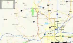
State Highway 93 (SH 93) is a state highway in Colorado that connects Golden and Boulder. SH 93's southern terminus is at U.S. Route 6 (US 6) and SH 58 in Golden, and the northern terminus is at SH 119 in Boulder.
State Highway 93 | ||||
|---|---|---|---|---|
 Map of north central Colorado with SH 93 highlighted in red | ||||
| Route information | ||||
| Maintained by CDOT | ||||
| Length | 18.849 mi[1] (30.335 km) | |||
| Major junctions | ||||
| South end | ||||
| North end | ||||
| Location | ||||
| Country | United States | |||
| State | Colorado | |||
| Counties | Jefferson, Boulder | |||
| Highway system | ||||
| ||||
| ||||
Route description

Intersection of SH 93, SH 58 and US 6 in Golden as seen from Mount Zion
SH 93 runs 18.8 miles (30.3 km), starting at its southern junction with US 6 and SH 58 at the entrance to Clear Creek Canyon in Golden. It runs north, just east of the mountains, ending at a junction with SH 119 in central Boulder.
Major intersections
| County | Location | mi | km | Destinations | Notes |
|---|---|---|---|---|---|
| Jefferson | Golden | 0.000 | 0.000 | Southern terminus, western terminus of SH 58 | |
| Arvada | 7.573 | 12.188 | |||
| Boulder | | 11.781 | 18.960 | Western terminus of SH 128 | |
| | 13.632 | 21.939 | |||
| Boulder | 17.422 | 28.038 | Baseline Road (SH 36E east) | ||
| 18.849 | 30.335 | Northern terminus | |||
| 1.000 mi = 1.609 km; 1.000 km = 0.621 mi | |||||
References
- "Segment list for SH 93". Retrieved 2011-01-19.
External links
Template:Attached KML/Colorado State Highway 93
KML is from Wikidata
![]() Media related to Colorado State Highway 93 at Wikimedia Commons
Media related to Colorado State Highway 93 at Wikimedia Commons
This article is issued from Wikipedia. The text is licensed under Creative Commons - Attribution - Sharealike. Additional terms may apply for the media files.
