Río Matilde
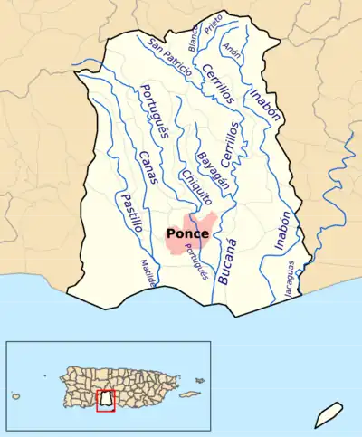
Río Matilde is a short river in the municipality of Ponce, Puerto Rico. It forms from the confluence of Rio Pastillo and Rio Canas.[1] Río Matilde is one of the 14 rivers in the municipality and, forming at an altitude of just 15 feet (4.6 m), it forms at an altitude lower than any other river in the municipality.
| Río Matilde | |
|---|---|
.jpg.webp) | |
| Location | |
| Commonwealth | Puerto Rico |
| Municipality | Ponce |
| Physical characteristics | |
| Source | |
| • location | Convergence of Rio Pastillo and Rio Canas, Barrio Canas, Ponce, Puerto Rico[1] |
| • coordinates | 18.1319046°N 66.5798949°W[2] |
| • elevation | 15 feet (4.6 m)[4] |
| Mouth | |
• location | Caribbean Sea |
• elevation | 0 feet (0 m) |
| Length | 1.7 km (1.1 mi)[4] |
| Basin features | |
| Progression | Canas Urbano Playa |
| Tributaries | |
| • left | Río Pastillo |
| • right | Rio Canas |

Origin
The name Río Matilde has sometimes been used to refer to a segment of Río Pastillo,[5][note 1] but Río Matilde actually results from the confluence of Río Pastillo and Río Canas.[6] Río Pastillo joins from its easterly run in the western section of the municipality of Ponce, while Río Canas joins from its southerly run in the northwestern area of the municipality of Ponce, both merging to form Río Matilde at their confluence in Barrio Canas just west of Urbanizacion Rio Canas and north of PR-2 in Ponce.
Features
At 1.7 kilometers (1.1 mi) long, Río Matilde is the shortest river in the municipality of Ponce. The river is approximately one mile long and empties into the Caribbean Sea at 17°58'55"N, 66°38'16"W in the area of Los Meros in Barrio Playa.[6][7]
Course
The following table summarizes the course of Rio Matilde in terms of roads crossed. Roads are listed as the river flows from its origin in the confluence of Rio Pastillo and Rio Canas, located in Barrio Canas, east of the city of Ponce, to its emptying into the Caribbean Sea in Barrio Playa in the south (N/A = Data not available):
| No. | Barrio | Road | Road's km marker | NBI ID[9] | Bridge name (if any) | Direction (of bridge traffic) | Coordinates | Notes |
|---|---|---|---|---|---|---|---|---|
| 1 | Canas Urbano | PR-2 | 225.5 | 8352 | Unnamed | Westbound | 18°59′44.8434″N 66°38′5.856″W | |
| 2 | Canas Urbano | PR-2 | 225.5 | 8752 | Unnamed | Eastbound | 18°59′44.34″N 66°38′5.856″W | |
| 3 | Playa | PR-52 | 107.8 | 24172 | Unnamed | Westbound | 17°59′31.128″N 66°38′12.444″W | |
| 4 | Playa | PR-52 | 107.8 | 24162 | Unnamed | Eastbound | 17°59′30.516″N 66°38′12.552″W | |
Notes
- Rio Matilde has sometimes been erroneously called Río Pastillo. In particular a segment of that river (Río Pastillo) that flows into Río Matilde has been called Río Matilde. For example HERE (Informe Ecologico de Flora y Fauna, Proyecto Gasoducto del Sur: Peñuelas, Ponce, Juana Díaz, Santa Isabel, Salinas. For: Proyecto Gasoducto del Sur - Peñuelas, Ponce, Juana Díaz, Santa Isabel, Salinas. By: ENSR (Piscatway, NJ) - AEE (Autoridad de Energia Electrica). Page 19. Retrieved 26 November 2013.) states "Río Matilde: ... Hacia el Norte desde su intersección con la Quebrada del Agua se le conoce como Río Pastillo." Translated and paraphased: North of its intersection with Quebrada del Agua creek, Rio Matilde is known as Río Pastillo.
References
- Sunny A. Cabrera Salcedo. Hacia un Estudio Integral de la Toponimia del Municipio de Ponce, Puerto Rico. Ph. D. dissertation. May 1999. University of Massachusetts Amherst. Graduate School. Department of Spanish and Portuguese. Page 14.
- U.S. Geological Survey Geographic Names Information System: Río Matilde
- U.S. Geological Survey Geographic Names Information System: Río Matilde
- Maptest. Archived 2010-02-18 at the Wayback Machine Government of the Commonwealth of Puerto Rico. General Purpose Population Data, Census 2000. Unidad de Sistemas de Información Geográfica, Área de Tecnología de Información Gubernamental, Oficina de Gerencia y Presupuesto. Gobierno de Puerto Rico. Retrieved 24 October 2011.
- Estudios Sociales: Hidrografia, Ponce, Puerto Rico. Projecto Salon Hogar. Retrieved August 8, 2009.
- Rio Matilde. U.S. Geological Survey. Department of the Interior. Retrieved 9 October 2011.
- Recursos Naturales. Archived 2011-06-11 at the Wayback Machine Government of the Autonomous Municipality of Ponce. Retrieved 9 October 2011.
- Ponce en Marcha: Obras que si se ven. Government of Puerto Rico. El Sur a la Vista. Ponce, Puerto Rico. 2 November 2011. Page 56.
- National Bridge Inventory Data: Puerto Rico, Ponce. James Baughn. BridgeReports.com 2018. Accessed 26 November 2018.