Rainworth, Queensland
Rainworth is a neighbourhood in the suburb of Bardon, City of Brisbane, Queensland, Australia.[3]
| Rainworth Brisbane, Queensland | |
|---|---|
 Entrance to Rainworth State School, 2018 | |
 Rainworth | |
| Coordinates | 27.4667°S 152.9833°E |
| Postcode(s) | 4065 |
| Location | 5.0 km (3 mi) W of Brisbane GPO |
| LGA(s) | City of Brisbane (Paddington Ward,[1] The Gap Ward)[2] |
| County | County of Stanley, Queensland |
| Parish | North Brisbane |
| State electorate(s) | |
| Federal division(s) | |
Rainworth dates back to Rainworth House and its subdivision when original owner Sir Augustus Charles Gregory died.
Geography
Historically the bounds of Rainworth are from Dudley Street west to Haining Street and from Vimy Street (Main Avenue) to the Boundary Road at both section of Boundary Road (one being Metroad 5).
The land use is residential. The architectural system is characterised by timber-and-tin Queenslanders with large balconies and either pyramid or multiple gable roofs.
History
Originally there was a house with large lands on Boundary Street, Rosalie (now Toowong), called "Rainworth" owned by Sir Augustus Charles Gregory, Surveyor-General of Queensland; it was named after the town of Rainworth near his birthplace in Nottinghamshire, England.[4] After his death in 1905, the house and land were sold.

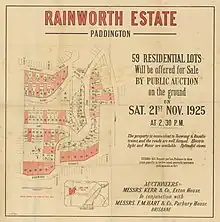
In the 1918 and 1925 the land was sold off for housing; see the 1925 land sale. The Rainworth Estate comprises land between Boundary Road and Rainworth Road south to Birdwood Terrace (formerly Heussler Terrace) and includes the streets of Barton Street, Dudley Street, Nestor Street (now gone), Osman Street (then Margaret Street), Rouen Road, Runic Street, and Vimy Street.
Rainworth State School opened on 2 July 1928.[5][6]
The tram service was extended to Rainworth in 1930 with the Rainworth tram terminus outside the school. The Rainworth tram service was converted to diesel bus operation on 25th December 1962 after the Paddington tram depot was destroyed by fire on 28th September 1962. The reason given for the closure of the tram service was due to the excessive dead mileage the trams were required to undertake to and from the remaining two depots at Light Street and Ipswich Road. The remainder of Brisbane's tram network was shut down on Sunday 13 April 1969. Some heritage-listed tram waiting sheds remain include one opposite 136 Boundary Road.[7]
St Mary's Anglican Church Rainworth was dedicated in 1964 by Archbishop Administrator John Hudson.[8]
Education
Rainworth State School is a government primary (Prep-6) school for boys and girls at 185 Boundary Road (27.4670°S 152.9852°E).[9][10] In 2017, the school had an enrolment of 548 students with 37 teachers (31 full-time equivalent) and 24 non-teaching staff (15 full-time equivalent).[11] The school is listed on the Queensland Heritage Register.[12]
Amenities
St Mary's Anglican Church is at 290 Simpsons Road on the south-eastern corner of the junction of Burnham Street (27.4592°S 152.9741°E).[13]
Rainworth is also home to:
- Rainworth Park on Haining Street
- Norman Buchanan Park (The location of the weekly Bardon Markets on Sundays)
- 'French Tarts' Bakery
- 'Rainworth Seafoods' A fish and chip shop
- 'The Brass Shop Maggins'
References
- "Paddington Ward". Brisbane City Council. Archived from the original on 12 March 2017. Retrieved 12 March 2017.
- "The Gap Ward". Brisbane City Council. Retrieved 19 March 2017.
- "Rainworth – neighbourhood in City of Brisbane (entry 27941)". Queensland Place Names. Queensland Government. Retrieved 4 July 2020.
- "Rainworth – neighbourhood (entry 27941)". Queensland Place Names. Queensland Government. Retrieved 16 May 2017.
- Queensland Family History Society (2010), Queensland schools past and present (Version 1.01 ed.), Queensland Family History Society, ISBN 978-1-921171-26-0
- "NEW STATE SCHOOL". The Telegraph. No. 17, 249. Queensland, Australia. 15 March 1928. p. 14. Retrieved 4 July 2020 – via National Library of Australia.
- "Tram Shelter No. 1 (former)". Brisbane Heritage Register. Brisbane City Council. Retrieved 4 July 2020.
- "Closed Anglican Churches". Anglican Church South Queensland. Archived from the original on 3 April 2019. Retrieved 29 June 2020.
- "State and non-state school details". Queensland Government. 9 July 2018. Archived from the original on 21 November 2018. Retrieved 21 November 2018.
- "Rainworth State School". Archived from the original on 1 July 2004. Retrieved 21 November 2018.
- "ACARA School Profile 2017". Archived from the original on 22 November 2018. Retrieved 22 November 2018.
- "Rainworth State School (entry 650234)". Queensland Heritage Register. Queensland Heritage Council. Retrieved 20 December 2022.
- "Bardon Anglican Church – Set free to serve". Archived from the original on 3 July 2020. Retrieved 3 July 2020.