Radda District
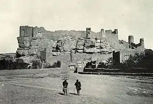
Rada'a District (Arabic: مُدِيْرِيَّة رَدَاع) is a district of the Al Bayda Governorate, Yemen. As of 2003, the district had a population of 56,382 inhabitants. The district's largest city is Rada'a, 49 kilometres (30 mi) east of Dhamar, as the crow flies, a city renowned for its 16th-century ‘Amiryia Madrasa and Mosque.
Rada'a District
مُدِيْرِيَّة رَدَاع | |
|---|---|
 | |
| Country | |
| Governorate | Al Bayda |
| Population (2003) | |
| • Total | 56,382 |
| Time zone | UTC+3 (Yemen Standard Time) |
Climate
| Climate data for Rada'a | |||||||||||||
|---|---|---|---|---|---|---|---|---|---|---|---|---|---|
| Month | Jan | Feb | Mar | Apr | May | Jun | Jul | Aug | Sep | Oct | Nov | Dec | Year |
| Average high °C (°F) | 21.4 (70.5) |
22.7 (72.9) |
24.9 (76.8) |
25.4 (77.7) |
27.2 (81.0) |
29.1 (84.4) |
27.3 (81.1) |
26.2 (79.2) |
26.2 (79.2) |
24.8 (76.6) |
22.0 (71.6) |
21.5 (70.7) |
24.9 (76.8) |
| Daily mean °C (°F) | 12.9 (55.2) |
13.7 (56.7) |
16.5 (61.7) |
17.5 (63.5) |
19.5 (67.1) |
20.7 (69.3) |
21.0 (69.8) |
20.1 (68.2) |
19.2 (66.6) |
17.3 (63.1) |
14.7 (58.5) |
13.7 (56.7) |
17.2 (63.0) |
| Average low °C (°F) | 4.4 (39.9) |
4.7 (40.5) |
8.1 (46.6) |
9.7 (49.5) |
11.8 (53.2) |
12.3 (54.1) |
14.7 (58.5) |
14.0 (57.2) |
12.2 (54.0) |
9.8 (49.6) |
7.5 (45.5) |
5.9 (42.6) |
9.6 (49.3) |
| Average precipitation mm (inches) | 6 (0.2) |
6 (0.2) |
11 (0.4) |
36 (1.4) |
39 (1.5) |
11 (0.4) |
72 (2.8) |
103 (4.1) |
30 (1.2) |
4 (0.2) |
5 (0.2) |
1 (0.0) |
324 (12.6) |
| Source: Climate-Data.org[1] | |||||||||||||
References
External links
Wikimedia Commons has media related to Rada'.

This article is issued from Wikipedia. The text is licensed under Creative Commons - Attribution - Sharealike. Additional terms may apply for the media files.