Mexico City Metro Line 1
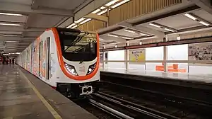
Mexico City Metro Line 1 is one of the twelve metro lines operating in Mexico City, Mexico. Officially inaugurated in 1969, it went to become the first metro line to be built in the country. Its identifying color is pink and it runs through the city from west to east.
| Line 1 / Línea 1 | |||||||||||||||||||||||||||||||||||||||||||||||||||||||||||||||||||||||||||||||||||||||||||||||||||||||||||||||||||||||||||||||||||||||||||||||||||||||||||||||||||||||
|---|---|---|---|---|---|---|---|---|---|---|---|---|---|---|---|---|---|---|---|---|---|---|---|---|---|---|---|---|---|---|---|---|---|---|---|---|---|---|---|---|---|---|---|---|---|---|---|---|---|---|---|---|---|---|---|---|---|---|---|---|---|---|---|---|---|---|---|---|---|---|---|---|---|---|---|---|---|---|---|---|---|---|---|---|---|---|---|---|---|---|---|---|---|---|---|---|---|---|---|---|---|---|---|---|---|---|---|---|---|---|---|---|---|---|---|---|---|---|---|---|---|---|---|---|---|---|---|---|---|---|---|---|---|---|---|---|---|---|---|---|---|---|---|---|---|---|---|---|---|---|---|---|---|---|---|---|---|---|---|---|---|---|---|---|---|---|---|
 Observatorio terminal | |||||||||||||||||||||||||||||||||||||||||||||||||||||||||||||||||||||||||||||||||||||||||||||||||||||||||||||||||||||||||||||||||||||||||||||||||||||||||||||||||||||||
| Overview | |||||||||||||||||||||||||||||||||||||||||||||||||||||||||||||||||||||||||||||||||||||||||||||||||||||||||||||||||||||||||||||||||||||||||||||||||||||||||||||||||||||||
| Locale | Mexico City | ||||||||||||||||||||||||||||||||||||||||||||||||||||||||||||||||||||||||||||||||||||||||||||||||||||||||||||||||||||||||||||||||||||||||||||||||||||||||||||||||||||||
| Termini | |||||||||||||||||||||||||||||||||||||||||||||||||||||||||||||||||||||||||||||||||||||||||||||||||||||||||||||||||||||||||||||||||||||||||||||||||||||||||||||||||||||||
| Connecting lines | |||||||||||||||||||||||||||||||||||||||||||||||||||||||||||||||||||||||||||||||||||||||||||||||||||||||||||||||||||||||||||||||||||||||||||||||||||||||||||||||||||||||
| Stations | 20 | ||||||||||||||||||||||||||||||||||||||||||||||||||||||||||||||||||||||||||||||||||||||||||||||||||||||||||||||||||||||||||||||||||||||||||||||||||||||||||||||||||||||
| Service | |||||||||||||||||||||||||||||||||||||||||||||||||||||||||||||||||||||||||||||||||||||||||||||||||||||||||||||||||||||||||||||||||||||||||||||||||||||||||||||||||||||||
| Type | Rapid transit | ||||||||||||||||||||||||||||||||||||||||||||||||||||||||||||||||||||||||||||||||||||||||||||||||||||||||||||||||||||||||||||||||||||||||||||||||||||||||||||||||||||||
| System | Mexico City Metro | ||||||||||||||||||||||||||||||||||||||||||||||||||||||||||||||||||||||||||||||||||||||||||||||||||||||||||||||||||||||||||||||||||||||||||||||||||||||||||||||||||||||
| Operator(s) | Sistema de Transporte Colectivo (STC) | ||||||||||||||||||||||||||||||||||||||||||||||||||||||||||||||||||||||||||||||||||||||||||||||||||||||||||||||||||||||||||||||||||||||||||||||||||||||||||||||||||||||
| Rolling stock | NM-83, NE-92, NM-16 NM-73AR | ||||||||||||||||||||||||||||||||||||||||||||||||||||||||||||||||||||||||||||||||||||||||||||||||||||||||||||||||||||||||||||||||||||||||||||||||||||||||||||||||||||||
| Ridership | 665,171 passengers per day (2019)[1] | ||||||||||||||||||||||||||||||||||||||||||||||||||||||||||||||||||||||||||||||||||||||||||||||||||||||||||||||||||||||||||||||||||||||||||||||||||||||||||||||||||||||
| History | |||||||||||||||||||||||||||||||||||||||||||||||||||||||||||||||||||||||||||||||||||||||||||||||||||||||||||||||||||||||||||||||||||||||||||||||||||||||||||||||||||||||
| Opened | 4 September 1969 | ||||||||||||||||||||||||||||||||||||||||||||||||||||||||||||||||||||||||||||||||||||||||||||||||||||||||||||||||||||||||||||||||||||||||||||||||||||||||||||||||||||||
| Technical | |||||||||||||||||||||||||||||||||||||||||||||||||||||||||||||||||||||||||||||||||||||||||||||||||||||||||||||||||||||||||||||||||||||||||||||||||||||||||||||||||||||||
| Line length | 16.654 km (10 mi) | ||||||||||||||||||||||||||||||||||||||||||||||||||||||||||||||||||||||||||||||||||||||||||||||||||||||||||||||||||||||||||||||||||||||||||||||||||||||||||||||||||||||
| Track length | 18.828 km (12 mi) | ||||||||||||||||||||||||||||||||||||||||||||||||||||||||||||||||||||||||||||||||||||||||||||||||||||||||||||||||||||||||||||||||||||||||||||||||||||||||||||||||||||||
| Track gauge | 1,435 mm (4 ft 8+1⁄2 in) standard gauge with roll ways along track | ||||||||||||||||||||||||||||||||||||||||||||||||||||||||||||||||||||||||||||||||||||||||||||||||||||||||||||||||||||||||||||||||||||||||||||||||||||||||||||||||||||||
| Electrification | Guide bars | ||||||||||||||||||||||||||||||||||||||||||||||||||||||||||||||||||||||||||||||||||||||||||||||||||||||||||||||||||||||||||||||||||||||||||||||||||||||||||||||||||||||
| Operating speed | 36 km/h (22 mph) | ||||||||||||||||||||||||||||||||||||||||||||||||||||||||||||||||||||||||||||||||||||||||||||||||||||||||||||||||||||||||||||||||||||||||||||||||||||||||||||||||||||||
| |||||||||||||||||||||||||||||||||||||||||||||||||||||||||||||||||||||||||||||||||||||||||||||||||||||||||||||||||||||||||||||||||||||||||||||||||||||||||||||||||||||||
General information
The line is built under several avenues: Parque Lira, Pedro Antonio de los Santos, Circuito Interior, Avenida de los Insurgentes, Avenida Chapultepec, Arcos de Belén, Balderas, Eje Central Lázaro Cárdenas, José María Izazaga, Isabel la Católica, Anillo de Circunvalación, Congreso de la Unión, Eduardo Molina, and Ignacio Zaragoza.
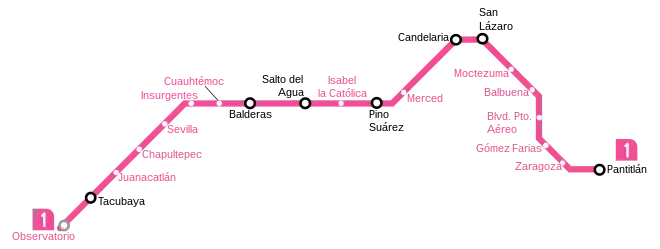
It commutes with Lines 7 and 9 at the Station Tacubaya, Line 3 at Balderas, Line 8 at Salto del Agua, Line 2 at Pino Suárez, Line 4 at Candelaria, Line B at San Lázaro and Lines 5, 9 and A at Pantitlán. When Line 12 extension is completed, it will also connect with Line 12 at Observatorio.[2]
History
.jpg.webp)
The first section of Line 1 was opened on 4 September 1969 as part of Mexico City Metro's first construction stage, it was inaugurated by Gustavo Díaz Ordaz, President of Mexico from 1964 to 1970, and Alfonso Corona del Rosal, Regent of the Federal District Department.[3] The inauguration ceremony took place at the Insurgentes station.[4]
The next day the line was opened to the public. To the original route (Chapultepec–Zaragoza) a new station, Juanacatlán, was added to the west on 11 April 1970, and the first correspondencia (a transfer station) became functional on 1 August 1970 when Line 2 was opened. The two westernmost stations Tacubaya and current terminal Observatorio were inaugurated on 20 November 1970 and 10 June 1972 respectively.
Station Pantitlán was opened on 22 August 1984 as the eastern terminal during a fourth and final expansion. All twenty stations have operated since then, running a total track length of 18.83 km (11.70 mi), of which 16.65 km (10.35 mi) are passenger track. The 1 is the only line in the network that is fully underground except for some surface track in Observatorio used for maintenance.
As of 2020, an extension of Line 12 is under construction, this stretch will connect Line 12 with Line 1 at the Observatorio station.[2]

Authorities warned on 10 August 2020 that Line 1 is in danger of a major fire due to an aging electrical system that is in need of major improvements. Lines 1, 2, and 3 report an average of 2.5 electrical failures daily.[5] As a result, the line started undergo renovations that require its closure. The first closure was from Pantitlán to Salto de Agua stations starting on 11 July 2022 and it was expected to conclude in March 2023. The second closure was expected to start in March 2023 from Balderas to Observatorio stations and was expected to conclude in August 2023. During both periods, all railway elements will be replaced with modern material, the wiring will be replaced, damage due to leaks and cracks will be repaired, stations that are not yet modernized will be updated, and accessibility will be added to stations that lack it.[6][7] The first stage renovation works continue as of October 2023.
In April 2023, Siemens Mobility claimed that they would install CBTC on Line 1.[8]
Chronology
- September 4, 1969: from Chapultepec to Zaragoza.
- April 11, 1970: from Chapultepec to Juanacatlán.
- November 20, 1970: from Juanacatlán to Tacubaya.
- June 10, 1972: from Tacubaya to Observatorio.
- August 22, 1984: from Zaragoza to Pantitlán.
Rolling stock
Line 1 has had different types of rolling stock throughout the years.
- Alstom MP-68, 1969–2018
- Concarril NM-73, since 1978
- Alstom MP-82, 1985–1994
- Concarril NM-83, 1989–2018
- CAF NE-92, 1994–2018
- Bombardier NC-82, 2006–2007
- Concarril NM-79, 2011–2012
- CAF NM-16, since 2019
Currently, out of the 390 trains in the Mexico City Metro network, 49 are in service in Line 1.[9]
Station list
| Denotes a partially accessible station | |
| Denotes a fully accessible station | |
| Denotes a metro transfer | |
| Denotes a connection with the Centro de transferencia modal (CETRAM) system | |
| Denotes a connection with the Ecobici system | |
| Denotes a connection with the Metrobús system | |
| Denotes a connection with the Mexibús system | |
| Denotes a connection with the public bus system | |
| Denotes a connection with the Red de Transporte de Pasajeros (RTP) system | |
| Denotes a connection with the Trolleybus system |
The stations from west to east:


| No. | Station | Date opened | Level | Distance (km) | Connection | Location | |
|---|---|---|---|---|---|---|---|
| Between stations |
Total | ||||||
| 01 | Pantitlán |
August 22, 1984 | Underground trench |
- | 0.0 |
|
Venustiano Carranza |
| 02 | Zaragoza |
September 4, 1969 | 1.5 | 1.5 |
| ||
| 03 | Gomez Farías |
0.9 | 2.4 |
| |||
| 04 | Boulevard Puerto Aéreo |
0.7 | 3.1 |
| |||
| 05 | Balbuena |
0.8 | 3.9 |
| |||
| 06 | Moctezuma |
0.8 | 4.7 |
| |||
| 07 | San Lázaro |
0.7 | 5.4 |
| |||
| 08 | Candelaria | 1.1 | 6.4 |
| |||
| 09 | Merced |
0.9 | 7.3 |
| |||
| 10 | Pino Suárez |
0.8 | 8.2 |
|
Cuauhtémoc | ||
| 11 | Isabel la Católica |
0.5 | 8.7 |
| |||
| 12 | Salto del Agua |
0.6 | 9.3 |
| |||
| 13 | Balderas |
0.6 | 9.9 |
| |||
| 14 | Cuauhtémoc |
0.5 | 10.5 |
| |||
| 15 | Insurgentes |
0.9 | 11.4 |
| |||
| 16 | Sevilla |
0.8 | 12.2 |
| |||
| 17 | Chapultepec | Underground two-story trench |
0.6 | 12.9 |
| ||
| 18 | Juanacatlán |
April 11, 1970 | 1.1 | 14.0 |
|
Miguel Hidalgo | |
| 19 | Tacubaya |
November 20, 1970 | Underground multi-story trench |
1.3 | 15.2 |
| |
| 20 | Observatorio |
June 10, 1972 | Hillside trench | 1.4 | 16.7 |
(under construction) |
Álvaro Obregón |
Renamed stations
| Date | Old name | New name |
|---|---|---|
| 1997 | Aeropuerto | Boulevard Puerto Aéreo |
Ridership
The following table shows each of Line 1 stations total and average daily ridership during 2019.[1]
| † | Transfer station |
| ‡ | Terminal |
| †‡ | Transfer station and terminal |
| Rank | Station | Total ridership | Average daily |
|---|---|---|---|
| 1 | Observatorio‡ | 26,388,110 | 72,296 |
| 2 | Insurgentes | 20,753,676 | 56,859 |
| 3 | Chapultepec | 19,388,677 | 53,120 |
| 4 | Merced | 18,129,244 | 49,669 |
| 5 | Pantitlán†‡ | 17,860,457 | 48,933 |
| 6 | Zaragoza | 16,963,497 | 46,475 |
| 7 | Tacubaya† | 12,369,808 | 33,890 |
| 8 | San Lázaro† | 11,915,094 | 32,644 |
| 9 | Pino Suárez† | 11,456,022 | 31,386 |
| 10 | Sevilla | 11,123,527 | 30,475 |
| 11 | Gómez Farías | 10,360,851 | 28,386 |
| 12 | Candelaria† | 8,554,561 | 23,437 |
| 13 | Boulevard Puerto Aéreo | 8,429,972 | 23,096 |
| 14 | Cuauhtémoc | 8,311,511 | 22,771 |
| 15 | Isabel la Católica | 8,262,282 | 22,636 |
| 16 | Moctezuma | 8,050,035 | 22,055 |
| 17 | Balderas† | 7,825,656 | 21,440 |
| 18 | Salto del Agua† | 7,482,564 | 20,500 |
| 19 | Balbuena | 4,902,639 | 13,432 |
| 20 | Juanacatlán | 4,259,229 | 11,669 |
| Total | 242,787,412 | 665,171 | |
Tourism
Line 1 passes near several places of interest.
- Bosque de Chapultepec, city park
- Museo de Arte Moderno, museum of modern art
- Chapultepec Castle
- Heroic Cadets Memorial, a monument dedicated to the memory of the Niños Héroes
- Chapultepec Zoo
- Estela de Luz, a monument that commemorates the bicentenary of Mexico's independence
- Paseo de la Reforma, emblematic avenue of Mexico City
- Diana the Huntress Fountain, a monumental fountain of Diana located at Paseo de la Reforma
- Angel of Independence, a victory column on a roundabout on the major thoroughfare of Paseo de la Reforma
- Zona Rosa, a neighborhood known for its shopping centers, nightlife, gay community, and Korean community
- Historic center of Mexico City
See also
Notes and references
- The following list was adapted from different websites and official maps.
- Metro (
_version_2019.svg.png.webp) ) connections obtained from the official Mexico City Metro system map.[10]
) connections obtained from the official Mexico City Metro system map.[10] - Accessibility obtained from the Mexico City Metro system map. In some cases, the map omits the accessibility icon as the station(s) are actually partially accessible. However, the respective websites of each station on the official site indicate the respective accessibility methods. Stations with the symbol
 ‡ are fully accessible; stations with the symbol
  † are partially accessible.[10]
 - Centro de transferencia modal (CETRAM;
_%C3%93rgano_Regulador_de_Transporte_(CETRAM).svg.png.webp) ) obtained from the official website of the Órgano Regulador de Transporte.[11]
) obtained from the official website of the Órgano Regulador de Transporte.[11] - Ecobici (
_EcoBici.svg.png.webp) ) obtained from their official website.[12]
) obtained from their official website.[12] - Metrobús (
 ) obtained from the Mexico City Metrobús system map.[13]
 - Mexibús (
.svg.png.webp) ) obtained from the official Mexico City Metro system map.[10]
) obtained from the official Mexico City Metro system map.[10] - Public buses network (peseros) (
_Red_de_Autobuses_de_la_CDMX.svg.png.webp) ) obtained from the official website of the Órgano Regulador de Transporte.[14]
) obtained from the official website of the Órgano Regulador de Transporte.[14] - Red de Transporte de Pasajeros (
 ) obtained from their official website.[15]
 - Trolleybuses (
 ) obtained from their official website.[16]
- Metro (
- "Afluencia de estación por línea 2019" (in Spanish). Metro CDMX. Retrieved 25 April 2020.
- "Ampliarán Línea 12 del Metro del DF". Sipse (in Spanish). February 14, 2013. Retrieved July 27, 2018.
- "Línea 1 del Metro renueva el transporte capitalino". El Universal (in Spanish). September 4, 2016. Retrieved August 13, 2018.
- "El origen del Metro del DDF". siempre.mx (in Spanish). Revista Siempre. 4 September 2018. Retrieved 4 April 2020.
- "Advierten sobre riesgo de incendio en Línea 1 del Metro". El Universal (in Spanish). 20 August 2020. Retrieved August 20, 2020.
- Yeferson, Armando (28 June 2022). "Accesibilidad incluyente será del 100% en la Línea 1 del Metro: Calderón Aguilera". 24 Horas (in Spanish). Retrieved 10 July 2022.
- López, Alejandro I. (9 July 2022). "Línea 1 del metro de Ciudad de México: cuándo cierra, rutas y alternativas de transporte". El País (in Spanish). Retrieved 10 July 2022.
- Siemens Mobility. "El CBTC en Línea 1 del Metro CDMX" (PDF) (in Spanish). Asociación Mexicana de Ferrocarriles.
- http://www.metro.cdmx.gob.mx/operacion/parque-vehicular Parque vehicular (Rolling stock)
- "Mi Mapa Metro 22032021" [My Metro Map 22032021] (PDF) (in Spanish). Sistema Transporte Colectivo Metro. 22 March 2021. Retrieved 30 October 2021.
- "Centros de Transferencia Modal (CETRAM)" [Modal Transfer Centers] (in Spanish). Órgano Regulador de Transporte. Retrieved 30 October 2021.
- "Mapa de disponibilidad" [Disponibility map] (in Spanish). Ecobici. Retrieved 30 October 2021.
- "Mapa del sistema" [System map] (in Spanish). Mexico City Metrobús. Retrieved 30 October 2021.
- "Red de corredores" [Route network] (in Spanish). Retrieved 30 October 2021.
- "Red de Rutas" [Routes network] (in Spanish). Red de Transporte de Pasajeros. Retrieved 30 October 2021.
- "Servicios" [Services] (in Spanish). Servicio de Transportes Eléctricos. Retrieved 30 October 2021.