Petleshkov Hill
Petleshkov Hill (Bulgarian: Петлешков хълм, ‘Petleshkov Halm’ \pet-'lesh-kov 'h&lm\) is the ice-covered hill rising to 221 m in northwestern Astrolabe Island in Bransfield Strait, Antarctica. It surmounts Mokren Bight to the south.
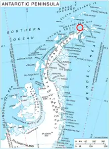
Location of Astrolabe Island in the Antarctic Peninsula region
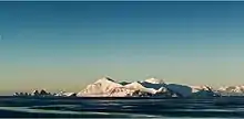
Northwest view of Astrolabe Island roughly centred on Petleshkov Hill, with Drumohar Peak on the left and Rogach Peak in the background
The feature is “named after Vasil Petleshkov (1845-1876), a leader of the 1876 April Uprising for Bulgarian independence, in connection with the settlement of Petleshkovo in Northeastern Bulgaria.”[1]
Location
Petleshkov Hill is located at 63°18′35″S 58°43′30″W, which is 1.2 km northeast of Damga Point, 1.32 km southeast of Raduil Point and 2.15 km west of Drumohar Peak. German-British mapping in 1996.
Maps
- Trinity Peninsula. Scale 1:250000 topographic map No. 5697. Institut für Angewandte Geodäsie and British Antarctic Survey, 1996.
- Antarctic Digital Database (ADD). Scale 1:250000 topographic map of Antarctica. Scientific Committee on Antarctic Research (SCAR). Since 1993, regularly upgraded and updated.
References
- Petleshkov Hill. SCAR Composite Gazetteer of Antarctica.
- Bulgarian Antarctic Gazetteer. Antarctic Place-names Commission. (details in Bulgarian, basic data in English)
External links
- Petleshkov Hill. Copernix satellite image
This article includes information from the Antarctic Place-names Commission of Bulgaria which is used with permission.
This article is issued from Wikipedia. The text is licensed under Creative Commons - Attribution - Sharealike. Additional terms may apply for the media files.