4th arrondissement of Paris
The 4th arrondissement of Paris (IVe arrondissement) is one of the twenty arrondissements of the capital city of France. In spoken French, this arrondissement is referred to as quatrième. Along with the 1st, 2nd and 3rd arrondissements, it is in the first sector of Paris, which maintains a single local government rather than four separate ones.
4th arrondissement of Paris | |
|---|---|
 Notre-Dame, on the Île de la Cité | |
 Coat of arms | |
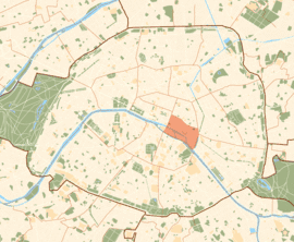
 Location within Paris | |
| Coordinates: 48°51′20″N 2°21′20″E | |
| Country | France |
| Region | Île-de-France |
| Department | Paris |
| Commune | Paris |
| Government | |
| • Mayor (2020–2026) | Ariel Weil (PS) |
| Area | 1.60 km2 (0.62 sq mi) |
| Population | 29,064 |
| • Density | 18,165/km2 (47,050/sq mi) |
| INSEE code | 75104 |
 Paris Coat of Arms 20 arrondissements of Paris | |||||||||||||||||||||||||||||||||||||
|---|---|---|---|---|---|---|---|---|---|---|---|---|---|---|---|---|---|---|---|---|---|---|---|---|---|---|---|---|---|---|---|---|---|---|---|---|---|
|
|||||||||||||||||||||||||||||||||||||
The arrondissement, also known as Hôtel-de-Ville, is situated on the right bank of the River Seine. It contains the Renaissance-era Paris City Hall, rebuilt between 1874 and 1882.[2] It also contains the Renaissance square of Place des Vosges, the overtly modern Pompidou Centre, and the lively southern part of the medieval district of Le Marais, which today is known for being the gay district of Paris. (The quieter northern part of Le Marais is within the 3rd arrondissement). The eastern part of the Île de la Cité (including Notre-Dame de Paris) and all of the Île Saint-Louis are also included within the 4th arrondissement.
The 4th arrondissement is known for its little streets, cafés, and shops but is often regarded by Parisians as expensive and congested. It has old buildings and a mix of many cultures.
Geography
With a land area of 1.601 km2 (0.618 sq.miles, or 396 acres), the 4th arrondissement is the third smallest arrondissement in the city.
It is bordered to the west by the 1st arrondissement, to the north by the 3rd, to the east by the 11th and 12th, and to the south by the Seine and the 5th.
Demographics
The peak of population of the 4th arrondissement occurred before 1861, though the arrondissement was defined in its current shape only since the re-organization of Paris in 1860. In 1999, the population was 30,675, and the arrondissement hosted 41,424 jobs.
Historical population
| Year (of French censuses) |
Population | Density (inh. per km²) |
|---|---|---|
| 1861 (peak of population)¹ | 108,520 | 67,783 |
| 1872 | 95,003 | 59,377 |
| 1954 | 70,944 | 41,638 |
| 1962 | 61,670 | 38,520 |
| 1968 | 54,029 | 33,747 |
| 1975 | 40,466 | 25,275 |
| 1982 | 33,990 | 21,230 |
| 1990 | 32,226 | 20,129 |
| 1999 | 30,675 | 19,160 |
| 2009 | 28,192 | 17,620 |
¹The peak of population in this area occurred before 1861, but the
arrondissement was created in 1860, so there are not accurate figures before 1861.
Immigration
| Born in metropolitan France | Born outside metropolitan France | |||
|---|---|---|---|---|
| 78.1% | 21.9% | |||
| Born in overseas France |
Born in foreign countries with French citizenship at birth1 | EU-15 immigrants2 | Non-EU-15 immigrants | |
| 0.7% | 4.8% | 5.6% | 10.8% | |
| 1 This group is made up largely of former French settlers, such as Pieds-Noirs in Northwest Africa, followed by former colonial citizens who had French citizenship at birth (such as was often the case for the native elite in French colonies), as well as to a lesser extent foreign-born children of French expatriates. A foreign country is understood as a country not part of France in 1999, so a person born for example in 1950 in Algeria, when Algeria was an integral part of France, is nonetheless listed as a person born in a foreign country in French statistics. 2 An immigrant is a person born in a foreign country not having French citizenship at birth. An immigrant may have acquired French citizenship since moving to France, but is still considered an immigrant in French statistics. On the other hand, persons born in France with foreign citizenship (the children of immigrants) are not listed as immigrants. | ||||
History

The Île de la Cité has been inhabited since the 1st century BC, when it was occupied by the Parisii tribe of the Gauls. The Right Bank was first settled in the 5th century.
Since the end of the 19th century, le Marais has been populated by a significant Jewish population, the Rue des Rosiers being at the heart of its community. There are a handful of kosher restaurants, and Jewish institutions. Since the 1990s, gay culture has influenced the arrondissement, with new residents opening a number of bars and cafés in the area by the town hall.
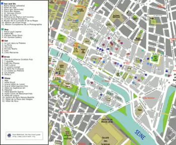
Map

Cityscape

Places of interest in the arrondissement

- Bazar de l'Hôtel de Ville department store
- Berthillon
- Bibliothèque de l'Arsenal
- Centre Georges Pompidou
- Hôtel-Dieu hospital
- Hôtel de Sens
- Hôtel de Sully, on the site of a former orangery
- Hôtel de Ville
- Le Marais
- Rue des Rosiers
- Lycée Charlemagne
- Maison européenne de la photographie
- Marché aux fleurs, Place Louis Lépine
- Mémorial de la Shoah
- Musée Boleslas Biegas, Musée Adam Mickiewicz, and Salon Frédéric Chopin
- Musée de la Magie
- Notre-Dame de Paris
- Pavillon de l'Arsenal
- Prefecture of Police
- Quai des Célestins
- Saint-Jacques Tower
- St-Gervais-et-St-Protais Church
- Saint-Louis-en-l'Île Church
- Salle des Traditions de la Garde Républicaine
- Former Temple, fortress and later prison
- Temple du Marais
- Église Saint-Merri
Main streets and squares
- Place de la Bastille (shared with the 11th and 12th arrondissements), including the July Column (Colonne de juillet)
- Place de l'Hôtel de Ville, formerly Place de Grève
- Place des Vosges (shared with the 3rd arrondissement)
- Place du Châtelet (shared with the 1st arrondissement)
- Place Saint-Gervais, outside the doors of the St-Gervais-et-St-Protais Church
- Rue de Rivoli (shared with the 1st arrondissement)
- Square Barye
Education
Lycée Charlemagne is located in the arrondissement, as well as Haredi Jewish institutions Yad Mordekhai.[3]
Transport
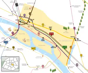
Metro stations within, partially or fully, the 4th arrondissement:
References
- "Populations légales 2020". The National Institute of Statistics and Economic Studies. 29 December 2022.
- "Hotel de Ville, the Paris City Hall". Paris Digest. 2018. Archived from the original on 2019-09-24. Retrieved 2018-11-20.
- "Groupe scolaire Yad Mordekhai Projet". yadmordekhai.com. Retrieved 2019-06-06.
External links
- The official guide, partner of the Paris Tourist office
 4th arrondissement travel guide from Wikivoyage
- Site of the Mayor of the 4th arrondissement (in French)
- L'Indépendant du 4e Posts in English by an inhabitants of the 4th arrondissement since 2008 : dailylife, history, heritage,...
- News on Marais in Paris