Puerto Rico Highway 18
Puerto Rico Highway 18 (PR-18) is a freeway in Puerto Rico, which is also known as Expreso Las Américas. It runs from its north end at its intersection with PR-22 (known as Expreso José de Diego) in San Juan to its south end in Río Piedras where it intersects with PR-1.[2] At this point PR-18 becomes PR-52, known as Autopista Luis A. Ferré.[3]
Highway 18 | ||||
|---|---|---|---|---|
| Ruta 18 | ||||
| Expreso Las Américas | ||||
| Route information | ||||
| Maintained by Puerto Rico DTPW | ||||
| Length | 6.09 km[1] (3.78 mi) | |||
| Existed | 1961–present | |||
| Major junctions | ||||
| South end | ||||
| ||||
| North end | ||||
| Location | ||||
| Country | United States | |||
| Territory | Puerto Rico | |||
| Municipalities | San Juan | |||
| Highway system | ||||
| ||||

Route description
PR-18 connects PR-52 to PR-22 and intersects with Jesus de Piñero Avenue (PR-17), Franklin Delano Roosevelt Avenue (PR-23), which grants access to Plaza Las Américas, and Domenech Avenue. It is mostly a 4-lane road in each direction. The combined route of PR-18 and PR-52 is coterminous with the unsigned Interstate Highway PRI-1.
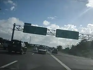 PR-18 begins from PR-22
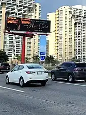 PR-18 north in Hato Rey Norte barrio
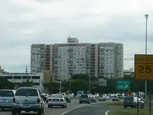 PR-18 south in Gobernador Piñero barrio
Exit list
The entire route is located in San Juan.
 PR-18 south at exit 1C to PR-23 east
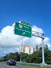 PR-18 north at exit 3A to PR-17 west
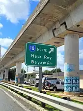 PR-21 west at its junction with PR-18 north
| Location | km[4] | mi | Exit | Destinations | Notes | |
|---|---|---|---|---|---|---|
| Monacillo Urbano | 6.09 | 3.78 | 8B | Southern terminus of PR-18; PRI-1 continues southbound via PR-52. | ||
| 5.9 | 3.7 | 8A | No southbound access to PR-1 north. | |||
| 4.7 | 2.9 | 7B | No northbound exit. | |||
| 4.5 | 2.8 | 7A | Access to Centro Médico station | |||
| El Cinco | 4.2 | 2.6 | 6B | Most direct access to the hospital; southbound only. | ||
| 3.5 | 2.2 | 6A | ||||
| Gobernador Piñero | 2.7 | 1.7 | 5B | Access to The Mall of San Juan and Piñero station | ||
| 2.4 | 1.5 | 5A | ||||
| Hato Rey Norte | 2.0 | 1.2 | 4 | Access to Hospital del Maestro and Domenech station | ||
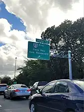
| 1.5– 0.5 | 0.93– 0.31 | 3A–C | Frontage roads of these exits has an at-grade intersection in Chardon Street; Access to Plaza Las Americas shopping mall and Roosevelt station | |||
| 0.0 | 0.0 | 0 | Northern terminus of PR-18 and PRI-1; PR-22 exit 2A; access to Fernando Luis Ribas Dominicci Airport | |||
1.000 mi = 1.609 km; 1.000 km = 0.621 mi
| ||||||
References
- Guía de Carreteras Principales, Expresos y Autopistas. Departamento de Transportación y Obras Publicas de Puerto Rico. 2019. Accessed 3 May 2019.
- Puerto Rico Department of Transportation and Public Works. "Datos de Transito 2000-2009" (in Spanish). Archived from the original on 1 April 2019. Retrieved 28 February 2020.
- National Geographic Maps (2011). Puerto Rico (Map). 1:125,000. Adventure Map (Book 3107). Evergreen, Colorado: National Geographic Maps. ISBN 978-1566955188. OCLC 756511572.
- Google (28 February 2020). "PR-18" (Map). Google Maps. Google. Retrieved 28 February 2020.
External links
 Media related to Puerto Rico Highway 18 at Wikimedia Commons
| Signed | |
|---|---|
| Unsigned | |
| Lists | |
| Other | |
Routes in italics are no longer a part of the system. Major Interstates are highlighted. | |
This article is issued from Wikipedia. The text is licensed under Creative Commons - Attribution - Sharealike. Additional terms may apply for the media files.