Pădurea Craiului Mountains
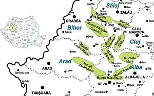
The Pădurea Craiului Mountains are in the northwestern part of the Apuseni Mountains of the Carpathian Mountain range, located between the Vad-Borod Depression and the Beiuș Depression. The Dealurile Vestice (Western Hills) are located to the west of these mountains, the Vlădeasa Mountains are to their south-east, and the Plopiș Mountains are to their north. The highest peak in Pădurea Craiului is the Hodrâncușa Peak at 1,027 metres (3,369 ft). The name Pădurea Craiului literally means "The Forest of the King".
_1.jpg.webp)


The mountains cover an area of 1,150 km2 (440 sq mi) and are located in the central-eastern part of Bihor County, covering 15.2% of its surface area. They are also the mountainous area nearest to Oradea, which is about 35 km (22 mi) away from Vârciorog, and 60 km (37 mi) away of Șuncuiuș, two communes nestled in the Pădurea Craiului.
External links
- "Munții Pădurea Craiului – ghid turistic", padureacraiului.x7.ro (in Romanian), retrieved November 10, 2021