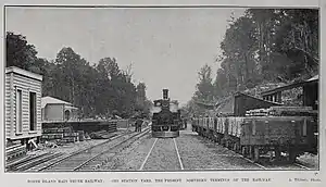
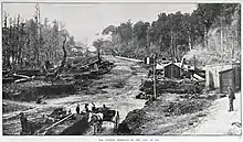
Oio railway station
Oio was a station on the North Island Main Trunk line,[1] in the Ruapehu District of New Zealand. It served the hamlet of Oio, which lay to the north of the station.[2] It was 8.29 km (5.15 mi) north of Raurimu and 5.64 km (3.50 mi) south of Ōwhango. It was one of the many temporary railheads along the route, with work going on from 1904 to 1908.
Oio railway station | |||||||||||
|---|---|---|---|---|---|---|---|---|---|---|---|
 Oio station yard in 1906 | |||||||||||
| General information | |||||||||||
| Location | New Zealand | ||||||||||
| Coordinates | 39.053594°S 175.379797°E | ||||||||||
| Elevation | 465 m (1,526 ft) | ||||||||||
| Line(s) | North Island Main Trunk | ||||||||||
| Distance | Wellington 367.19 km (228.16 mi) | ||||||||||
| History | |||||||||||
| Opened | 1905 | ||||||||||
| Closed | 28 August 1972 | ||||||||||
| Electrified | June 1988 | ||||||||||
| Services | |||||||||||
| |||||||||||
The Public Works Department transferred the station to NZ Railways on 9 November 1908,[1] though a road had been built in 1904,[3] by March 1905 a station yard was being formed[4] and by April 1906 it was the railhead, with a pumice road to Makatote. By then trains were bringing ballast,[5] platelaying was in progress[6] and the track stretched half way to Raurimu, having been realigned due to a slip and crossing an embankment into a 70 ft (21 m) cutting, which was being cut. An unnamed stream, then called the Waikohatu River, was to be bridged and pile-driving was in progress for a 276 ft (84 m) bridge over Piopiotea Stream, the bridge girders being made in Auckland by Fraser and Co.[7] The bridge has since been replaced in concrete.[8] By 10 May 1907 goods could reach Raurimu by rail.[4]

By 20 March 1908 Oio had a passing loop for 58 wagons, a 200 ft (61 m) x 20 ft (6.1 m) passenger platform, a 22 ft (6.7 m) x 9 ft (2.7 m) shelter shed, with lobby and store, a tablet office, a loading bank, cattle yards and pens, a 30 ft (9.1 m) x 20 ft (6.1 m) goods shed with verandah, privies, urinals and a water tank of 2,000 imp gal (9.1 m3) supplying water by gravity. A 6th class station and cart approach to the platform were added by 10 November 1908.[4]
Houses for railway workers were built between 1908 and 1926,[4] the population of Oio being 102 by 1916.[9]
Oio was one of 3 stations with the shortest (three-letter) names in New Zealand, along with Ava in Wellington and Tui in the Nelson Region. The name may be a contraction of ioio (muscular), or puioio (a tree knot).[10]
Oio closed to passengers on 5 July 1970[1] and to freight on 28 August 1972.[4]
Manson's Siding
Manson & Clark put in a siding, 2 mi 28 ch (3.8 km) south of Oio, between 1915[11] and 1917[4] to serve their timber mill, which had a tramway running to the north west.[12] The mill, described as United Sawmills in 1932,[13] burnt down in 1937[14] and the siding closed on 3 April 1949.[4] The name remains as a road and a locality.[15]
Incidents
A train was stuck in a washout a mile south of Oio in 1933.[16] Trains were delayed by a washout at Mansons Siding in 1940.[17] A goods train was partly derailed in a cutting near Mansons Siding in heavy rain in 1941.[18] A 1945 washout injured 2 passengers[19] and derailed 6 coaches of the Night Limited, just north of Mansons Siding.[20]
RM 30 collided with a velocipede between Raurimu and Oio on 28 January 1982.[21]
On 7 August 1991, after striking a washout near Mansons Siding,[22] driver Graeme Peter Orange died and EF class locomotives 30036 and 30088 were later scrapped.[23] A memorial was placed there[24] and in 2017 a train stopped at the washout site in tribute.[25]
References
- Scoble, Juliet. "Names & Opening & Closing Dates of Railway Stations in New Zealand 1863 to 2010" (PDF). Rail Heritage Trust of New Zealand.
- "Sheet: WN8". www.mapspast.org.nz. 1928. Retrieved 26 September 2020.
- Parliamentary Debates. 1904.
- "Stations" (PDF). NZR Rolling Stock Lists. Retrieved 10 August 2020.
- "WELLINGTON TO AUCKLAND. NEW ZEALAND MAIL". paperspast.natlib.govt.nz. 11 April 1906. Retrieved 27 September 2020.
- Parliament, New Zealand (1906). Parliamentary Debates.
- "WELLINGTON TO AUCKLAND. NEW ZEALAND TIMES". paperspast.natlib.govt.nz. 3 April 1906. Retrieved 26 September 2020.
- "RM 31 Heads North". nzrailphotos.co.nz. 23 February 2019. Retrieved 26 September 2020.
- "REPORT ON THE RESULTS OF A CENSUS OF THE POPULATION OF THE DOMINION OF NEW ZEALAND TAKEN FOR THE NIGHT OF THE 15th OCTOBER, 1916". www3.stats.govt.nz. Retrieved 27 September 2020.
- "Poro-o-Tärao". nzetc.victoria.ac.nz. Retrieved 27 September 2020.
- "KAITIEKE COUNTY COUNCIL. TAIHAPE DAILY TIMES". paperspast.natlib.govt.nz. 9 July 1915. Retrieved 27 September 2020.
- New Zealand Railway and Tramway Atlas (Fourth ed.). Quail Map Co. 1993. ISBN 0-900609-92-3.
- "WEST COAST NOTES. PRESS". paperspast.natlib.govt.nz. 6 February 1932. Retrieved 27 September 2020.
- "DISASTROUS FIRE. KING COUNTRY CHRONICLE". paperspast.natlib.govt.nz. 17 June 1937. Retrieved 27 September 2020.
- "Mansons Siding, Manawatu-Wanganui". NZ Topo Map. Retrieved 27 September 2020.
- "MISHAPS TO EXPRESSES, WAIKATO TIMES". paperspast.natlib.govt.nz. 22 March 1933. Retrieved 27 September 2020.
- "TRAIN TRAVELLERS. EVENING POST". paperspast.natlib.govt.nz. 26 February 1940. Retrieved 27 September 2020.
- "TRAIN DERAILED. NEW ZEALAND HERALD". paperspast.natlib.govt.nz. 29 May 1941. Retrieved 27 September 2020.
- "MAIN TRUNK LINE. NEW ZEALAND HERALD". paperspast.natlib.govt.nz. 8 January 1945. Retrieved 27 September 2020.
- "MAIN TRUNK OPEN. EVENING POST". paperspast.natlib.govt.nz. 9 January 1945. Retrieved 27 September 2020.
- "RM - Silver Fern of 1972". NZR Rolling Stock Lists. Retrieved 27 September 2020.
- "Manawatu-Wanganui Storm". hwe.niwa.co.nz. 7 August 1991. Retrieved 27 September 2020.
- "EF - Brush of 1986". NZR Rolling Stock Lists. Retrieved 27 September 2020.
- "The Transport Worker" (PDF). RMT Union. June 2007.
- "Tangiwai Memorial Service". nzrailphotos.co.nz. 6 May 2017. Retrieved 27 September 2020.
External links
Photos -