Ohio State Route 204
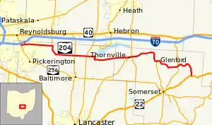
State Route 204 (SR 204) is a state route in central Ohio. It starts at SR 256 in Pickerington, and ends at US 22 near Mount Perry. At a length of 37.79 miles (60.82 km), the route is located parallel to Interstate 70 in Fairfield and Perry counties east of Columbus, the state capital.
State Route 204 | ||||
|---|---|---|---|---|
 | ||||
| Route information | ||||
| Maintained by ODOT | ||||
| Length | 37.79 mi[1][2] (60.82 km) | |||
| Existed | 1924–present | |||
| Major junctions | ||||
| West end | ||||
| East end | ||||
| Location | ||||
| Country | United States | |||
| State | Ohio | |||
| Counties | Fairfield, Perry | |||
| Highway system | ||||
| ||||
| ||||

History
SR 204 was designated in 1923 on what was formerly SR 470 (which existed since 1915[3]) between SR 79 (current SR 37) and SR 40, US 22's predecessor.[4][5] In 1937, SR 204 was extended west along local roads and SR 386 to SR 256.[6][7] Since then, no major, functional changes have occurred to the routing.[8]
Major intersections
| County | Location | mi[1][2] | km | Destinations | Notes |
|---|---|---|---|---|---|
| Fairfield | Pickerington | 0.00 | 0.00 | ||
| Violet Township | 0.81 | 1.30 | SR 204A | ||
| Liberty Township | 5.81 | 9.35 | Southern terminus of SR 310 | ||
| 11.16 | 17.96 | ||||
| Walnut Township | 13.31 | 21.42 | |||
| Perry | Thornville | 21.56 | 34.70 | Eastern terminus of SR 188 | |
| Thorn Township | 22.28 | 35.86 | |||
| Hopewell Township | 28.55 | 45.95 | Northern terminus of SR 757 | ||
| 33.01 | 53.12 | ||||
| Madison Township | 37.79 | 60.82 | |||
| 1.000 mi = 1.609 km; 1.000 km = 0.621 mi | |||||
State Route 204A

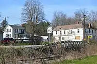
State Route 204A is a 0.49-mile[1] alternate route connecting I-70 with SR 204 in Pickerington. Route 204A runs south from I-70 to SR 204, connecting the two parallel roads. Route 204A also serves as the off ramp for I-70 until it becomes Taylor Road and intersects SR 204. A No Outlet sign is posted because the I-70 off ramp is southbound only and there is no access northbound to I-70.
References
- Ohio Department of Transportation. "Technical Services DESTAPE - Fairfield County" (PDF). Retrieved 2013-11-27.
- Ohio Department of Transportation. "Technical Services DESTAPE - Perry County" (PDF). Retrieved 2013-11-27.
- Map of Ohio Showing Main Market Roads and Inter-County Highways (MrSID) (Map). Cartography by Clinton Cowen, State Highway Commissioner. Ohio State Highway Department. 1915. Retrieved August 18, 2013.
- Map of Ohio State Highways Showing All Improved Roadways (MrSID) (Map). Cartography by E.C. Blosser. Ohio Department of Highways and Public Works. 1922. Retrieved August 18, 2013.
- Map of Ohio Showing State Routes (MrSID) (Map). Cartography by L.A. Boulay, Director. ODOH. 1923. Retrieved August 18, 2013.
- 1936 Official Highway Map (MrSID) (Map). Cartography by John Jaster, Jr., Director. ODOH. 1936. Retrieved August 19, 2013.
- Official Ohio Highway Map 1937 (MrSID) (Map). Cartography by John Jaster, Jr., Director. ODOH. 1937. Retrieved August 19, 2013.
- 2007-2009 Official Ohio Transportation Map (MrSID) (Map). Cartography by James G. Beasley, Director. ODOT. 2007. Retrieved August 20, 2013.
