Nuwara Eliya District
Nuwara Eliya District (Tamil: நுவரெலியா மாவட்டம், romanized: Nuvareliyā Māvaṭṭam; Sinhala: නුවරඑළිය දිස්ත්රික්කය, romanized: Nuvaraeḷiya Distrikkaya) is a district in Central Province, Sri Lanka, centered on the tourist city of Nuwara Eliya.
Nuwara Eliya District
நுவரெலியா மாவட்டம் නුවරඑළිය දිස්ත්රික්කය | |
|---|---|
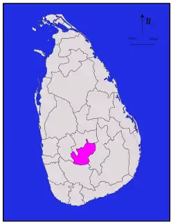 Map of Sri Lanka with Nuwara Eliya District highlighted | |
| Coordinates: 7°00′N 80°45′E | |
| Country | Sri Lanka |
| Province | Central Province |
| Largest Town | Nuwara Eliya |
| Divisions | List
|
| Government | |
| • District Secretary | M. B. R. Pushpakumara |
| • Local | List
|
| Area | |
| • Total | 1,741 km2 (672 sq mi) |
| • Land | 1,706 km2 (659 sq mi) |
| • Water | 35 km2 (14 sq mi) |
| Population (2013) | |
| • Total | 731,415 |
| • Density | 420/km2 (1,100/sq mi) |
| Time zone | UTC+05:30 (Sri Lanka) |
| ISO 3166 code | LK-23 |
| Website | |
Demographics
| Ethnic groups | |||
|---|---|---|---|
| Indian Tamil | 355,830 | (50.57%) | |
| Sinhalese | 282,621 | (40.17%) | |
| Sri Lankan Tamil | 46,066 | (6.55%) | |
| Sri Lankan Moor | 16,555 | (2.35%) | |
| Burgher | 632 | (0.09%) | |
| Sri Lankan Malay | 1,059 | (0.15%) | |
| Other | 847 | (0.12%) | |
| Religions | |||
|---|---|---|---|
| Hinduism | 359,135 | (51.04%) | |
| Buddhism | 279,139 | (39.67%) | |
| Islam | 19,099 | (2.71%) | |
| Roman Catholic | 35,008 | (4.98%) | |
| Other Christian | 10,741 | (1.53%) | |
| Other | 488 | (0.07%) | |
Religion in Nuwara Eliya District (2011)[1]
The population according to 2001 census is 703,610 of which 50.61% Tamils of Indian origin, 40.2% are Sinhalese, 6.5% native Sri Lankan Tamils and 2.4% Sri Lankan Moors. In terms of religion,51.0% of the population are Hindu, 39.7.0 % Buddhists, 5% Roman Catholics, 2.7% Muslims and 1.5% belong to non-catholic Christian denominations.[2]
Geography

Nuwara Eliya district is located in the hill country of Central Province. The terrain is generally mountainous, with deep valleys.
Cities
- Nuwara Eliya (Municipal Council)
Towns
- Agrapatana
- Ambewela
- Bogawantalawa
- Bopattalawa
- Dayagama Bazaar
- Ginigathena
- Hapugastalawa
- Haggala
- Hanguranketha
- Hatton-Dikoya UC
- Kotagala
- Kotmale
- Labukele
- Laxapana
- Lindula-Talawakele UC
- Maskeliya
- Nildandahinna
- Nuwara Eliya
- Nanu Oya
- Norton Bridge
- Padiyapelella
- Ramboda
- Ragala
- Rikillagaskada
- Rozella
- Udapussallawa
- Walapane
- Watawala
- Norton
- Koththallena
- Pundaluoya
- Kandapola
- Pattipola
Schools
Poramadulla Central College is located in the Rikillagaskada community in Hanguranketha.[3]
Diyathilaka Central College is located in the Hanguranketha community in Hanguranketha.
References
- Department of Census and Statistics,The Census of Population and Housing of Sri Lanka-2011
- Department of Census and Statistics official government website
- S.M. Jiffrey Abdeen (March 10, 2012), Poramadulla CC makes progress despite difficulties, Daily News (Sri Lanka), archived from the original on December 8, 2013, retrieved December 7, 2013
{{citation}}: CS1 maint: bot: original URL status unknown (link) ()