North Country (New York)
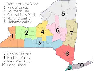
The North Country (French: Pays du Nord) is the northernmost region of the U.S. state of New York, bordered by Lake Champlain to the east, the Adirondack Mountains and the Upper Capital District to the south, the Mohawk Valley region to the southwest, the Canadian border to the north, and Lake Ontario and the Saint Lawrence Seaway to the west.[1] A mostly rural area, the North Country includes seven counties. Fort Drum, a U.S. Army base, is also located in the North Country, as is the Adirondack Park. As of 2009, the population of the region was 429,092.[2]

| Part of a series on |
| Regions of New York |
|---|
 |
The term "North Country" was first widely popularized within New York by the 1900 novel Eben Holden by Irving Bacheller.[3]
Counties

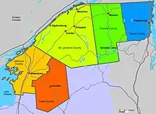
According to the Empire State Development Corporation, the North Country encompasses the following seven counties:[2]
- Clinton County
- Essex County
- Franklin County
- Hamilton County
- Jefferson County
- Lewis County
- St. Lawrence County
However, according to the Adirondack North Country Association, the North Country consists of 14 counties; those listed above and the following:
- Fulton County
- Herkimer County
- Oneida County
- Oswego County
- Saratoga County
- Warren County
- Washington County
These are all counties in which part of Adirondack State Park resides.[4]
Herb Hallas summarizes both views:[5]
The state-sanctioned North Country extends from the eastern shore of Lake Ontario to the western edge of Lake Champlain, and from the Canadian border on the north to the southern boundary of Hamilton County. As such, it is much larger and more stable than either of the traditionalist North Countries. The state-sanctioned North Country consists of Clinton, Essex, Franklin, Hamilton, St. Lawrence, Jefferson and Lewis Counties. The New York State Department of Labor, the New York State Regional Development Council, and the Empire State Development Agency serve people who live in the state-sanctioned North Country. The contemporary North Country takes in the largest area of all the North Countries. It extends from the Canadian border on the north to the Erie Canal on the south, and from the shores of Lake Ontario in the west to the edge of Lake Champlain in the east. The contemporary North Country includes all of the Adirondack Park, 14 counties, 14 cities, 255 towns and almost 40 percent of the state’s geographic area. The Adirondack North Country Association, an economic development organization that also promotes tourism, serves people living in the contemporary North Country, as does North Country Public Radio.
References
- "North Country Alliance::: Vision". citec.org.
- "Welcome to Empire State Development". esd.ny.gov. 24 October 2016.
- Hallas, Herb (30 May 2013). "Where Exactly is the North Country?". Adirondack Almanack.
- Adirondack North Country Association. "Where We Work?". Adirondack North Country Association.
- Hallas, Herb (30 May 2013). "Where Exactly is the North Country?". Adirondack Almanack.