Nelgesin Range
The Nelgesin Range (Russian: Нельгесинский хребет)[1][2] is a mountain range in the Sakha Republic (Yakutia), Far Eastern Federal District, Russia. The nearest city is Batagay to the north of the range.[3]
| Nelgesin Range | |
|---|---|
| Нельгесинский хребет / Нэльгэһэ | |
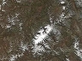 Nelgesin Range Sentinel-2 image | |
| Highest point | |
| Peak | Unnamed |
| Elevation | 1,926 m (6,319 ft) |
| Coordinates | 65°59′21″N 135°51′58″E |
| Dimensions | |
| Length | 140 km (87 mi) NE/SW |
| Width | 40 km (25 mi) NW/SE |
| Geography | |
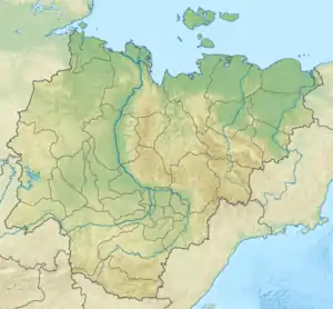 Location in Sakha, Russia | |
| Country | Russia |
| Federal subject | Sakha Republic |
| Range coordinates | 66°03′N 136°04′E |
| Parent range | Yana-Oymyakon Highlands Chersky Range, East Siberian System |
| Climbing | |
| Easiest route | From Batagay |
The nearest airport is Batagay Airport.[4]
Geography
The Nelgesin Range rises in the area of the Yana-Oymyakon Highlands, part of the Chersky Mountains, to the west of the Adycha and north of the Derbeke.[4] It stretches in a roughly southwest–northeast direction for about 140 kilometers (87 mi),[5] with the Adycha at its northern end. The highest peak is a 1,926 metres (6,319 ft) high unnamed summit.[6]
The smaller Tirekhtyakh Range, another subrange of the Chersky Mountains, rises to the north, stretching parallel to the general direction of the Nelgesin Range.[7]
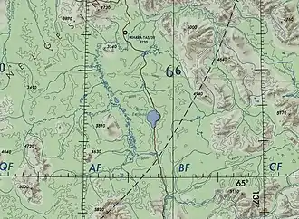 The southern end of the Nelgesin Range to the north of lake Emanda. |
References
- Аркадий Андреев, Горы Якутии (Arkady Andreyev, Mountains of Yakutia) p. 22
- Общая характеристика территории
- Moss flora of the Ust-Nera region in the upper course of Indigirka River, East Yakutia
- Google Earth
- Changes to the physical map of Northeast Asia
- USSR 1:1,000,000 scale Operational Navigation Chart, Sheet C-6, 3rd edition
- Geographical Atlas of Russia. - Federal Agency for Geodesy and Cartography , AST, 2010. - pp. 118-119