Nöbdenitz
Nöbdenitz is a village and a former municipality in the district Altenburger Land, in Thuringia, Germany. Since 1 January 2019, it is part of the town Schmölln.
.jpg.webp)
Nöbdenitz | |
|---|---|
 | |
Location of Nöbdenitz | |
 Nöbdenitz 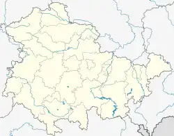 Nöbdenitz | |
| Coordinates: 50°52′38″N 12°17′6″E | |
| Country | Germany |
| State | Thuringia |
| District | Altenburger Land |
| Town | Schmölln |
| Area | |
| • Total | 10.01 km2 (3.86 sq mi) |
| Elevation | 229 m (751 ft) |
| Population (2017-12-31) | |
| • Total | 857 |
| • Density | 86/km2 (220/sq mi) |
| Time zone | UTC+01:00 (CET) |
| • Summer (DST) | UTC+02:00 (CEST) |
| Postal codes | 04626 |
| Dialling codes | 034496 |
| Vehicle registration | ABG |
| Website | www.noebdenitz.de |
Geography
Neighboring municipalities
Municipalities near Nöbdenitz are Drogen, Löbichau, Posterstein, the city of Schmölln, Vollmershain, and Wildenbörten.
Municipal arrangement
The municipality of Nöbdenitz consists of 5 subdivisions: Nöbdenitz, Burkersdorf (in Schmölln), Lohma, Untschen, and Zagkwitz.
Business and transportation
Nöbdenitz has a train station on the line that goes from Gera to Gößnitz as well as to Altenburg.
History
Within the German Empire (1871–1918), Nöbdenitz was part of the Duchy of Saxe-Altenburg.
References
- Huggler, Justin (5 Jun 2014). 'Oldest' oak tree in Europe faces the axe.
{{cite book}}:|work=ignored (help)
This article is issued from Wikipedia. The text is licensed under Creative Commons - Attribution - Sharealike. Additional terms may apply for the media files.