Mynydd Ceiswyn
Mynydd Ceiswyn is a mountain in Wales. It is the peak south of Waun-oer in the Dyfi Hills. On the east side of the mountain is the valley of the Nant Ceiswyn, and Cwm Hengae lies to the south.
| Mynydd Ceiswyn | |
|---|---|
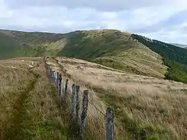 The ridge of Mynydd Ceiswyn, looking towards Waen-oer | |
| Highest point | |
| Elevation | 605 m (1,985 ft)[1] |
| Prominence | 27 m (89 ft) |
| Coordinates | 52.70890045°N 3.81845291°W |
| Naming | |
| Language of name | Welsh |
| Geography | |
| Location | Snowdonia, Wales |
| Parent range | Cadair Idris |
| OS grid | SH 7724 1390 |
| Topo map | OS Explorer OL23 |
Two minor dip faults cross the mountain,[2] and the Ceiswyn Formation is named after this mountain.[3]
References
- "MYNYDD CEISWYN, GWYNEDD (SY20 9RZ)". Ordnance Survey. Retrieved 9 September 2019.
- Geological Society of London (1928). The Quarterly Journal.
- Proceedings / Geologists' Association. 1945.
This article is issued from Wikipedia. The text is licensed under Creative Commons - Attribution - Sharealike. Additional terms may apply for the media files.