Mynydd Epynt
Mynydd Epynt (Welsh: [ˈmənɨð ˈɛpɨnt]) is a former community and upland area in Powys, Wales.
| Mynydd Epynt | |
|---|---|
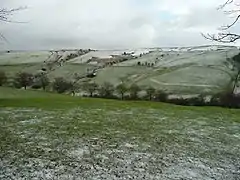
 View east from Blaen Bwch Farm | |
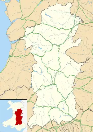
 Mynydd Epynt Location within Powys | |
| OS grid reference | SN 961464 |
| Principal area | |
| Preserved county | |
| Country | Wales |
| Sovereign state | United Kingdom |
| Police | Dyfed-Powys |
| Fire | Mid and West Wales |
| Ambulance | Welsh |
The Ministry of Defence controversially evicted the community of Mynydd Epynt in 1940, creating what is now the core of the Sennybridge Training Area (SENTA), the largest military training zone in Wales.
Etymology
The name of the area is often given as Mynydd Eppynt or Eppynt in historical sources and it appears under this spelling in the 1911 Encyclopædia Britannica.[1]
Mynydd is the Welsh word for "mountain" or "upland area" but the meaning of Epynt is less certain. The most commonly stated etymology is "a pathway for horses", deriving from the P-Celtic root epos, meaning "horse" (as in ebol, meaning "a foal" in Modern Welsh). However, Thomas Morgan suggested the name may be interpreted as a place where "the way (referring to the ancient mountain trackway) rises abruptly", deriving from eb- ("an issuing out") and -hynt (a "way" or "course").[2] A ridge continuing south-west from Mynydd Epynt is known as Mynydd Bwlch-y-groes, which may be translated as "mountain at the cross-road pass" or else "mountain at the pass of the cross".[3][4]
These etymologies all suggest that the area was known since ancient times as a place where important upland routes intersected, routes still largely extant in the modern era as drovers' roads.
History
Prehistory
_(cropped).jpg.webp)
The area attracted antiquarian interest from as early as 1809, when Theophilus Jones described a number of enclosures, cairns and stone circles. Modern archaeologists have surveyed the sites at Ynys Hir, Cornelau Uchaf and Twyn y Post, including what has since been described as a "prehistoric monument complex".[5]
Many of the features on Mynydd Epynt are known to be Bronze Age in origin, but the diversity of these monuments suggest they did not share a common purpose and that there were numerous phases of construction, in different historical eras. Some of the older monuments form part of later construction areas. These older sites were either reincorporated or left undisturbed, demonstrating a continued understanding of their importance and a respect for the beliefs of previous generations and cultures.[6] The monuments are located near the trackways that cross Mynydd Epynt, and many are positioned at crossroads.[5]
Later history
The modern community of Mynydd Epynt was active from at least the Medieval period, with archaeological surveys detailing preserved field systems, undisturbed by modern farming methods.[7][8]
The importance of the area's trackways is evidenced by the four droving inns that were established on the northern side of Mynydd Epynt (The Griffin Inn, Tafarn y Mynydd, Spite Inn and The Drover's Arms). Following the Ministry of Defence's acquisition in 1940, the Drover's Arms became an important landmark within the Sennybridge Training Area (SENTA). The inn's exterior was restored in the 1990s despite its continued use in active military training.[9]
The inns were part of an active Welsh-speaking community, with a school, church, and numerous chapels holding regular cultural events such as Eisteddfodau and Gymanfa Ganu. A noted custom of the community was to lay out a white sheet whenever a family was in need of help; this would act as a signal to the rest of the community, who would make their way to the house and offer their assistance.[10]
Military acquisition
Expansion and developments

Training operations have destroyed most of the original structures that formed the community of Mynydd Epynt, including chapels and their cemeteries. However, an artificial village was constructed in 1988. The Fighting In Built Up Areas zone (FIBUA) saw the construction of many mock buildings, including a fake chapel with imitation gravestones.[11]
Since the 1990s, the army have expanded the SENTA area and most of Mynydd Epynt is now subject to restricted access because of the use of live ammunition and explosives. Although explosives have destroyed the agricultural land, sheep grazing continues within the area under communal grazing and letting licences.[10]
One of the homes acquired in 1940, Disgwylfa, was refurbished in the 1990s as a conservation centre. The property was again refurbished and re-opened in 2009 as Canolfan Epynt (the Epynt Centre).[12]
Despite the closure of the ancient trackways over Mynydd Epynt, SENTA's outlying areas continued to be Open Country or open access land. In 2004, The MOD created a long-distance path around the perimeter of the range. The Epynt Way is a circular route designed for walkers, horse riders and mountain-bikers.[13]
The area was chosen as a special stage in the Wales Rally GB from 2006 to 2008.
Geography

The area of Mynydd Epynt is bounded to the south by the upper stretch of the Usk Valley and the Brecon Beacons National Park, to the north by the Irfon valley, and to the east by the valley of the River Wye. Its western boundary is less distinct but lies east of the A483 Llandovery to Llanwrtyd Wells road.
The area is an extensive plateau lying between 400 and 450m, drained by several southward-flowing rivers that empty into the River Usk; these include (from west to east) the Cilieni, Nant Bran, Afon Ysgir (with its two headwaters the Ysgir Fechan and Ysgir Fawr) and Afon Honddu. The Duhonw drains north-eastward into the River Wye.[14] The highest point is a Marilyn (having topographic prominence of at least 150m) of 478m.
Geology
Mynydd Epynt is largely formed from the Raglan Mudstone Formation and the St Maughans Formation of the Old Red Sandstone laid down during the latest part of the Silurian period and the succeeding Devonian period though there is little in the way of rock exposures at the surface. The northern and western escarpment of Mynydd Epynt is formed from a suite of rocks assigned to the Ludlow stage of the late Silurian and which include the Temeside Mudstone, the Tilestones, the Cae'r Mynach, Fibua, Aberedw, Cwm Craig Ddu and Irfon Formations. These consist variously of sandstones, mudstones and siltstones.
There is a broken spread of glacial till across the area resulting from its inundation by ice from the mid-Wales ice sheet to the north during the ice ages and hill peat has accumulated in some areas in post-glacial times.[15]
Welsh TT motorcycle races

From 1948 to 1953 the area was used for yearly motorcycle road racing.[16] Announced at the Motorcycle Live show in late 2017, a new organisation, Welsh Road Race, proposed to once again organise road racing, based on a repeal of certain clauses within the UK Road Traffic Act regulations that previously banned racing on public roads in the UK.[17] The Secretary of State for Defence granted the organisers a licence to re-use a 5.25-mile (8.45 km) circuit based on a network of private tarmacced roads contained within the Crown Estate, as was previously used to stage the historic Eppynt Motor Cycle Road Races.[16][18][19][20]
The anticipated return of road racing to this area in August 2018 was cancelled in early February 2018 because of unforeseen difficulties with the Welsh Road Traffic regulations, its time-frame considered too short for the ACU-sanctioned event, and it was postponed until 2019.[21] Unlike the Isle of Man TT races, which are free to attend, the organisers had already started to sell admission tickets via their website for the multi-category event over a long weekend.
The organisers include racer Jenny Tinmouth and former racer and TT rider Steve Plater, who also acts as a consultant development rider to Norton Motorcycles for their new V4 RR machine.[17][19][22]
In popular culture
Musician Gruff Rhys has a song called "Epynt" after the mountain, which features on his first solo album Yr Atal Genhedlaeth. The song is also about money, the E standing for the Euro, and pynt sounding similar to the Welsh word for "pound".
See also
- Capel Celyn, A Welsh community evacuated for the construction of a reservoir to supply water to Liverpool and Wirral.
- Imber
- Langford, Norfolk
- Mynydd Mallaen
- Tottington, Norfolk
- Tyneham
References
- Chisholm, Hugh, ed. (1911). . Encyclopædia Britannica. Vol. 04 (11th ed.). Cambridge University Press. p. 484: first para - In the north....
- Williams, Morgan (1912). "Breconshire". The Place-Names of Wales. Dalcassian Publishing Company. p. 36. Retrieved 14 August 2021.
- Owen, H. W.; Morgan, R. (2007). Dictionary of the Place-names of Wales. Ceredigion: Gomer Press.
- Morgan, R.; Powell, R. F. P. (1999). A Study of Breconshire Place-names. Llanrwst, Conwy: Gwasg Carreg Gwalch.
- Hall, J.J. (2009). "Cairns, Twyn-y-post, Upper Chapel". Coflein. Retrieved 15 August 2021.
- Silvester, R.J. (1992–1993). Parry, E.G. (ed.). "The Clwyd-Powys Archaeological Trust in Brecknockshire". Brycheiniog. 26: 11. Retrieved 14 August 2021.
- "Access Opportunities on the Defence Estate, Sennybridge Powys" (PDF). UK Government. Defence Estates. p. 1. Retrieved 16 August 2021.
- Hall, Sambrook, Jenny, Paul (June 2008). "Uplands Initiative Sennybridge Dry Training Area Archaeological Survey" (PDF). Trysor for: The Royal Commission on the Ancient and Historical Monuments of Wales Royal. Retrieved 16 August 2021.
{{cite web}}: CS1 maint: multiple names: authors list (link) - Driver, T. (31 May 2007). "Drovers's Arms, Duhonw". Coflein. Retrieved 16 August 2021.
- Tomos, Angharad (2 June 2020). "'It's the end of the world': Why we should remember the clearing of Epynt 80 years on". Nation.Cymru. Retrieved 17 August 2021.
- T, Driver (8 March 2005). "Sennybridge German Villa Ge; 'fibua' Training Facility". Coflein. Retrieved 18 August 2021.
- Hall, J.J. (2 May 2008). "Disgwylfa, Farmstead; Sennybridge Conservation Centre, Epynt Way Centre". Coflein. Retrieved 19 August 2021.
- "Epynt Way Website". Archived from the original on 17 February 2009. Retrieved 7 January 2009.
- Ordnance Survey Explorer maps 187 & 188 'Llandovery' & 'Builth Wells'
- British Geological Survey 1:50,000 map sheet 196 'Builth Wells' & accompanying sheet explanation
- Welsh Road Race History Retrieved 26 February 2018
- Who we are Welsh Road Race Retrieved 26 February 2018
- On the day Welsh Road Race Retrieved 26 February 2018
- Welsh Road Racing to return Classic Bike Guide, 7 February 2018. Retrieved 26 February 2018
- Roads: Welsh Road Race is go for 2018! Motorcycle News, 18 November 2017. Retrieved 26 February 2018
- Important News. The directors of the Welsh Road Race regretfully announce the postponement of the 2018 Welsh Road Race Welsh Road Race.com Retrieved 26 February 2018
- Norton development rider - Steve Plater Norton Motorcycles, Retrieved 26 February 2018