Myarth
Myarth is a hill in the Usk Valley in the county of Powys in South Wales, about 2 miles west of Crickhowell. Its summit at 292 metres (958 ft) is covered by trees, whilst the larger part of its slopes are also wooded. It is listed as a Marilyn. Myarth has an elongate form commonly ascribed to erosion by the west-to-east movement of the Usk Valley glacier during successive ice ages. The River Usk runs along the foot of the hill on its southern side. Myarth forms a prominent feature in many views over the Usk Valley and often features in commercial photography of the area.
| Myarth | |
|---|---|
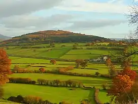 Myarth viewed from the west | |
| Highest point | |
| Elevation | 292 m (958 ft) |
| Prominence | 164 m (538 ft) |
| Parent peak | Allt yr Esgair |
| Listing | Marilyn in Wales |
| Naming | |
| Language of name | Welsh |
| Geography | |
| Location | Powys, Wales |
| OS grid | SO170208 |
Though it is ringed by public roads—the A40 to the north and a minor road to the south—there is no public access to the hill itself, which is in private ownership.[1]
In 2016, the hill was used as the location for a segment of an episode of the motoring series The Grand Tour.
References
- Ordnance Survey 1:25,000 scale Explorer map sheet OL 13 Brecon Beacons National Park: eastern area