Mount Göztepe
Mount Göztepe (Turkish: Göztepe Dağı or Kolibaba Dağı), is a mountain of 2594 meters high that naturally determines the border of Varto and Bulanık districts of Muş.[1]
| Mount Göztepe | |
|---|---|
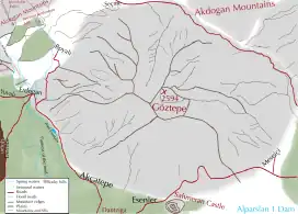 Map of the mountain | |
| Highest point | |
| Elevation | 2.594 m (8.51 ft) |
| Coordinates | 39°06′46″N 41°50′47″E |
| Geography | |
 Mount Göztepe Turkey | |
| Location | Varto, Bulanık, Muş Province, Turkey |
Geology and geomorphology
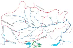
Geomap of region
Mount Göztepe is located in the south of Akdoğan mountains and in the north of Bilican mountains.[2] [3] It is one of the highest mountains of Muş province. There are more than 20 villages at the foot of the mountain.[4] Due to the similarity of the typical Armenian plateaus, it is very similar in terms of height, valley and shape to Mount Ara in Armenia.
References
- "Muş il fiziki haritası" (PDF) (in Turkish). Harita genel müdürlüğü. September 28, 2023. Archived (PDF) from the original on August 18, 2023.
- "Coğrafya". Bulanık ilçe milli eğitim müdürlüğü (in Turkish). Retrieved 2023-09-28.
- "Kaza of Bulanık - Geography". houshamadyan.org (in Turkish). Retrieved 2017-10-25.
- "Muş ilinde yaylaların dağılışı" (PDF) (in Turkish). Turkish Studies- International Balkan University. March 2019. p. 23. Archived (PDF) from the original on August 20, 2023.
Wikimedia Commons has media related to Mount Göztepe.
This article is issued from Wikipedia. The text is licensed under Creative Commons - Attribution - Sharealike. Additional terms may apply for the media files.