Mount Diablo meridian
The Mount Diablo meridian, established in 1851, is a principal meridian extending north and south from its initial point atop Mount Diablo in California at W 121° 54.845. Established under the U.S. Public Land Survey System, it is used to describe lands in most of northern California and all of Nevada.[1] Mount Diablo also marks the baseline at latitude 37°52′54″N.[2]

Mount Diablo Memorial Marker
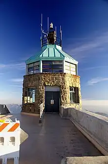
Summit beacon tower atop Mt. Diablo. The initial point marker lies within this tower.
References
-
- John W. Pettley, PLS. "Mount Diablo Survey Point Establishes Property Boundaries in California and Nevada". Mount Diablo Surveyors Historical Society. Retrieved 2012-09-27.
-
- "Mount Diablo Meridian". U.S. Bureau of Land Management. Archived from the original on 2017-01-06. Retrieved 2012-09-27.
External links
- "Mount Diablo Meridian, San Francisco, CA". Principal Meridian Project. Retrieved 2012-09-27.
- "Cadastral Survey: Principal Meridians and Base Lines". U.S. Bureau of Land Management. Archived from the original on 2012-10-18. Retrieved 2012-09-27.
This article is issued from Wikipedia. The text is licensed under Creative Commons - Attribution - Sharealike. Additional terms may apply for the media files.