Mississippi Mound Trail
The Mississippi Mound Trail is a driving tour of 33 sites adjoining U.S. Route 61 where indigenous peoples of the Mississippi Delta built earthworks.[1] The mounds were primarily built between 500 and 1500 AD,[2] but are representative of a variety of cultures known as the Mound Builders. Each site has a historical marker and is accessible by road.[3]

Official Logo
Opened in 2016,[1] the trail was a joint venture between the Mississippi Department of Archives and History, the Mississippi Department of Transportation and various other stakeholders.[4]
Mississippi Mound Trail sites
| Mound name | Mound location | Listed on NRHP | Photograph | Notes |
|---|---|---|---|---|
| Aden Mounds | Near Valley Park at 32°38′13.09″N 90°50′10.82″W | Yes | Type site for the Aden Phase (800–900 CE) of Lower Yazoo Basin Coles Creek culture chronology | |
| Anguilla Mound | Anguilla at 32°58′21″N 90°50′29″W | No | Site consists of a single mound | |
| Arcola Mounds | Near Arcola at 33°14′42″N 90°52′55″W | Yes | Only three of the original six mounds exist today. | |
| Batesville Mounds | Batesville at 34°20′51″N 89°55′25″W | Yes | 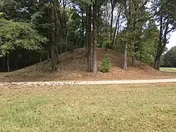 |
Originally consisted of seven mounds, with only four currently visible. Listed as a Mississippi Landmark. The Batesville Mounds listed on the National Register of Historic Places in 1989. [5] |
| Bayou Pierre Mounds | Near Port Gibson at 31°58′56″N 91°00′17″W | Yes | Consists of three mounds (and possibly a fourth) | |
| Beaverdam Mounds | Near Evansville at 34°37′44″N 90°23′39″W | Yes | Site consists of two earthen mounds and a former village | |
| Carson Mounds | Stovall at 34°17′37.4″N 90°40′16.04″W | Yes | 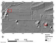 |
Only five of the original seven mounds currently exist |
| Carter Mounds | Near Rolling Fork at 32°55′22.6″N 90°53′00.3″W | No | Site consists of a platform mound and burial mound | |
| Cary Mounds | Cary at 32°48′14.5″N 90°55′53.0″W | Yes | Only one of four original mounds exists today | |
| Christmas Mound | Near Beulah at 33°46′10.6″N 90°58′43.6″W | No | Consists of a single mound with a private cemetery located atop the mound. | |
| Dunn Mounds | Near Lyon at 34°12′58.7″N 90°28′32.7″W | No | Site consists of three mounds | |
| Edgefield Mounds | Near Norfolk at 34°59′32.5″N 90°12′52.8″W | No | Consists of three mounds | |
| Emerald Mound | Stanton at 31°38′9.98″N 91°14′50.02″W | Yes | 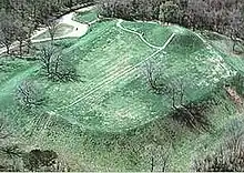 |
Type site for the Emerald Phase (1500 to 1680 CE) of the Natchez Bluffs Plaquemine culture chronology and second-largest Mississippian period earthwork in the country. Also a National Historic Landmark |
| Evansville Mounds | Evansville at 34°38′19.6″N 90°23′32.8″W | Yes | Originally consisted of four mounds but only two remain. An abandoned schoolhouse is located on Mound B. | |
| Foster Mounds | Near Washington at 31°36′03.4″N 90°19′40.9″W | Yes | 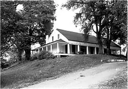 |
Consists of two mounds. An antebellum home is located on Mound A. |
| Grace Mounds | Grace at 32°59′23.4″N 90°58′12.6″W | Yes | Only two of the original five mounds currently exist | |
| Glass Mounds | Warrenton at 32°13′49.1″N 90°56′09.6″W | No | Possibly consisted of five mounds but only three are currently intact | |
| Grand Village of the Natchez | Natchez at 32°31′25.0″N 91°22′46.4″W | Yes | 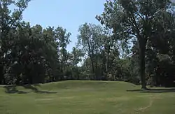 |
Originally contained six mounds, but only three are intact today. Occupied by the Natchez until 1730. Listed as a National Historic Landmark. |
| Haynes Bluff Mounds | Near Redwood at 32°31′26.9″N 90°46′47.0″W | No | Originally consisted of four mounds but only two remain today | |
| Hollywood Mounds | Near Hollywood at 34°46′39.2″N 90°22′13.7″W | No | 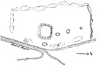 |
Originally consisted of one large mound and multiple boundary mounds, but only the platform mound and three boundary mounds remain today. Also a Mississippi Landmark. |
| Jaketown Mounds | Near Deovolente at 33°14′13.542″N 90°29′13.2936″W | Yes | 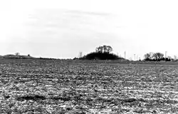 |
Once consisted of eighteen mounds but only three are visible today. Also a Mississippi Landmark and National Historic Landmark. |
| Johnson Cemetery Mound | Hollywood at 34°44′27.0″N 90°21′57.5″W | Yes | Site consists of a mound and accompanying village. A private cemetery is located on the mound. | |
| Law Mounds | Foote at 33°05′17.0″N 91°01′09.1″W | No | Only one of the original three mounds exists today. | |
| Lake George Mounds | Holly Bluff at 32°48′51.2″N 90°41′02.5″W | Yes | 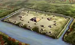 |
Consisted of up to twenty eight mounds but only a few are currently visible. Listed as a National Historic Landmark. |
| Lessley Mound | Near Woodville at 31°09′30.2″N 91°26′25.9″W | No | Site consists of a single mound with the Lessley family cemetery located atop the mound | |
| Mont Helena Mounds | Near Rolling Fork at 32°56′39.6″N 90°52′12.7″W | No | 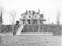 |
Possibly consisted of three mounds, but only one exists today. A Victorian neoclassical home currently sits atop the mound. |
| Pocahontas Mounds | Pocahontas, Mississippi at 32°28′9.37″N 90°17′17.81″W | Yes |  |
Site contains two mounds. Also listed as a Mississippi Landmark. |
| Rolling Fork Mounds | Rolling Fork at 32°53′47.7″N 90°52′44.0″W | Yes | 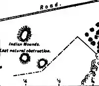 |
Originally consisted of three mounds but only two remain today |
| Salomon Mounds | Near Coahoma at 34°22′39.3″N 90°29′24.2″W | Yes | Possibly consisted of twelve mounds, but only three exist today. A private cemetery is located atop Mound A. | |
| Smith Creek Mounds | Near Fort Adams at 31°08′22.0″N 91°30′59.1″W | Yes | Site consists of three mounds | |
| Swan Lake Mounds | Near Foote at 33°05′58.0″N 90°59′54.5″W | No | Originally included four mounds but only two exist today | |
| Windsor Mounds | Bruinsburg at 31°56′45.2″N 91°07′36.4″W | Yes | Site consists of four mounds with a private cemetery located on Mound C. | |
| Winterville Mounds | Near Winterville at 33°29′9″N 91°3′40″W | Yes | 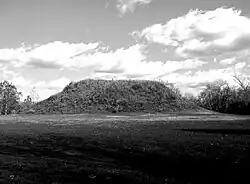 |
Originally consisted of more than twenty mounds. Listed as a Mississippi Landmark and National Historic Landmark. |
References
- "County Sites Play Big Role In Mississippi Mound Trail". Retrieved 2020-12-31.
- "New Indian Mound Trail is ancient history". Retrieved 2020-12-31.
- "Book Review: 'The Natchez Indians: A History to 1735'". Retrieved 2020-12-31.
- "Mississippi Mounds Trail". Retrieved 2020-12-31.
- Howell, John (14 June 2013). "Pan-Gens ask to have Batesville included on mound trail 6/14/13". The Panolian.
External links
This article is issued from Wikipedia. The text is licensed under Creative Commons - Attribution - Sharealike. Additional terms may apply for the media files.