Melderskin
Melderskin is a mountain peak in Kvinnherad kommune in Hordaland. The mountain, which has a height of 1,426 metres (4,678 ft) above sea level,[1] is located just behind Barony of Rosendal.[2] In the middle of the mountain there is a small U-valley where the waterfall begins, and the U-valley lies between two mountain peaks as seen in the image.
| Melderskin | |
|---|---|
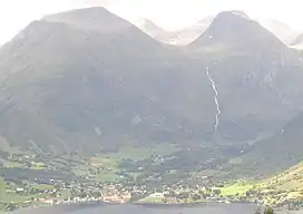 Rosendal under Melderskin (left) and Laurdalstind (1,307 meters above sea level). Seen from Veten on Snilstveitøy | |
| Highest point | |
| Elevation | 1,426 m (4,678 ft)[1] |
| Coordinates | 60°1′N 6°7′E |
| Geography | |
 Melderskin Location of the mountain in Vestland, Norway | |
| Location | Kvinnherad, Vestland, Norway |
| Parent range | Scandinavian Mountains |
Melderskin is the nearest mountain to Ben Nevis (the highest mountain in the United Kingdom) that is higher than Ben Nevis, and therefore defines the topographic isolation of Ben Nevis: 459 miles (739 kilometres).[3]
The name comes from the Norse words reports, which means 'grain that is ground into flour' and skin which means shine or shine. The meaning then becomes "the mountain with a shiny layer of snow on top".[4]
References
- Melderskin on Norgeskart.no from Statens kartverk
- Melderskin i Rosendal, lommekjent.no
- "Isolation for Ben Nevis - Peakbagger.com". www.peakbagger.com.
- Rosendal - Fjord og Fjell: Melderskin Archived 2016-02-15 at the Wayback Machine, rosendal.net
External links
- Map and tour description, visitsunnhordland.no