McFarland Peak
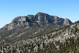
McFarland Peak is a limestone peak in the northern portion of the Spring Mountains in Clark County of southern Nevada. It is in the Toiyabe National Forest and the Mount Charleston Wilderness.
| McFarland Peak | |
|---|---|
 | |
| Highest point | |
| Elevation | 10,749 ft (3,276 m) NAVD 88[1] |
| Prominence | 1,165 ft (355 m)[1] |
| Coordinates | 36°20′29″N 115°43′32″W[2] |
| Geography | |
 McFarland Peak | |
| Parent range | Spring Mountains |
| Topo map | USGS Charleston Peak |
McFarland Peak is located north of Mount Charleston and southwest of Macks Peak.
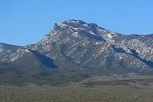
McFarland Peak seen from Indian Ridge
References
- "McFarland Peak, Nevada". Peakbagger.com. Retrieved 2010-10-01.
- "McFarland Peak". Geographic Names Information System. United States Geological Survey, United States Department of the Interior. Retrieved 2010-10-01.
This article is issued from Wikipedia. The text is licensed under Creative Commons - Attribution - Sharealike. Additional terms may apply for the media files.