Mayan Corridor mangroves
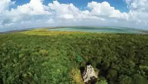
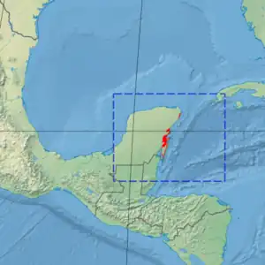
The Mayan Corridor mangroves ecoregion (WWF ID: NT1421) covers the mangrove habitats along the Caribbean Sea coast of the state of Quintana Roo in southern Mexico and a narrow strip on the north of Belize. The region is named for the Maya Civilization archeological sites along the coast. Biodiversity in the area high due to the interactions of different environments - coastal lagoons, river estuaries, coral reefs, and barrier beaches. The ecoregion supports Mexico's largest population of crocodiles (Crocodylus moreletii).[1][2][3]
| Mayan Corridor mangroves | |
|---|---|
 | |
 Ecoregion territory (in red) | |
| Ecology | |
| Realm | Neotropic |
| Biome | Mangroves |
| Geography | |
| Area | 4,144 km2 (1,600 sq mi) |
| Countries | |
| Coordinates | 19.9°N 87.5°W |
Location and description
Mangroves cover most of the east-facing coast of Yucatan, from Cancun in the north to the east side of Chetumal Bay in the south on the border with Belize. The mangroves generally extend only a few kilometers inland from the lagoons and river deltas they surround. The ecoregion immediately inland of the Mayan Corridor mangroves is the Yucatán moist forests ecoregion.[4]
In the north, there is a 50 km stretch of mangroves from Cancun to the town of Playa del Carmen, opposite the island of Cozumel. Further south are the coastal lagoons of Sian Ka'an Biosphere Reserve, around which are 23 archeological sites of the Maya civilization. This mangrove area extends along lagoons behind coastal dunes all the way south to the border with Belize.[2]
Climate
The climate of the ecoregion is Tropical savanna climate - dry winter (Köppen climate classification (Aw)). This climate is characterized by relatively even temperatures throughout the year, and a pronounced dry season. The driest month has less than 60 mm of precipitation, and is drier than the average month.[5][6] Average annual precipitation in the ecoregion is 1,600 mm/year.[1]
Flora and fauna
Mangrove trees in the ecoregion are characteristically red mangrove (Rhizophora mangle), white mangrove (Laguncularia racemosa), Black mangrove (Avicennia germinans), and button mangrove (Conocarpus erectus).[1] Also present are 'pygmy mangrove' that includes swamp sawgrass (Cladium mariscus) and spikerushes (Eleocharis cellulosa).
There have been 96 species of mammals recorded in the area, including the jaguar (Panthera onca), puma (Felis concolor), ocelot (Leopardus pardalis), and manatee (Trichechus manatus).[1]
References
- "Mayan Corridor mangroves". World Wildlife Federation. Retrieved November 20, 2020.
- "Map of Ecoregions 2017". Resolve, using WWF data. Retrieved November 20, 2020.
- "Mayan Corridor mangroves". The Encyclopedia of Earth. Retrieved November 20, 2020.
- "Sian Ka'an". RAMSAR Sites Information Service. Retrieved November 20, 2020.
- Kottek, M., J. Grieser, C. Beck, B. Rudolf, and F. Rubel, 2006. "World Map of Koppen-Geiger Climate Classification Updated" (PDF). Gebrüder Borntraeger 2006. Retrieved September 14, 2019.
{{cite web}}: CS1 maint: multiple names: authors list (link) - "Dataset - Koppen climate classifications". World Bank. Retrieved September 14, 2019.