Mammamattawa, Ontario
Mammamattawa is a dispersed rural community and unincorporated place in the Unorganized North Part of Cochrane District in northeastern Ontario, Canada.[1][3][4][5] It is located at the mouth of the Kabinakagami River at the Kenogami River, just 2 kilometres (1.2 mi) downstream of the mouth of the Nagagami River at the Kenogami, in the James Bay drainage basin.[3][6]
Mammamattawa | |
|---|---|
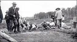
 Indians at English River Post, 1905 | |
 Mammamattawa Location of Mammamattawa in Ontario | |
| Coordinates: 50°24′40″N 84°21′59″W[1] | |
| Country | Canada |
| Province | Ontario |
| Region | Northeastern Ontario |
| District | Cochrane |
| Part | Cochrane, Unorganized, North |
| Elevation | 88 m (289 ft) |
| Time zone | UTC-5 (Eastern Time Zone) |
| • Summer (DST) | UTC-4 (Eastern Time Zone) |
| Postal code FSA | P0L |
| Area codes | 705, 249 |
The Constance Lake First Nation operates a camp at Mammamattawa.[7]
History
The first inland post of the Hudson's Bay Company, named Henley House, was established at the confluence of the Kenogami River and Albany River in 1743.[8][9] A new post was established in 1884 at the confluence of the Kenogami River and the Kabinakagami River.[10] It was known as the English River Post, as the Kenogami was also known as the English River.[11] The English River First Nation, the primary forerunner to today's Constance Lake First Nation, had a reserve set aside for their use just north of the post in 1912, which remains part of the Constance Lake First Nations lands as English River 66 Indian Reserve.[3][6][11][12] The Hudson's Bay Company English River Post was abandoned in 1941, and the place later took on its present First Nations name.
References
- "Mammamattawa". Geographical Names Data Base. Natural Resources Canada. Retrieved 2020-07-11.
- "Google Earth". Retrieved 2020-07-11.
- "Ontario Geonames GIS (on-line map and search)". Ontario Ministry of Natural Resources and Forestry. 2014. Retrieved 2020-07-11.
- "Toporama (on-line map and search)". Atlas of Canada. Natural Resources Canada. 12 September 2016. Retrieved 2020-07-11.
- Map 14 (PDF) (Map). 1 : 1,600,000. Official road map of Ontario. Ministry of Transportation of Ontario. 2018-01-01. Retrieved 2020-07-07.
- "English River Post" (PDF). Geology Ontario - Historic Claim Maps. Ontario Ministry of Energy, Northern Development and Mines. Retrieved 2020-07-11.
- "Mammamattawa Camp". Constance Lake First Nation. 2018. Retrieved 2020-07-11.
- Kudelik, Gail. "Albany River". The Canadian Encyclopedia. The Historica Dominion Institute. Retrieved 2011-08-19.
- "B.71 (Fly Lake) to B.88 (Hulse House) - Henley House". Hudson's Bay Company Archives. Archives of Manitoba. Retrieved 2011-08-19.
- "B. 371 (Beaver Lake Portage) to B.395 (Bucke) - English River Post". Hudson's Bay Company Archives. Archives of Manitoba. Retrieved 2011-08-19.
- "Our History". Constance Lake First Nation. 2018. Retrieved 2020-07-11.
- "English River 66". Geographical Names Data Base. Natural Resources Canada. Retrieved 2011-08-20.