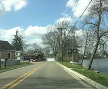
M-188 (Michigan highway)
M-188 is a 4.559-mile-long (7.337 km) state trunkline highway in the US state of Michigan. It runs from Eaton Rapids to the VFW National Home for Children, southeast of town through a rural area. Approximately 1,000 vehicles each day use a highway that was first designated in the 1930s and paved in the 1940s.
M-188 | ||||
|---|---|---|---|---|
M-188 highlighted in red | ||||
| Route information | ||||
| Maintained by MDOT | ||||
| Length | 4.559 mi[1] (7.337 km) | |||
| Existed | 1932–present | |||
| Major junctions | ||||
| West end | ||||
| East end | VFW National Home for Children southeast of Eaton Rapids | |||
| Location | ||||
| Country | United States | |||
| State | Michigan | |||
| Counties | Eaton, Ingham | |||
| Highway system | ||||
| ||||
Route description

Starting in Eaton Rapids, M-188 heads eastward from the intersection with M-99/M-50 (Michigan highway) toward the Grand River. The highway follows Water Street southeasterly along the river through residential neighborhoods and exits town. M-188 turns back due east on VFW Road to run through farm fields. Near the intersection with Tucker Road, the highway turns south and then southeasterly to avoid a bend in the river. After this bend, VFW Road once again runs due east to the intersection with Waverly Road. M-188 turns south on Waverly Road, which runs along the Eaton–Ingham county line. The M-188 designation ends at the VFW National Home for Children about one mile (1.6 km) south of VFW Road.[2][3]
M-188 is maintained by the Michigan Department of Transportation (MDOT) like other state highways in Michigan. As a part of these maintenance responsibilities, the department tracks the volume of traffic that uses the roadways under its jurisdiction. These volumes are expressed using a metric called annual average daily traffic, which is a statistical calculation of the average daily number of vehicles on a segment of roadway. MDOT's surveys in 2010 showed that 986 vehicles in the city of Eaton Rapids, and 1,103 used the trunkline outside of town, traveled along the highway on average.[4] M-188 has not been listed on the National Highway System,[5] a network of roads important to the country's economy, defense, and mobility.[6]
History
M-188 was designated in late 1932, providing highway access to the VFW National Home from Eaton Rapids in southeast Eaton County.[7][8] In early 1941, the trunkline was completely paved;[9][10] and the highway has been unchanged since.[2]
Major intersections
| County | Location | mi[1] | km | Destinations | Notes |
|---|---|---|---|---|---|
| Eaton | Eaton Rapids | 0.000 | 0.000 | ||
| Eaton– Ingham | Hamlin Township – Onondaga Township | 4.559 | 7.337 | VFW National Home for Children | |
| 1.000 mi = 1.609 km; 1.000 km = 0.621 mi | |||||
See also
References
- Michigan Department of Transportation (2021). Next Generation PR Finder (Map). Michigan Department of Transportation. Retrieved October 11, 2021.
- Michigan Department of Transportation (2011). Pure Michigan: State Transportation Map (Map). c. 1:975,000. Lansing: Michigan Department of Transportation. § L11. OCLC 42778335, 786008212.
- Google (January 9, 2012). "Overview Map of M-188" (Map). Google Maps. Google. Retrieved January 9, 2012.
- Bureau of Transportation Planning (2008). "Traffic Monitoring Information System". Michigan Department of Transportation. Retrieved April 8, 2011.
- Michigan Department of Transportation (April 23, 2006). National Highway System, Michigan (PDF) (Map). Scale not given. Lansing: Michigan Department of Transportation. Archived from the original (PDF) on October 4, 2012. Retrieved October 7, 2008.
- Natzke, Stefan; Neathery, Mike & Adderly, Kevin (June 20, 2012). "What is the National Highway System?". National Highway System. Federal Highway Administration. Retrieved July 1, 2012.
- Michigan State Highway Department & Rand McNally (October 1, 1932). Official Michigan Highway Map (Map). [c. 1:840,000]. Lansing: Michigan State Highway Department. § L11. OCLC 12701053.
- Michigan State Highway Department & Rand McNally (May 1, 1933). Official Michigan Highway Map (Map). [c. 1:840,000]. Lansing: Michigan State Highway Department. § L11. OCLC 12701053. Archived from the original on May 10, 2017. Retrieved December 18, 2016 – via Archives of Michigan.
- Michigan State Highway Department & Rand McNally (December 1, 1940). Official Michigan Highway Map (Map) (Winter ed.). [c. 1:850,000]. Lansing: Michigan State Highway Department. § L11. OCLC 12701143.
- Michigan State Highway Department & Rand McNally (March 21, 1941). Official Michigan Highway Map (Map) (Spring ed.). [c. 1:850,000]. Lansing: Michigan State Highway Department. § L11. OCLC 12701143.
External links
- M-188 at Michigan Highways
